Tin Can Ridge Topo Map Oregon
To zoom in, hover over the map of Tin Can Ridge
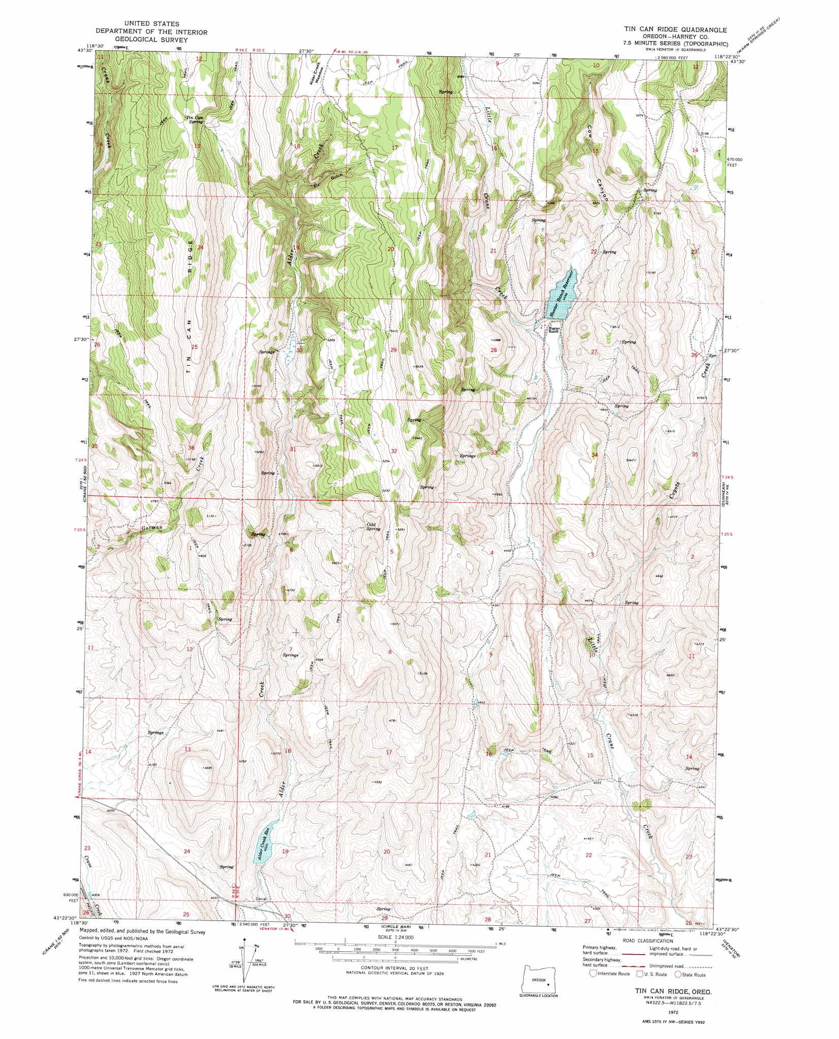
USGS Topo Quad 43118d4 - 1:24,000 scale
| Topo Map Name: | Tin Can Ridge |
| USGS Topo Quad ID: | 43118d4 |
| Print Size: | ca. 21 1/4" wide x 27" high |
| Southeast Coordinates: | 43.375° N latitude / 118.375° W longitude |
| Map Center Coordinates: | 43.4375° N latitude / 118.4375° W longitude |
| U.S. State: | OR |
| Filename: | o43118d4.jpg |
| Download Map JPG Image: | Tin Can Ridge topo map 1:24,000 scale |
| Map Type: | Topographic |
| Topo Series: | 7.5´ |
| Map Scale: | 1:24,000 |
| Source of Map Images: | United States Geological Survey (USGS) |
| Alternate Map Versions: |
Tin Can Ridge OR 1972, updated 1977 Download PDF Buy paper map Tin Can Ridge OR 2011 Download PDF Buy paper map Tin Can Ridge OR 2014 Download PDF Buy paper map |
1:24,000 Topo Quads surrounding Tin Can Ridge
Buchanan |
Stinkingwater Pass |
Bartlett Mountain |
Upton Mountain |
Selle Gap |
Carson Point |
Mahon Creek |
Coleman Mountain |
Warm Springs Creek |
Warm Springs Reservoir |
Warm Springs Butte |
Crane |
Tin Can Ridge |
Dunnean |
Mcewen Butte |
Malheur Lake East |
New Princeton |
Circle Bar |
Venator |
Venator Reservoir |
Barton Lake |
Adobe Flat |
Sand Gap |
South Fork Reservoir |
Duck Creek Butte |
> Back to 43118a1 at 1:100,000 scale
> Back to 43118a1 at 1:250,000 scale
> Back to U.S. Topo Maps home
Tin Can Ridge topo map: Gazetteer
Tin Can Ridge: Dams
Alder Creek Dam elevation 1234m 4048′Hunter Reservoir Dam elevation 1372m 4501′
Tin Can Ridge: Flats
Alder Creek Meadow elevation 1645m 5396′Tin Can Ridge: Reservoirs
Alder Creek Reservoir elevation 1226m 4022′Hunter Ranch Reservoir elevation 1372m 4501′
Tin Can Ridge: Ridges
Tin Can Ridge elevation 1721m 5646′Tin Can Ridge: Springs
Cold Spring elevation 1513m 4963′Tin Can Spring elevation 1641m 5383′
Tin Can Ridge: Streams
Coyote Creek elevation 1260m 4133′Tin Can Ridge: Valleys
Cow Canyon elevation 1387m 4550′Fir Gulch elevation 1549m 5082′
Tin Can Ridge digital topo map on disk
Buy this Tin Can Ridge topo map showing relief, roads, GPS coordinates and other geographical features, as a high-resolution digital map file on DVD: