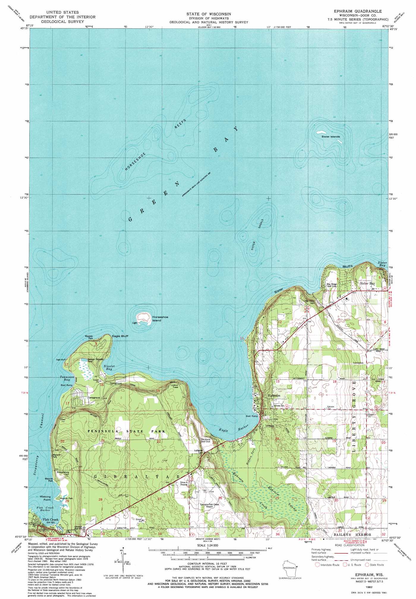
Ephraim Topo Map Wisconsin
To zoom in, hover over the map of Ephraim
USGS Topo Quad 45087b2 - 1:24,000 scale
| Topo Map Name: | Ephraim |
| USGS Topo Quad ID: | 45087b2 |
| Print Size: | ca. 21 1/4" wide x 27" high |
| Southeast Coordinates: | 45.125° N latitude / 87.125° W longitude |
| Map Center Coordinates: | 45.1875° N latitude / 87.1875° W longitude |
| U.S. State: | WI |
| Filename: | o45087b2.jpg |
| Download Map JPG Image: | Ephraim topo map 1:24,000 scale |
| Map Type: | Topographic |
| Topo Series: | 7.5´ |
| Map Scale: | 1:24,000 |
| Source of Map Images: | United States Geological Survey (USGS) |
| Alternate Map Versions: |
Ephraim WI 1982, updated 1983 Download PDF Buy paper map Ephraim WI 2010 Download PDF Buy paper map Ephraim WI 2013 Download PDF Buy paper map Ephraim WI 2016 Download PDF Buy paper map |
1:24,000 Topo Quads surrounding Ephraim
North Lake |
Cedar River |
Washington Island Nw |
||
Arthur Bay |
Ellison Bay |
Washington Island Sw |
||
Chambers Island Nw |
Chambers Island |
Ephraim |
Sister Bay |
Spider Island |
Green Island |
Egg Harbor |
Baileys Harbor West |
Baileys Harbor East |
|
Idlewild |
Institute |
Jacksonport |
> Back to 45087a1 at 1:100,000 scale
> Back to 45086a1 at 1:250,000 scale
> Back to U.S. Topo Maps home
Ephraim topo map: Gazetteer
Ephraim: Airports
Ephraim-Fish Creek Airport elevation 237m 777′Ephraim: Bars
Horseshoe Reefs elevation 177m 580′Sister Shoals elevation 177m 580′
Ephraim: Bays
Eagle Harbor elevation 177m 580′Fish Creek Harbor elevation 177m 580′
Nicolet Bay elevation 177m 580′
Tennison Bay elevation 177m 580′
Ephraim: Capes
Weborg Point elevation 177m 580′Ephraim: Cliffs
Eagle Bluff elevation 182m 597′Sister Bluffs elevation 177m 580′
Svens Bluff elevation 193m 633′
Ephraim: Islands
Horseshoe Island elevation 185m 606′Sister Islands elevation 177m 580′
Ephraim: Parks
Peninsula Park Beech Forest State Natural Area elevation 235m 770′Peninsula Park White Cedar Forest State Natural Area elevation 180m 590′
Peninsula State Park elevation 211m 692′
Sister Islands State Natural Area elevation 177m 580′
Ephraim: Populated Places
Ephraim elevation 201m 659′Fish Creek elevation 183m 600′
Ephraim: Streams
Ephraim Creek elevation 177m 580′Fish Creek elevation 177m 580′
Hidden Springs Creek elevation 177m 580′
Ephraim: Swamps
Ephraim Swamp elevation 181m 593′Ephraim digital topo map on disk
Buy this Ephraim topo map showing relief, roads, GPS coordinates and other geographical features, as a high-resolution digital map file on DVD: