Battleship Rock Topo Map South Dakota
To zoom in, hover over the map of Battleship Rock
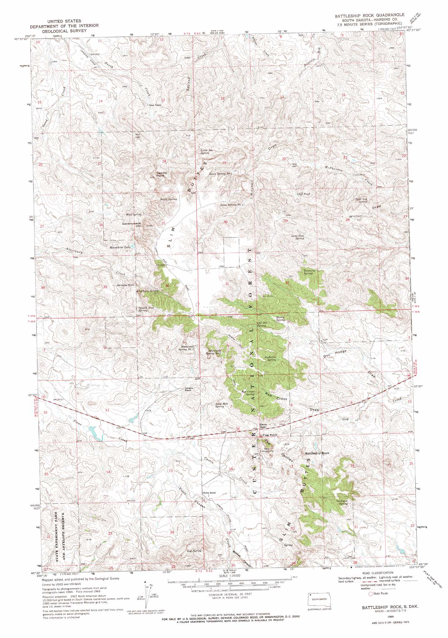
USGS Topo Quad 45103e2 - 1:24,000 scale
| Topo Map Name: | Battleship Rock |
| USGS Topo Quad ID: | 45103e2 |
| Print Size: | ca. 21 1/4" wide x 27" high |
| Southeast Coordinates: | 45.5° N latitude / 103.125° W longitude |
| Map Center Coordinates: | 45.5625° N latitude / 103.1875° W longitude |
| U.S. State: | SD |
| Filename: | o45103e2.jpg |
| Download Map JPG Image: | Battleship Rock topo map 1:24,000 scale |
| Map Type: | Topographic |
| Topo Series: | 7.5´ |
| Map Scale: | 1:24,000 |
| Source of Map Images: | United States Geological Survey (USGS) |
| Alternate Map Versions: |
Battleship Rock SD 1969, updated 1971 Download PDF Buy paper map Battleship Rock SD 1993, updated 1996 Download PDF Buy paper map Battleship Rock SD 2005, updated 2007 Download PDF Buy paper map Battleship Rock SD 2012 Download PDF Buy paper map Battleship Rock SD 2015 Download PDF Buy paper map |
| FStopo: | US Forest Service topo Battleship Rock is available: Download FStopo PDF Download FStopo TIF |
1:24,000 Topo Quads surrounding Battleship Rock
Ludlow |
Ludlow Se |
Ralph Sw |
Ralph |
Cow Butte Sw |
Hay Creek |
Sheep Pen Draw |
Reva Nw |
Reva Ne |
Prairie City Nw |
Sheep Pen Draw Sw |
Sheep Pen Draw Se |
Battleship Rock |
Reva |
White Hill |
Bams Butte Nw |
Bams Butte |
J B Hill |
Flat Top Butte |
Sorum |
Roundup Butte |
Bams Butte Se |
Irish Butte |
Sheep Mountain |
Sorum Sw |
> Back to 45103e1 at 1:100,000 scale
> Back to 45102a1 at 1:250,000 scale
> Back to U.S. Topo Maps home
Battleship Rock topo map: Gazetteer
Battleship Rock: Capes
Saddle Point elevation 1084m 3556′Battleship Rock: Gaps
Reva Gap elevation 1004m 3293′Battleship Rock: Lakes
Cliff Pond elevation 997m 3270′Moonshine Lake elevation 1005m 3297′
Battleship Rock: Mines
Ivers Mine elevation 911m 2988′Battleship Rock: Pillars
Battleship Rock elevation 1019m 3343′Flag Rock elevation 1019m 3343′
Window Rock elevation 1039m 3408′
Battleship Rock: Ranges
The Castles elevation 987m 3238′Battleship Rock: Springs
Atterbury Spring elevation 1011m 3316′Bonniwell Spring Number One elevation 999m 3277′
Bonniwell Spring Number Two elevation 1025m 3362′
Harry Spring elevation 1005m 3297′
Lena Spring Number One elevation 1016m 3333′
Lena Spring Number Two elevation 1021m 3349′
Little Joe Spring elevation 992m 3254′
Log Spring elevation 1008m 3307′
Lone Tree Spring elevation 1024m 3359′
North Spring elevation 1018m 3339′
Old Doc Spring elevation 1022m 3353′
Prairie Woman Spring elevation 998m 3274′
Puckeroo Spring elevation 1016m 3333′
Red Cross Spring elevation 1034m 3392′
Running Spring elevation 1027m 3369′
Soap Hole Spring elevation 986m 3234′
Split Log Spring elevation 909m 2982′
Verhulst Spring elevation 1012m 3320′
West Spring elevation 953m 3126′
Battleship Rock: Streams
Castle Creek elevation 924m 3031′Tepee Canyon Creek elevation 924m 3031′
Battleship Rock: Summits
Government Hill elevation 1100m 3608′Battleship Rock: Valleys
Bobcat Canyon elevation 969m 3179′Doc Hodge Draw elevation 938m 3077′
Mitchell Draw elevation 874m 2867′
Red Cross Draw elevation 957m 3139′
Battleship Rock: Wells
Thybo Well elevation 945m 3100′Battleship Rock digital topo map on disk
Buy this Battleship Rock topo map showing relief, roads, GPS coordinates and other geographical features, as a high-resolution digital map file on DVD:
Eastern Montana & Western North Dakota
Buy digital topo maps: Eastern Montana & Western North Dakota