Pine Hill Topo Map Montana
To zoom in, hover over the map of Pine Hill
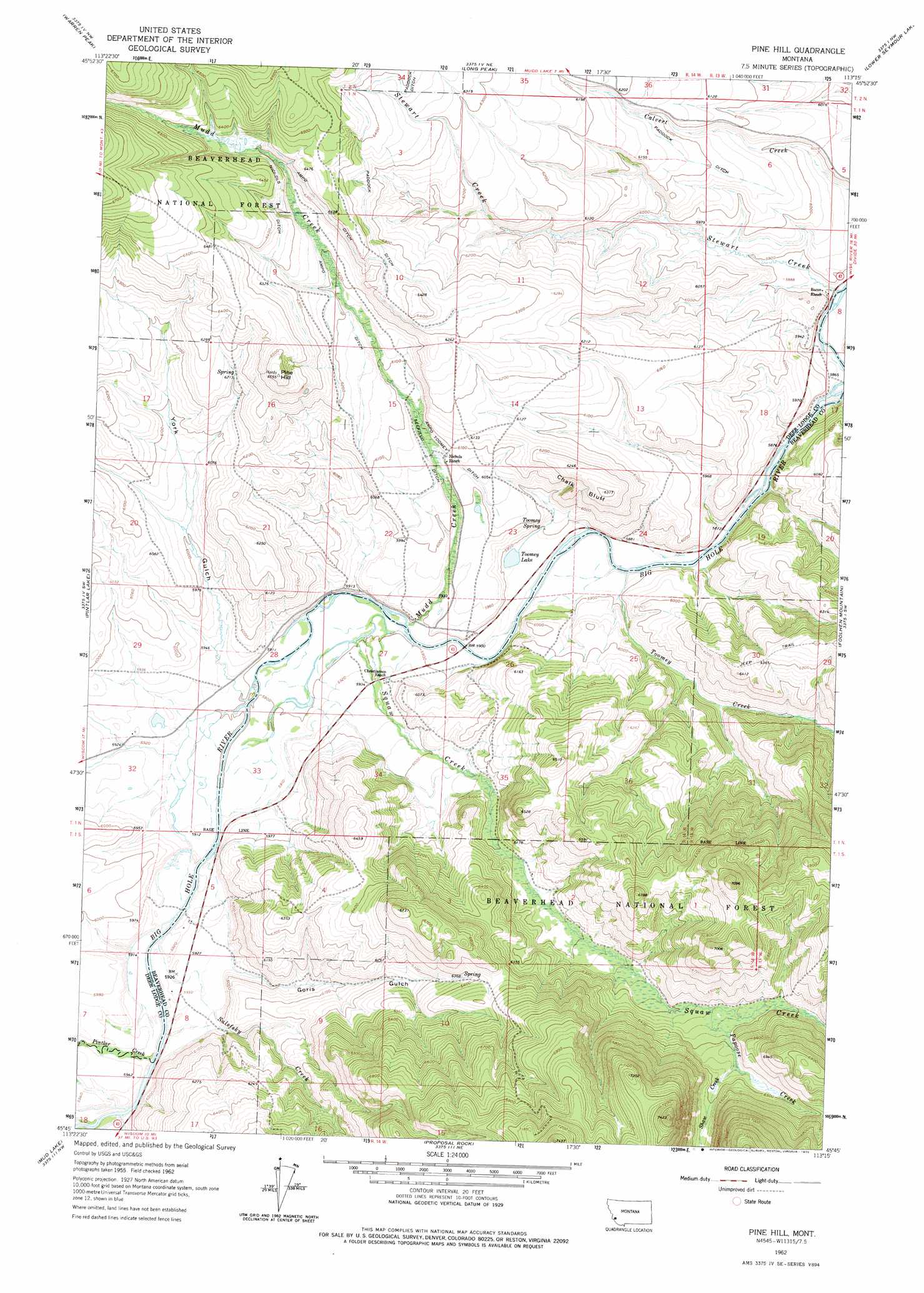
USGS Topo Quad 45113g3 - 1:24,000 scale
| Topo Map Name: | Pine Hill |
| USGS Topo Quad ID: | 45113g3 |
| Print Size: | ca. 21 1/4" wide x 27" high |
| Southeast Coordinates: | 45.75° N latitude / 113.25° W longitude |
| Map Center Coordinates: | 45.8125° N latitude / 113.3125° W longitude |
| U.S. State: | MT |
| Filename: | o45113g3.jpg |
| Download Map JPG Image: | Pine Hill topo map 1:24,000 scale |
| Map Type: | Topographic |
| Topo Series: | 7.5´ |
| Map Scale: | 1:24,000 |
| Source of Map Images: | United States Geological Survey (USGS) |
| Alternate Map Versions: |
Pine Hill MT 1962, updated 1964 Download PDF Buy paper map Pine Hill MT 1962, updated 1975 Download PDF Buy paper map Pine Hill MT 1997, updated 2002 Download PDF Buy paper map Pine Hill MT 2011 Download PDF Buy paper map Pine Hill MT 2014 Download PDF Buy paper map |
| FStopo: | US Forest Service topo Pine Hill is available: Download FStopo PDF Download FStopo TIF |
1:24,000 Topo Quads surrounding Pine Hill
Moose Lake |
Carpp Ridge |
Storm Lake |
Mount Evans |
Mount Haggin |
Kelly Lake |
Warren Peak |
Long Peak |
Lower Seymour Lake |
Lincoln Gulch |
Mussigbrod Lake |
Pintlar Lake |
Pine Hill |
Foolhen Mountain |
Dickie Hills |
Gibbons School |
Mud Lake |
Proposal Rock |
Shaw Mountain |
Stine Mountain |
Highland Ranch |
Wisdom |
Stewart Mountain |
Odell Lake |
Maurice Mountain |
> Back to 45113e1 at 1:100,000 scale
> Back to 45112a1 at 1:250,000 scale
> Back to U.S. Topo Maps home
Pine Hill topo map: Gazetteer
Pine Hill: Canals
Ampo Ditch elevation 1930m 6332′Ampo Toomey Ditch elevation 1843m 6046′
Nichols Ditch elevation 1934m 6345′
Seefield Ditch elevation 1845m 6053′
Pine Hill: Cliffs
Chalk Bluff elevation 1889m 6197′Pine Hill: Lakes
Toomey Lake elevation 1795m 5889′Pine Hill: Springs
Toomey Spring elevation 1806m 5925′Pine Hill: Streams
Christiansen Creek elevation 1799m 5902′Mudd Creek elevation 1796m 5892′
Papoose Creek elevation 1934m 6345′
Pintler Creek elevation 1800m 5905′
Salefsky Creek elevation 1800m 5905′
Sawlog Creek elevation 1792m 5879′
Shaw Creek elevation 1957m 6420′
Stewart Creek elevation 1786m 5859′
Toomey Creek elevation 1790m 5872′
Pine Hill: Summits
Pine Hill elevation 1999m 6558′Pine Hill: Valleys
Goris Gulch elevation 1811m 5941′York Gulch elevation 1805m 5921′
Pine Hill: Wells
01N14W15DDDD01 Well elevation 1843m 6046′Pine Hill digital topo map on disk
Buy this Pine Hill topo map showing relief, roads, GPS coordinates and other geographical features, as a high-resolution digital map file on DVD: