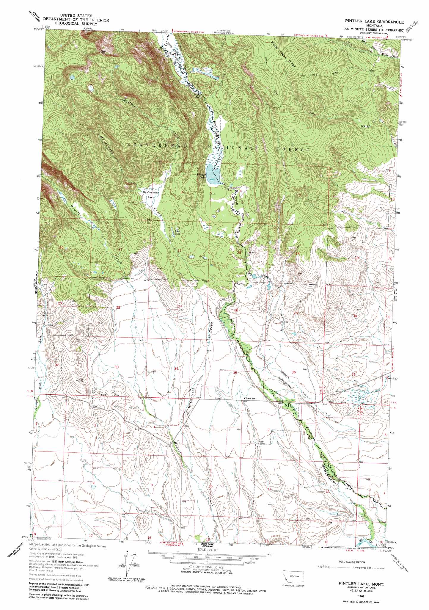
Pintlar Lake Topo Map Montana
To zoom in, hover over the map of Pintlar Lake
USGS Topo Quad 45113g4 - 1:24,000 scale
| Topo Map Name: | Pintlar Lake |
| USGS Topo Quad ID: | 45113g4 |
| Print Size: | ca. 21 1/4" wide x 27" high |
| Southeast Coordinates: | 45.75° N latitude / 113.375° W longitude |
| Map Center Coordinates: | 45.8125° N latitude / 113.4375° W longitude |
| U.S. State: | MT |
| Filename: | o45113g4.jpg |
| Download Map JPG Image: | Pintlar Lake topo map 1:24,000 scale |
| Map Type: | Topographic |
| Topo Series: | 7.5´ |
| Map Scale: | 1:24,000 |
| Source of Map Images: | United States Geological Survey (USGS) |
| Alternate Map Versions: |
Pintlar Lake MT 1962, updated 1964 Download PDF Buy paper map Pintler Lake MT 1962, updated 1985 Download PDF Buy paper map Pintler Lake MT 1997, updated 2002 Download PDF Buy paper map Pintler Lake MT 2011 Download PDF Buy paper map Pintler Lake MT 2014 Download PDF Buy paper map |
| FStopo: | US Forest Service topo Pintler Lake is available: Download FStopo PDF Download FStopo TIF |
1:24,000 Topo Quads surrounding Pintlar Lake
Whetstone Ridge |
Moose Lake |
Carpp Ridge |
Storm Lake |
Mount Evans |
Lick Creek |
Kelly Lake |
Warren Peak |
Long Peak |
Lower Seymour Lake |
Bender Point |
Mussigbrod Lake |
Pintlar Lake |
Pine Hill |
Foolhen Mountain |
Big Hole Battlefield |
Gibbons School |
Mud Lake |
Proposal Rock |
Shaw Mountain |
Isaac Meadows |
Highland Ranch |
Wisdom |
Stewart Mountain |
Odell Lake |
> Back to 45113e1 at 1:100,000 scale
> Back to 45112a1 at 1:250,000 scale
> Back to U.S. Topo Maps home
Pintlar Lake topo map: Gazetteer
Pintlar Lake: Canals
Big Bushong Ditch elevation 1902m 6240′Christenson Ditch elevation 1858m 6095′
Nyhart Ditch elevation 1887m 6190′
Sparrow Waste Ditch elevation 1859m 6099′
Pintlar Lake: Falls
Pintler Falls elevation 1956m 6417′Pintlar Lake: Flats
McCormick Park elevation 1962m 6437′Pintler Meadows elevation 1960m 6430′
Pintlar Lake: Lakes
Lion Lake elevation 1946m 6384′Pintler Lake elevation 1922m 6305′
Pintlar Lake: Post Offices
Bowen Post Office (historical) elevation 1831m 6007′Pintlar Lake: Streams
East Fork Mudd Creek elevation 1986m 6515′East Fork Thompson Creek elevation 1870m 6135′
McCormick Creek elevation 1841m 6040′
Roberts Creek elevation 1958m 6423′
West Fork Mudd Creek elevation 1986m 6515′
Pintlar Lake: Wells
01N15W14BCAA01 Well elevation 1926m 6318′01N15W34DADC01 Well elevation 1860m 6102′
01N15W34DDAB01 Well elevation 1870m 6135′
01N15W34DDAB02 Well elevation 1869m 6131′
01S15W02ADAC01 Well elevation 1847m 6059′
01S15W03BBCD01 Well elevation 1868m 6128′
01S15W03BCBA01 Well elevation 1867m 6125′
01S15W03BCBA02 Well elevation 1867m 6125′
01S15W04DACC01 Well elevation 1861m 6105′
01S15W08BADD01 Well elevation 1848m 6062′
Pintlar Lake digital topo map on disk
Buy this Pintlar Lake topo map showing relief, roads, GPS coordinates and other geographical features, as a high-resolution digital map file on DVD: