Cut Bank Se Topo Map Montana
To zoom in, hover over the map of Cut Bank Se
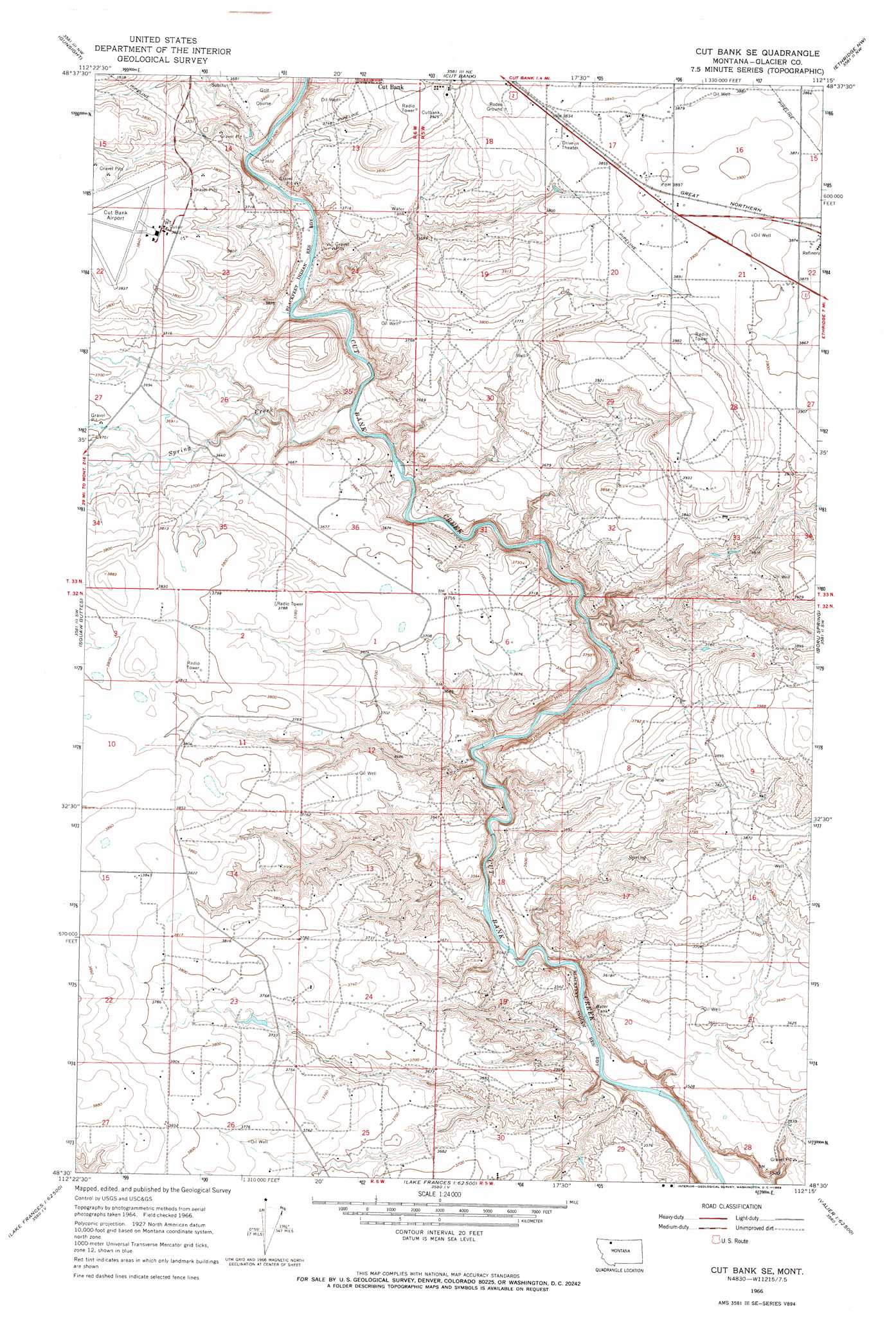
USGS Topo Quad 48112e3 - 1:24,000 scale
| Topo Map Name: | Cut Bank Se |
| USGS Topo Quad ID: | 48112e3 |
| Print Size: | ca. 21 1/4" wide x 27" high |
| Southeast Coordinates: | 48.5° N latitude / 112.25° W longitude |
| Map Center Coordinates: | 48.5625° N latitude / 112.3125° W longitude |
| U.S. State: | MT |
| Filename: | o48112e3.jpg |
| Download Map JPG Image: | Cut Bank Se topo map 1:24,000 scale |
| Map Type: | Topographic |
| Topo Series: | 7.5´ |
| Map Scale: | 1:24,000 |
| Source of Map Images: | United States Geological Survey (USGS) |
| Alternate Map Versions: |
Cut Bank SE MT 1966, updated 1969 Download PDF Buy paper map Cut Bank SE MT 2011 Download PDF Buy paper map Cut Bank SE MT 2014 Download PDF Buy paper map |
1:24,000 Topo Quads surrounding Cut Bank Se
Rocky Buttes |
Dead Indian Spring |
Headlight Butte |
Glacier Colony |
Mountain View School |
Sundance |
Gunsight |
Cut Bank |
Ethridge Nw |
Aloe |
Mission Lake East |
Squaw Buttes |
Cut Bank Se |
Boru Spring |
Ethridge |
Rocky Ridge |
Flag Butte |
Rock City |
Abbott Lake |
Cactus Flat |
Robere |
Kuka Crossing |
Valier West |
Valier East |
Belgian Hill |
> Back to 48112e1 at 1:100,000 scale
> Back to 48112a1 at 1:250,000 scale
> Back to U.S. Topo Maps home
Cut Bank Se topo map: Gazetteer
Cut Bank Se: Streams
Spring Creek elevation 1068m 3503′Cut Bank Se: Valleys
Spring Coulee elevation 1093m 3585′Cut Bank Se: Wells
32N05W16AACC01 Well elevation 1172m 3845′32N05W16BC__01 Well elevation 1164m 3818′
32N05W30BB__01 Well elevation 1096m 3595′
32N05W30BD__02 Well elevation 1091m 3579′
32N05W30BDDA01 Well elevation 1091m 3579′
32N05W30DC__01 Well elevation 1128m 3700′
32N06W01AC__01 Well elevation 1135m 3723′
32N06W24DA__01 Well elevation 1134m 3720′
32N06W25AD__01 Well elevation 1127m 3697′
33N05W17AD__01 Well elevation 1181m 3874′
33N05W17DA__01 Well elevation 1187m 3894′
33N05W17DA__02 Well elevation 1187m 3894′
33N05W19AB__01 Well elevation 1141m 3743′
33N05W20DA__01 Well elevation 1185m 3887′
33N05W21BB__01 Well elevation 1188m 3897′
33N05W21BBBD02 Well elevation 1188m 3897′
33N05W21BC__01 Well elevation 1190m 3904′
33N05W21DA__01 Well elevation 1189m 3900′
33N05W22BC__01 Well elevation 1178m 3864′
33N05W29CA__01 Well elevation 1160m 3805′
33N05W30AA__01 Well elevation 1146m 3759′
33N05W32AD__01 Well elevation 1164m 3818′
33N06W14CA__01 Well elevation 1161m 3809′
33N06W24BB__01 Well elevation 1102m 3615′
Cut Bank Se digital topo map on disk
Buy this Cut Bank Se topo map showing relief, roads, GPS coordinates and other geographical features, as a high-resolution digital map file on DVD: