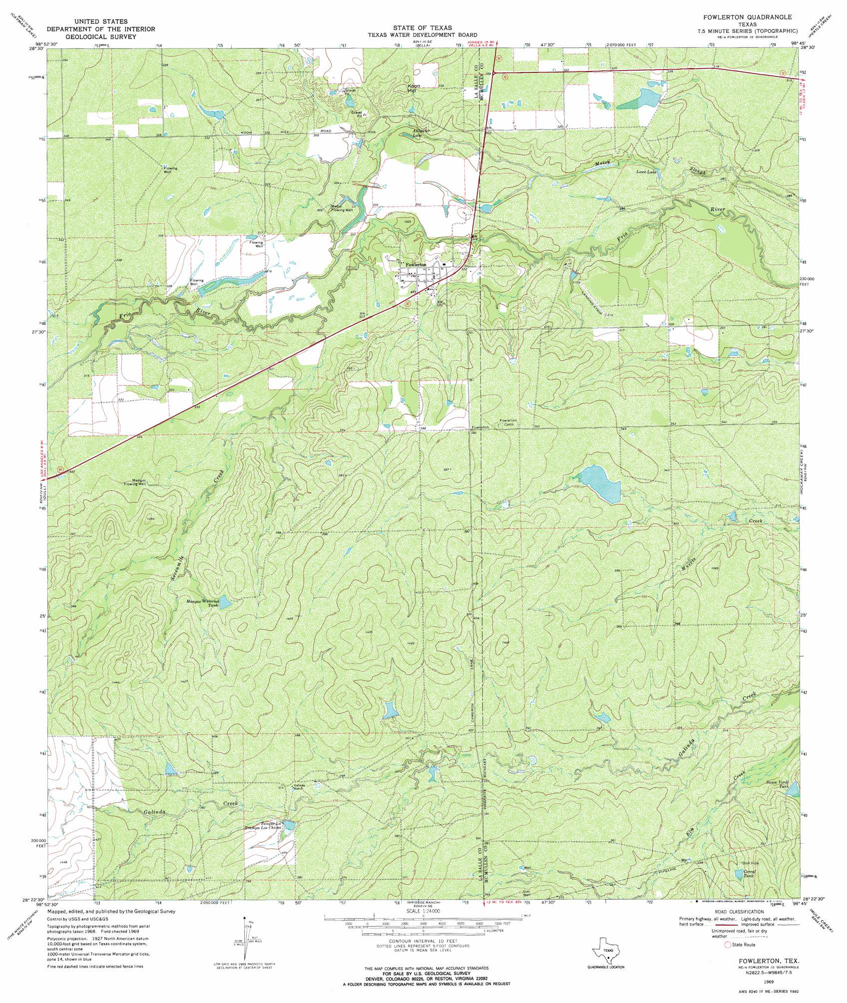
Fowlerton Topo Map Texas
To zoom in, hover over the map of Fowlerton
USGS Topo Quad 28098d7 - 1:24,000 scale
| Topo Map Name: | Fowlerton |
| USGS Topo Quad ID: | 28098d7 |
| Print Size: | ca. 21 1/4" wide x 27" high |
| Southeast Coordinates: | 28.375° N latitude / 98.75° W longitude |
| Map Center Coordinates: | 28.4375° N latitude / 98.8125° W longitude |
| U.S. State: | TX |
| Filename: | o28098d7.jpg |
| Download Map JPG Image: | Fowlerton topo map 1:24,000 scale |
| Map Type: | Topographic |
| Topo Series: | 7.5´ |
| Map Scale: | 1:24,000 |
| Source of Map Images: | United States Geological Survey (USGS) |
| Alternate Map Versions: |
Fowlerton TX 1969, updated 1972 Download PDF Buy paper map Fowlerton TX 2010 Download PDF Buy paper map Fowlerton TX 2013 Download PDF Buy paper map Fowlerton TX 2016 Download PDF Buy paper map |
1:24,000 Topo Quads surrounding Fowlerton
Dilley Ne |
Las Flores |
Hindes |
San Miguel Ranch |
Cross Ne |
Burns Ranch |
Cayman Lake |
Zella |
Pertle Creek |
Cross |
Los Angeles |
Dull |
Fowlerton |
Rockaway Creek |
Tilden |
Charco Marrano Creek |
The White Kitchen |
Briscoe Ranch |
Mule Creek |
Fitzpatrick Hollow |
Caiman Creek Ne |
Piedra Creek Nw |
Piedra Creek Ne |
Loma Alta Nw |
Loma Alta Ne |
> Back to 28098a1 at 1:100,000 scale
> Back to 28098a1 at 1:250,000 scale
> Back to U.S. Topo Maps home
Fowlerton topo map: Gazetteer
Fowlerton: Dams
Miller Dam elevation 95m 311′Montgomery Lake Dam elevation 94m 308′
Morton Lake Dam elevation 104m 341′
Fowlerton: Lakes
Alligator Lake elevation 91m 298′Lowe Lake elevation 87m 285′
Fowlerton: Populated Places
Fowlerton elevation 98m 321′Fowlerton: Reservoirs
Corral Tank elevation 108m 354′Mangas Waterlot Tank elevation 113m 370′
Miller Lake elevation 95m 311′
Montgomery Lake elevation 94m 308′
Morton Lake elevation 104m 341′
Sauce Verde Tank elevation 104m 341′
Tanque La Trampa Los Chivos elevation 119m 390′
Fowlerton: Streams
Sevenmile Creek elevation 91m 298′Fowlerton: Summits
Koon Hill elevation 107m 351′Fowlerton: Wells
Mangas Flowing Well elevation 104m 341′Medio Flowing Well elevation 92m 301′
Fowlerton digital topo map on disk
Buy this Fowlerton topo map showing relief, roads, GPS coordinates and other geographical features, as a high-resolution digital map file on DVD: