Bayou Blanc Topo Map Louisiana
To zoom in, hover over the map of Bayou Blanc
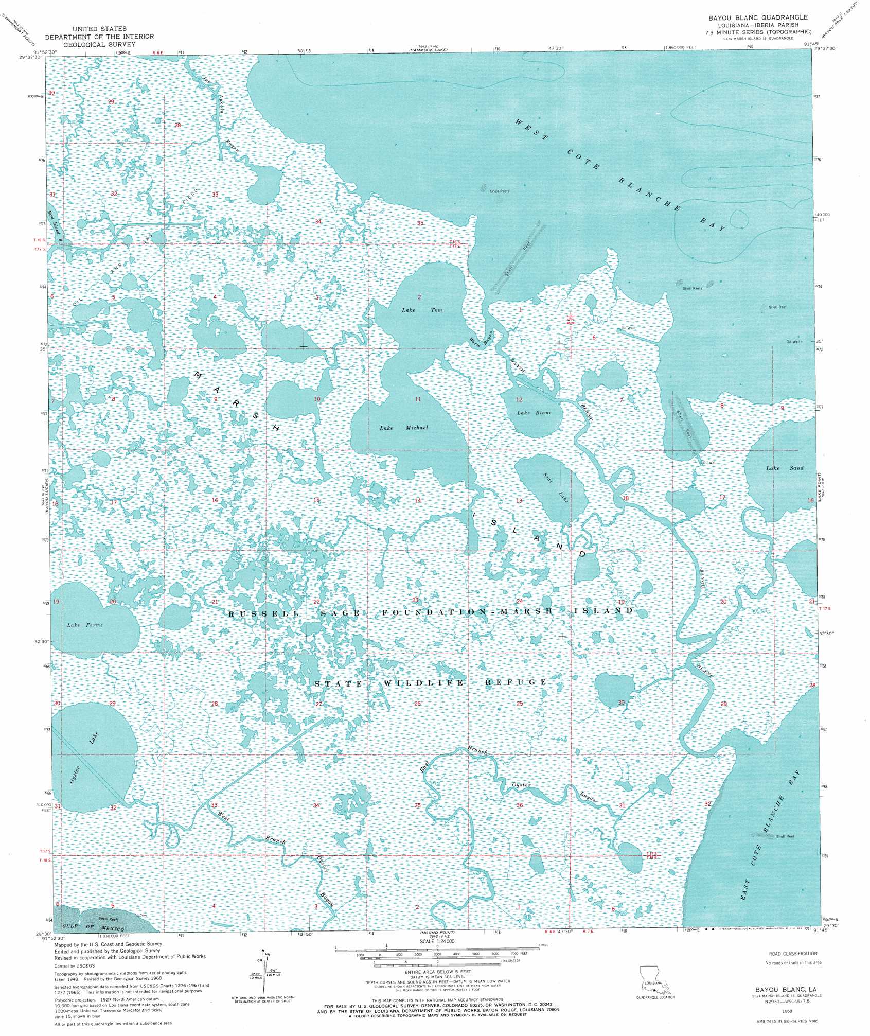
USGS Topo Quad 29091e7 - 1:24,000 scale
| Topo Map Name: | Bayou Blanc |
| USGS Topo Quad ID: | 29091e7 |
| Print Size: | ca. 21 1/4" wide x 27" high |
| Southeast Coordinates: | 29.5° N latitude / 91.75° W longitude |
| Map Center Coordinates: | 29.5625° N latitude / 91.8125° W longitude |
| U.S. State: | LA |
| Filename: | o29091e7.jpg |
| Download Map JPG Image: | Bayou Blanc topo map 1:24,000 scale |
| Map Type: | Topographic |
| Topo Series: | 7.5´ |
| Map Scale: | 1:24,000 |
| Source of Map Images: | United States Geological Survey (USGS) |
| Alternate Map Versions: |
Bayou Blanc LA 1948, updated 1952 Download PDF Buy paper map Bayou Blanc LA 1948, updated 1958 Download PDF Buy paper map Bayou Blanc LA 1968, updated 1969 Download PDF Buy paper map Bayou Blanc LA 1999, updated 2003 Download PDF Buy paper map Bayou Blanc LA 2012 Download PDF Buy paper map Bayou Blanc LA 2015 Download PDF Buy paper map |
1:24,000 Topo Quads surrounding Bayou Blanc
Hebert Lake |
Tigre Lagoon |
Weeks |
Kemper |
Franklin |
Redfish Point |
Cypremort Point |
Hammock Lake |
Marone Point |
Ellerslie |
Hell Hole Bayou |
Bayou Lucien |
Bayou Blanc |
Lake Point |
Point Chevreuil |
Mound Point |
||||
> Back to 29091e1 at 1:100,000 scale
> Back to 29090a1 at 1:250,000 scale
> Back to U.S. Topo Maps home
Bayou Blanc topo map: Gazetteer
Bayou Blanc: Bays
Worm Cove elevation 0m 0′Bayou Blanc: Capes
Worm Point elevation 0m 0′Bayou Blanc: Guts
East Branch Oyster Bayou elevation 0m 0′Joe Aucoin Bayou elevation 0m 0′
West Branch Oyster Bayou elevation 0m 0′
Worm Bayou elevation 0m 0′
Bayou Blanc: Islands
Marsh Island elevation 0m 0′Bayou Blanc: Lakes
Lake Blanc elevation 0m 0′Lake Ferme elevation 0m 0′
Lake Michael elevation 0m 0′
Lake Sand elevation 0m 0′
Lake Tom elevation 0m 0′
Oyster Lake elevation 0m 0′
Scat Lake elevation 0m 0′
Bayou Blanc: Parks
Russell Sage Foundation-Marsh Island State Wildlife Refuge elevation 0m 0′Bayou Blanc: Streams
Bayou Blanc elevation 0m 0′Bayou Blanc digital topo map on disk
Buy this Bayou Blanc topo map showing relief, roads, GPS coordinates and other geographical features, as a high-resolution digital map file on DVD: