Little Lost River Sinks Topo Map Idaho
To zoom in, hover over the map of Little Lost River Sinks
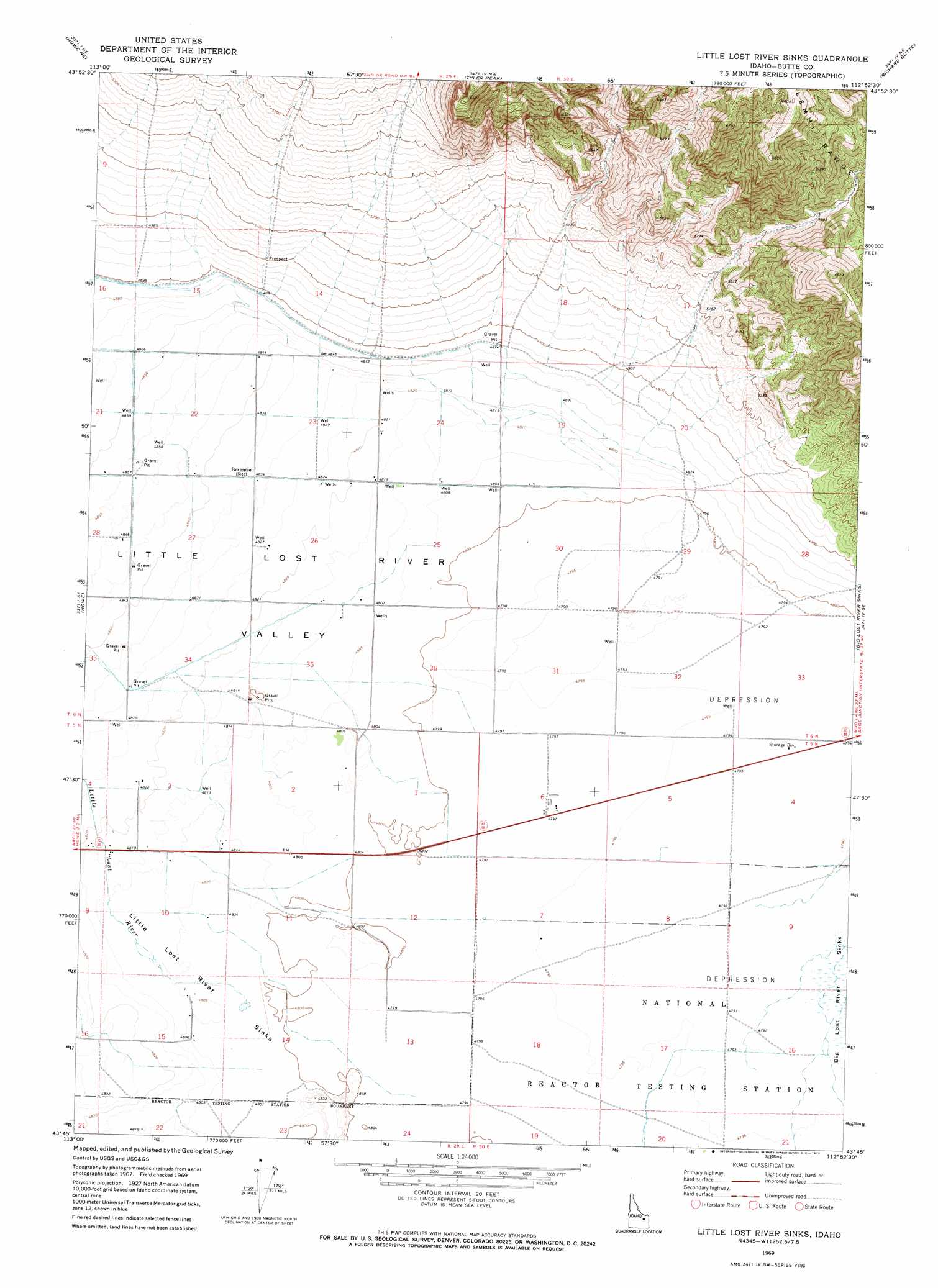
USGS Topo Quad 43112g8 - 1:24,000 scale
| Topo Map Name: | Little Lost River Sinks |
| USGS Topo Quad ID: | 43112g8 |
| Print Size: | ca. 21 1/4" wide x 27" high |
| Southeast Coordinates: | 43.75° N latitude / 112.875° W longitude |
| Map Center Coordinates: | 43.8125° N latitude / 112.9375° W longitude |
| U.S. State: | ID |
| Filename: | o43112g8.jpg |
| Download Map JPG Image: | Little Lost River Sinks topo map 1:24,000 scale |
| Map Type: | Topographic |
| Topo Series: | 7.5´ |
| Map Scale: | 1:24,000 |
| Source of Map Images: | United States Geological Survey (USGS) |
| Alternate Map Versions: |
Little Lost River Sinks ID 1969, updated 1973 Download PDF Buy paper map Little Lost River Sinks ID 2010 Download PDF Buy paper map Little Lost River Sinks ID 2013 Download PDF Buy paper map |
1:24,000 Topo Quads surrounding Little Lost River Sinks
Badger Creek |
Fallert Springs |
Eightmile Canyon |
Scott Butte |
Snaky Canyon |
Howe Nw |
Howe Ne |
Tyler Peak |
Richard Butte |
Circular Butte Nw |
Arco Pass |
Howe |
Little Lost River Sinks |
Big Lost River Sinks |
Circular Butte |
Arco Hills |
Howe Peak |
Circular Butte 3 Nw |
Circular Butte 3 Ne |
Little Butte Nw |
Butte City |
Arco Hills Se |
Circular Butte 3 Sw |
Circular Butte 3 Se |
Little Butte Sw |
> Back to 43112e1 at 1:100,000 scale
> Back to 43112a1 at 1:250,000 scale
> Back to U.S. Topo Maps home
Little Lost River Sinks topo map: Gazetteer
Little Lost River Sinks: Basins
Little Lost River Sinks elevation 1466m 4809′Little Lost River Sinks: Populated Places
Berenice elevation 1474m 4835′Sweet Sage (historical) elevation 1465m 4806′
Little Lost River Sinks: Streams
Little Lost River elevation 1465m 4806′Little Lost River Sinks: Valleys
Little Lost River Valley elevation 1463m 4799′Little Lost River Sinks digital topo map on disk
Buy this Little Lost River Sinks topo map showing relief, roads, GPS coordinates and other geographical features, as a high-resolution digital map file on DVD: