Drummond Topo Map Michigan
To zoom in, hover over the map of Drummond
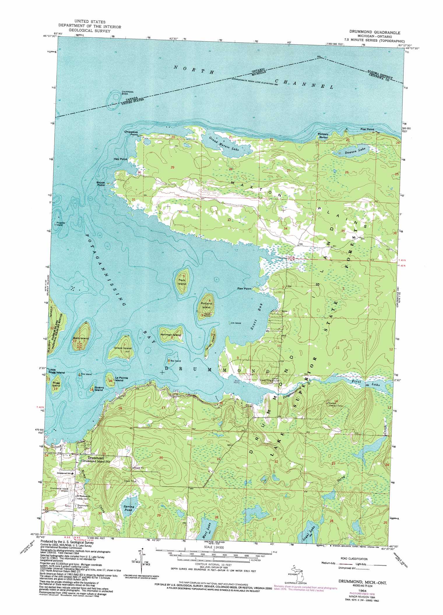
USGS Topo Quad 46083a6 - 1:24,000 scale
| Topo Map Name: | Drummond |
| USGS Topo Quad ID: | 46083a6 |
| Print Size: | ca. 21 1/4" wide x 27" high |
| Southeast Coordinates: | 46° N latitude / 83.625° W longitude |
| Map Center Coordinates: | 46.0625° N latitude / 83.6875° W longitude |
| U.S. State: | MI |
| Filename: | o46083a6.jpg |
| Download Map JPG Image: | Drummond topo map 1:24,000 scale |
| Map Type: | Topographic |
| Topo Series: | 7.5´ |
| Map Scale: | 1:24,000 |
| Source of Map Images: | United States Geological Survey (USGS) |
| Alternate Map Versions: |
Drummond MI 1964, updated 1965 Download PDF Buy paper map Drummond MI 1964, updated 1978 Download PDF Buy paper map Drummond MI 1964, updated 1994 Download PDF Buy paper map Drummond MI 2011 Download PDF Buy paper map Drummond MI 2014 Download PDF Buy paper map Drummond MI 2016 Download PDF Buy paper map |
1:24,000 Topo Quads surrounding Drummond
Lime Island |
Burnt Island |
Drummond |
Drummond Se |
|
De Tour Village |
Whitney Bay |
Meade Island |
Marble Head |
|
> Back to 46083a1 at 1:100,000 scale
> Back to 46082a1 at 1:250,000 scale
> Back to U.S. Topo Maps home
Drummond topo map: Gazetteer
Drummond: Airports
Ashman Island Seaplane Base elevation 177m 580′Drummond Island Airport elevation 201m 659′
Drummond: Bars
Chippewa Bank elevation 176m 577′Drummond: Bays
Grand Marais Lake elevation 177m 580′Scott Bay elevation 177m 580′
Walkters Harbor elevation 177m 580′
Drummond: Capes
Bruce Point elevation 177m 580′Chippewa Point elevation 178m 583′
Hay Point elevation 177m 580′
Paw Point elevation 179m 587′
Poe Point elevation 177m 580′
Drummond: Flats
Maxton Plains elevation 186m 610′Drummond: Islands
Ashman Island elevation 180m 590′Bald Island elevation 195m 639′
Bay Island elevation 178m 583′
Drummond Island elevation 206m 675′
Fire Island elevation 179m 587′
Grape Island elevation 188m 616′
James Island elevation 180m 590′
Jim Island elevation 177m 580′
La Pointe Island elevation 183m 600′
Little Rogg Island elevation 180m 590′
Peck Island elevation 189m 620′
Propeller Island elevation 177m 580′
Quarry Island elevation 180m 590′
Rogg Island elevation 177m 580′
Rutland Island elevation 193m 633′
Drummond: Lakes
Dawson Lake elevation 180m 590′Loyal Lake elevation 202m 662′
Spring Pond elevation 201m 659′
Drummond: Levees
Chippewa Bank elevation 177m 580′Drummond: Parks
Betsy Seamon Memorial Park elevation 181m 593′Drummond: Populated Places
Drummond elevation 189m 620′Maxton elevation 183m 600′
Drummond: Post Offices
Drummond Island Post Office elevation 186m 610′Maxton Post Office (historical) elevation 183m 600′
Drummond: Streams
Kemp Creek elevation 179m 587′Potagannissing River elevation 177m 580′
Stony Creek elevation 177m 580′
Drummond digital topo map on disk
Buy this Drummond topo map showing relief, roads, GPS coordinates and other geographical features, as a high-resolution digital map file on DVD:
 map DVD")