Murphy Topo Map Idaho
To zoom in, hover over the map of Murphy
USGS Topo Map 43116a1 - 1:100,000 scale
| Topo Map Name: | Murphy |
| USGS Topo Quad ID: | 43116a1 |
| Print Size: | ca. 39" wide x 24" high |
| Southeast Coordinates: | 43° N latitude / 116° W longitude |
| Map Center Coordinates: | 43.25° N latitude / 116.5° W longitude |
| U.S. State: | ID |
| Filename: | 43116a1.jpg |
| Download Map JPG Image: | Murphy topo map 1:100,000 scale |
| Map Type: | Topographic |
| Topo Series: | 30´x60´ |
| Map Scale: | 1:100,000 |
| Source of Map Images: | United States Geological Survey (USGS) |
| Alternate Map Versions: |
Murphy ID 1986, updated 1986 Download PDF Buy paper map |
1:100,000 Topos surrounding Murphy
Vale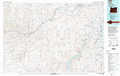 |
Boise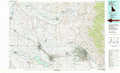 |
Idaho City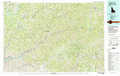 |
Mahogany Mountain |
Murphy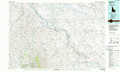 |
Mountain Home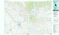 |
Jordan Valley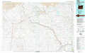 |
Triangle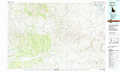 |
Glenns Ferry |
> Back to 43116a1 at 1:250,000 scale
> Back to U.S. Topo Maps home
1:24,000 Topo Quads covered by the spatial extent of this 100k map (Murphy)
|
Jump Creek Canyon 
|
Opalene Gulch 
|
Givens Hot Springs 
|
Melba 
|
Kuna 
|
Mora 
|
Owyhee 
|
Indian Creek Reservoir 
|
|
Piute Butte 
|
Soldier Cap 
|
Wilson Peak 
|
Walters Butte 
|
Initial Point 
|
Coyote Butte 
|
Christmas Mountain 
|
Orchard 
|
|
Captain Butte 
|
Rooster Comb Peak 
|
Reynolds 
|
Murphy 
|
Sinker Butte 
|
Wild Horse Butte 
|
Big Foot Butte 
|
Little Joe Butte 
|
|
Swisher Mountain 
|
De Lamar 
|
Silver City 
|
Sinker Canyon 
|
Oreana 
|
Castle Butte 
|
Jackass Butte 
|
Dorsey Butte 
|
