Bayou Current Topo Map Louisiana
To zoom in, hover over the map of Bayou Current
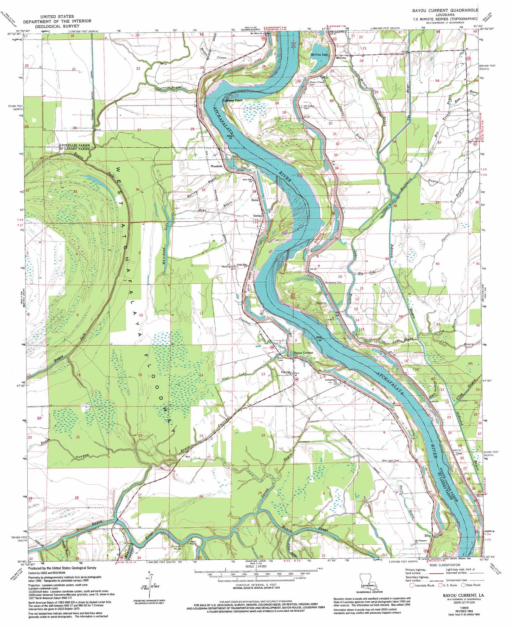
USGS Topo Quad 30091g7 - 1:24,000 scale
| Topo Map Name: | Bayou Current |
| USGS Topo Quad ID: | 30091g7 |
| Print Size: | ca. 21 1/4" wide x 27" high |
| Southeast Coordinates: | 30.75° N latitude / 91.75° W longitude |
| Map Center Coordinates: | 30.8125° N latitude / 91.8125° W longitude |
| U.S. State: | LA |
| Filename: | o30091g7.jpg |
| Download Map JPG Image: | Bayou Current topo map 1:24,000 scale |
| Map Type: | Topographic |
| Topo Series: | 7.5´ |
| Map Scale: | 1:24,000 |
| Source of Map Images: | United States Geological Survey (USGS) |
| Alternate Map Versions: |
Bayou Current LA 1969, updated 1971 Download PDF Buy paper map Bayou Current LA 1969, updated 1994 Download PDF Buy paper map Bayou Current LA 1998, updated 2002 Download PDF Buy paper map Bayou Current LA 2012 Download PDF Buy paper map Bayou Current LA 2015 Download PDF Buy paper map |
1:24,000 Topo Quads surrounding Bayou Current
Marksville South |
Moreauville |
Big Bend |
Turnbull Island |
Fort Adams |
Cottonport |
Plaucheville |
Simmesport |
Innis |
Tunica |
Morrow |
Bayou Jack |
Bayou Current |
Batchelor |
Lacour |
Beggs |
Palmetto |
Swayze Lake |
Melville |
Morganza |
Opelousas |
Port Barre |
Krotz Springs |
Lottie |
Fordoche |
> Back to 30091e1 at 1:100,000 scale
> Back to 30090a1 at 1:250,000 scale
> Back to U.S. Topo Maps home
Bayou Current topo map: Gazetteer
Bayou Current: Canals
Johnson Bayou elevation 6m 19′The Bays elevation 10m 32′
Bayou Current: Capes
Cypress Point elevation 7m 22′Bayou Current: Flats
West Atchafalaya Floodway elevation 11m 36′Bayou Current: Guts
Castel Bayou elevation 11m 36′Davis Bayou elevation 10m 32′
East Prong Lake Bayou elevation 11m 36′
Lake Bayou elevation 9m 29′
Bayou Current: Lakes
Greens Lake elevation 7m 22′McCrea Lake elevation 9m 29′
Whitehead Lake elevation 9m 29′
Bayou Current: Oilfields
Elba Oil Field elevation 8m 26′Quinton Oil Field elevation 10m 32′
Bayou Current: Populated Places
Bayou Current elevation 12m 39′Coon elevation 10m 32′
Delano (historical) elevation 10m 32′
Elba elevation 11m 36′
Gordon elevation 12m 39′
McCrea elevation 16m 52′
Neita elevation 11m 36′
Somers (historical) elevation 12m 39′
Suna elevation 12m 39′
Webb (historical) elevation 10m 32′
Woodside elevation 13m 42′
Bayou Current: Streams
Bayou Current elevation 8m 26′Bayou Garwood elevation 10m 32′
Bayou Tawpaw elevation 5m 16′
Bee Tree Bayou elevation 6m 19′
Buckhorn Bayou elevation 6m 19′
Coyles Bayou elevation 10m 32′
Crooked Bayou elevation 9m 29′
Flat Lake elevation 12m 39′
Harvey Bayou elevation 8m 26′
Hog Lake elevation 9m 29′
Hops Bayou elevation 8m 26′
Knee Bayou elevation 11m 36′
Middle Bayou elevation 7m 22′
Squaw Bayou elevation 6m 19′
Starks Bayou elevation 9m 29′
Turners Bayou elevation 7m 22′
Bayou Current digital topo map on disk
Buy this Bayou Current topo map showing relief, roads, GPS coordinates and other geographical features, as a high-resolution digital map file on DVD: