Longville Topo Map Louisiana
To zoom in, hover over the map of Longville
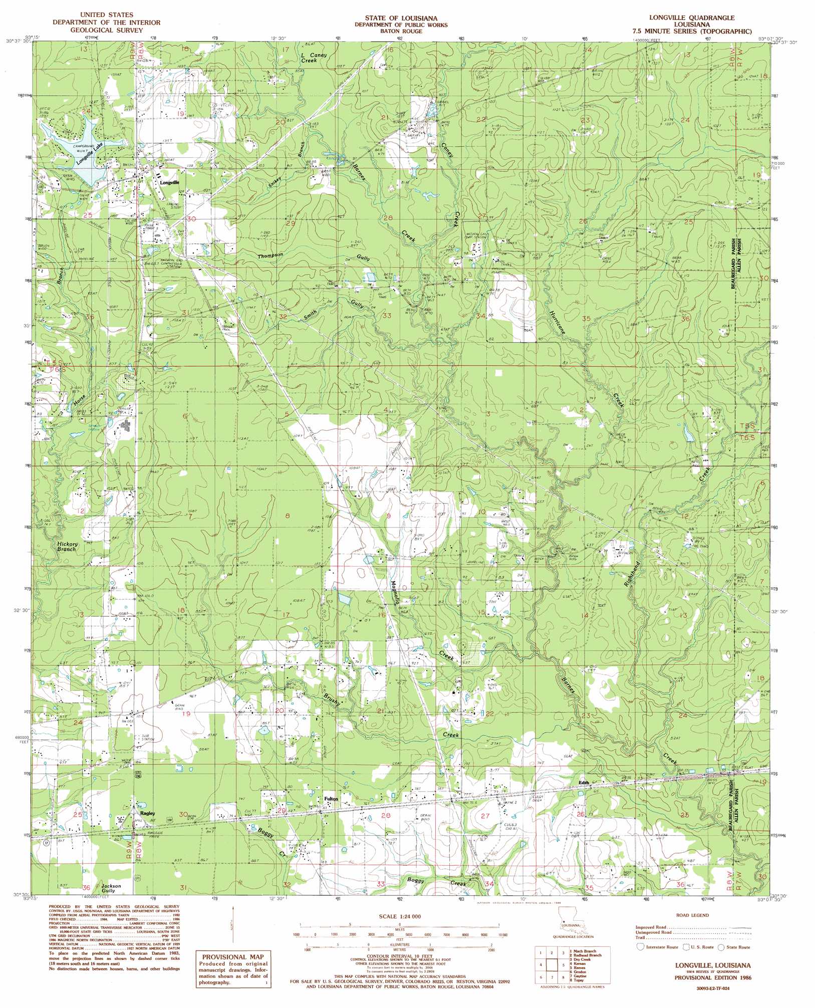
USGS Topo Quad 30093e2 - 1:24,000 scale
| Topo Map Name: | Longville |
| USGS Topo Quad ID: | 30093e2 |
| Print Size: | ca. 21 1/4" wide x 27" high |
| Southeast Coordinates: | 30.5° N latitude / 93.125° W longitude |
| Map Center Coordinates: | 30.5625° N latitude / 93.1875° W longitude |
| U.S. State: | LA |
| Filename: | o30093e2.jpg |
| Download Map JPG Image: | Longville topo map 1:24,000 scale |
| Map Type: | Topographic |
| Topo Series: | 7.5´ |
| Map Scale: | 1:24,000 |
| Source of Map Images: | United States Geological Survey (USGS) |
| Alternate Map Versions: |
Longville LA 1986, updated 1986 Download PDF Buy paper map Longville LA 1994, updated 1997 Download PDF Buy paper map Longville LA 2012 Download PDF Buy paper map Longville LA 2015 Download PDF Buy paper map |
1:24,000 Topo Quads surrounding Longville
Neale |
De Ridder |
Boneset Creek |
Sugartown |
Grant |
Singer |
Mach Branch |
Redhead Branch |
Dry Creek |
Mittie |
Oretta |
Kernan |
Longville |
Reeves |
Le Blanc |
De Quincy |
Gordon |
Gaytine |
Topsy |
Indian Village |
Brimstone |
Buhler |
Moss Bluff |
Hecker |
Fenton |
> Back to 30093e1 at 1:100,000 scale
> Back to 30092a1 at 1:250,000 scale
> Back to U.S. Topo Maps home
Longville topo map: Gazetteer
Longville: Oilfields
Clear Creek Oil Field elevation 23m 75′Hurricane Creek Oil Field elevation 27m 88′
Righthand Creek Oil Field elevation 33m 108′
Longville: Populated Places
Edith elevation 18m 59′Fayette (historical) elevation 33m 108′
Fulton elevation 24m 78′
Longville elevation 40m 131′
Ragley elevation 28m 91′
Longville: Post Offices
Longville Post Office elevation 40m 131′Ragley Post Office elevation 24m 78′
Longville: Reservoirs
Longville Lake elevation 33m 108′Longville: Streams
Brushy Creek elevation 14m 45′Caney Creek elevation 20m 65′
Horse Branch elevation 22m 72′
Hurricane Creek elevation 19m 62′
Little Caney Creek elevation 24m 78′
Magnolia Creek elevation 14m 45′
Righthand Creek elevation 14m 45′
Smith Gully elevation 17m 55′
Snikey Branch elevation 25m 82′
Thompson Gully elevation 22m 72′
Longville digital topo map on disk
Buy this Longville topo map showing relief, roads, GPS coordinates and other geographical features, as a high-resolution digital map file on DVD: