Shell Mountains Topo Map Texas
To zoom in, hover over the map of Shell Mountains
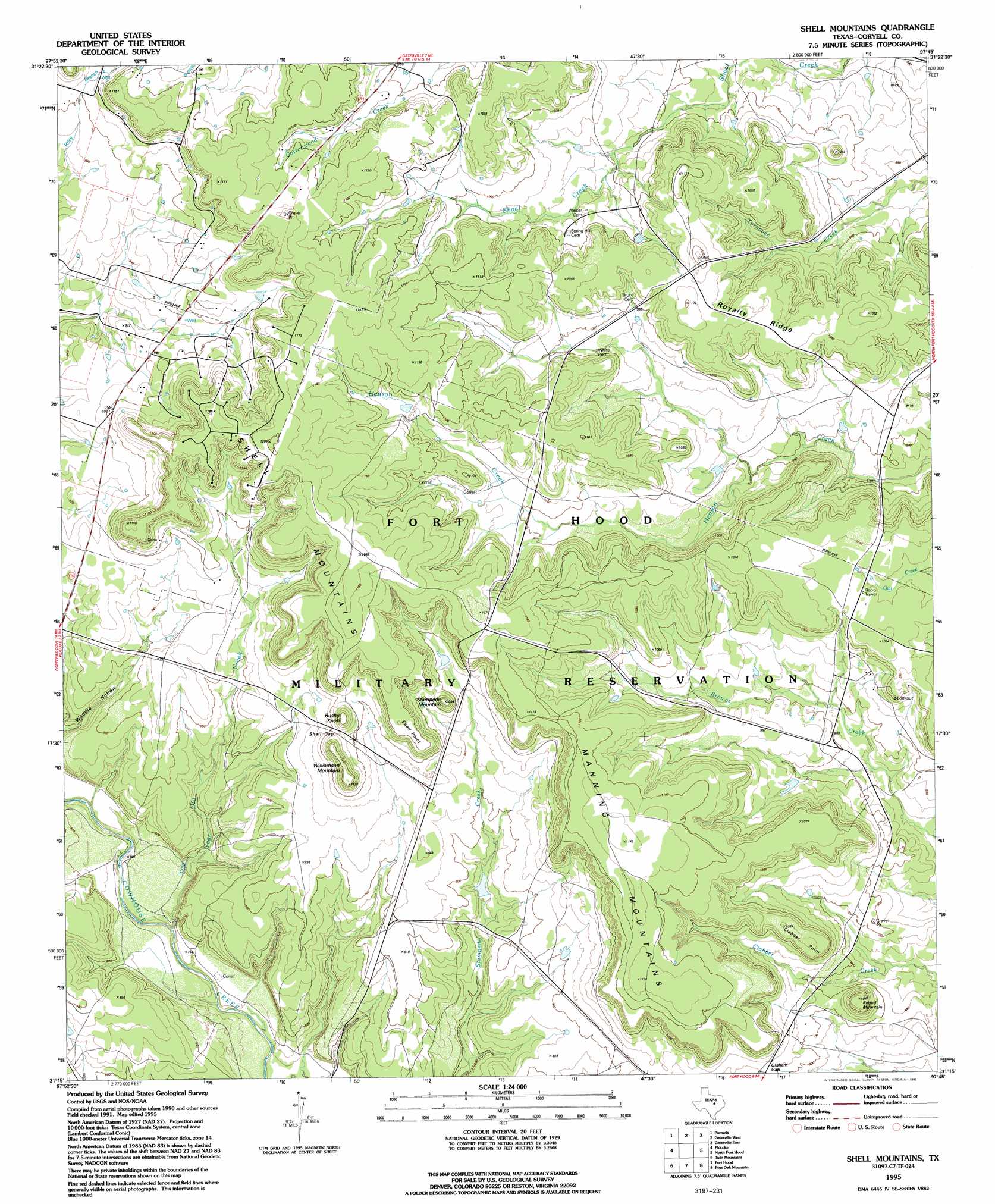
USGS Topo Quad 31097c7 - 1:24,000 scale
| Topo Map Name: | Shell Mountains |
| USGS Topo Quad ID: | 31097c7 |
| Print Size: | ca. 21 1/4" wide x 27" high |
| Southeast Coordinates: | 31.25° N latitude / 97.75° W longitude |
| Map Center Coordinates: | 31.3125° N latitude / 97.8125° W longitude |
| U.S. State: | TX |
| Filename: | o31097c7.jpg |
| Download Map JPG Image: | Shell Mountains topo map 1:24,000 scale |
| Map Type: | Topographic |
| Topo Series: | 7.5´ |
| Map Scale: | 1:24,000 |
| Source of Map Images: | United States Geological Survey (USGS) |
| Alternate Map Versions: |
Shell Mountains TX 1947, updated 1953 Download PDF Buy paper map Shell Mountains TX 1958, updated 1961 Download PDF Buy paper map Shell Mountains TX 1995, updated 1995 Download PDF Buy paper map Shell Mountains TX 2010 Download PDF Buy paper map Shell Mountains TX 2012 Download PDF Buy paper map Shell Mountains TX 2016 Download PDF Buy paper map |
1:24,000 Topo Quads surrounding Shell Mountains
Ohio |
Jonesboro |
Ater |
Turnersville |
Coryell |
Pearl |
Purmela |
Gatesville West |
Gatesville East |
Oglesby |
Izoro |
Pidcoke |
Shell Mountains |
North Fort Hood |
Leon Junction |
Rumley |
Twin Mountains |
Fort Hood |
Post Oak Mountain |
Bland |
Kempner |
Copperas Cove |
Mcmillan Mountains |
Killeen |
Nolanville |
> Back to 31097a1 at 1:100,000 scale
> Back to 31096a1 at 1:250,000 scale
> Back to U.S. Topo Maps home
Shell Mountains topo map: Gazetteer
Shell Mountains: Capes
Clabber Point elevation 324m 1062′Shell Point elevation 337m 1105′
Shell Mountains: Dams
Henson Lake Dam elevation 323m 1059′Ironhorse Park Lake Dam elevation 303m 994′
Shell Mountains: Gaps
Graham Gap elevation 281m 921′Shell Gap elevation 311m 1020′
Shell Mountains: Reservoirs
Henson Lake elevation 323m 1059′Ironhorse Park Lake elevation 303m 994′
Shell Mountains: Ridges
Royalty Ridge elevation 323m 1059′Shell Mountains: Streams
Two Year Old Creek elevation 221m 725′Shell Mountains: Summits
Bushy Knob elevation 337m 1105′Manning Mountains elevation 349m 1145′
Round Mountain elevation 319m 1046′
Shell Mountains elevation 361m 1184′
Stampede Mountan elevation 332m 1089′
Williamson Mountain elevation 340m 1115′
Shell Mountains digital topo map on disk
Buy this Shell Mountains topo map showing relief, roads, GPS coordinates and other geographical features, as a high-resolution digital map file on DVD: