Gatesville East Topo Map Texas
To zoom in, hover over the map of Gatesville East
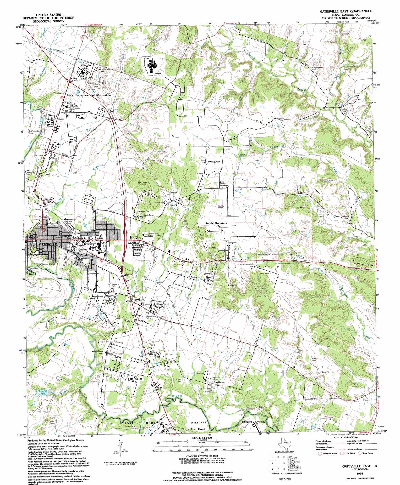
USGS Topo Quad 31097d6 - 1:24,000 scale
| Topo Map Name: | Gatesville East |
| USGS Topo Quad ID: | 31097d6 |
| Print Size: | ca. 21 1/4" wide x 27" high |
| Southeast Coordinates: | 31.375° N latitude / 97.625° W longitude |
| Map Center Coordinates: | 31.4375° N latitude / 97.6875° W longitude |
| U.S. State: | TX |
| Filename: | o31097d6.jpg |
| Download Map JPG Image: | Gatesville East topo map 1:24,000 scale |
| Map Type: | Topographic |
| Topo Series: | 7.5´ |
| Map Scale: | 1:24,000 |
| Source of Map Images: | United States Geological Survey (USGS) |
| Alternate Map Versions: |
Gatesville East TX 1947, updated 1953 Download PDF Buy paper map Gatesville East TX 1957, updated 1961 Download PDF Buy paper map Gatesville East TX 1957, updated 1979 Download PDF Buy paper map Gatesville East TX 1994, updated 1995 Download PDF Buy paper map Gatesville East TX 2010 Download PDF Buy paper map Gatesville East TX 2012 Download PDF Buy paper map Gatesville East TX 2016 Download PDF Buy paper map |
1:24,000 Topo Quads surrounding Gatesville East
Cutoff Mountain |
German Valley |
Hurst Spring |
Mosheim |
Valley Mills |
Jonesboro |
Ater |
Turnersville |
Coryell |
Crawford |
Purmela |
Gatesville West |
Gatesville East |
Oglesby |
Mcgregor |
Pidcoke |
Shell Mountains |
North Fort Hood |
Leon Junction |
Eagle Springs |
Twin Mountains |
Fort Hood |
Post Oak Mountain |
Bland |
Moffat |
> Back to 31097a1 at 1:100,000 scale
> Back to 31096a1 at 1:250,000 scale
> Back to U.S. Topo Maps home
Gatesville East topo map: Gazetteer
Gatesville East: Dams
Kercho Lake Dam elevation 221m 725′Peni-Bilt Dam elevation 228m 748′
Gatesville East: Parks
Fauntleroy Park elevation 224m 734′Fort Gates elevation 232m 761′
Raby Park elevation 238m 780′
Gatesville East: Populated Places
Fort Gates elevation 238m 780′Gatesville elevation 246m 807′
South Mountain elevation 311m 1020′
Gatesville East: Reservoirs
Kercho Lake elevation 221m 725′Peni-Bilt Lake elevation 238m 780′
Gatesville East: Streams
Clear Creek elevation 238m 780′Fourmile Branch elevation 226m 741′
Shoal Creek elevation 214m 702′
Turnover Creek elevation 214m 702′
Gatesville East digital topo map on disk
Buy this Gatesville East topo map showing relief, roads, GPS coordinates and other geographical features, as a high-resolution digital map file on DVD: