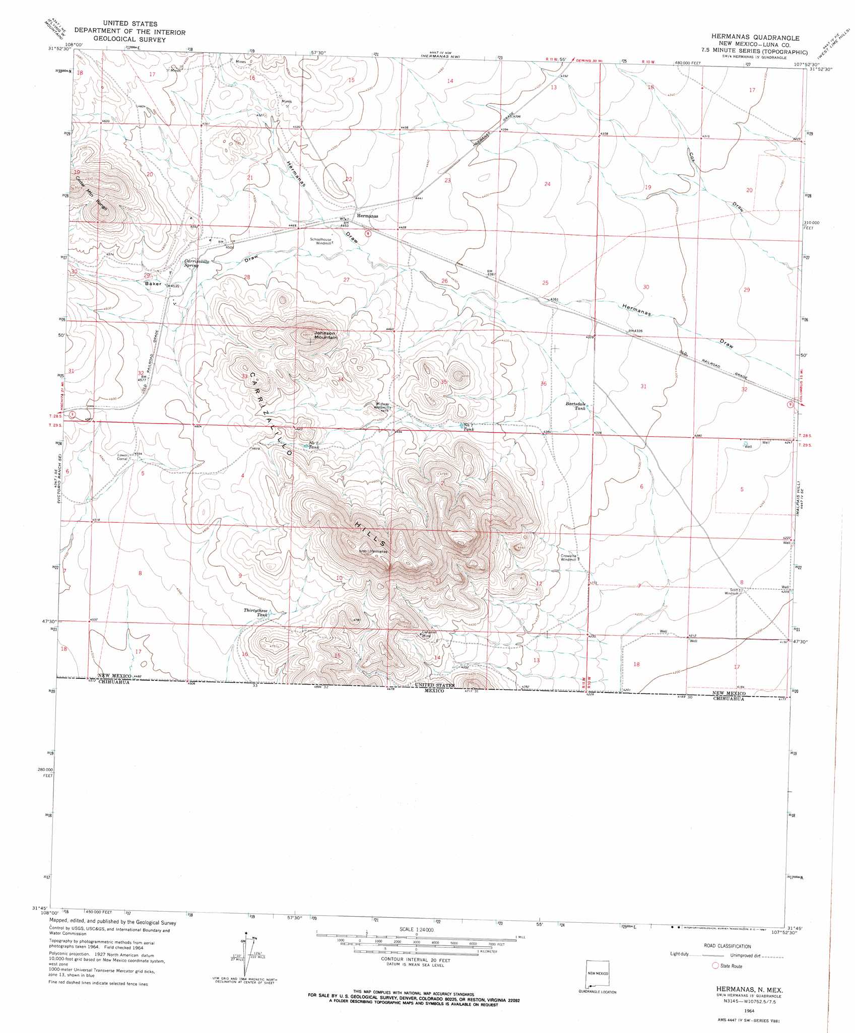
Hermanas Topo Map New Mexico
To zoom in, hover over the map of Hermanas
USGS Topo Quad 31107g8 - 1:24,000 scale
| Topo Map Name: | Hermanas |
| USGS Topo Quad ID: | 31107g8 |
| Print Size: | ca. 21 1/4" wide x 27" high |
| Southeast Coordinates: | 31.75° N latitude / 107.875° W longitude |
| Map Center Coordinates: | 31.8125° N latitude / 107.9375° W longitude |
| U.S. State: | NM |
| Filename: | o31107g8.jpg |
| Download Map JPG Image: | Hermanas topo map 1:24,000 scale |
| Map Type: | Topographic |
| Topo Series: | 7.5´ |
| Map Scale: | 1:24,000 |
| Source of Map Images: | United States Geological Survey (USGS) |
| Alternate Map Versions: |
Hermanas NM 1964, updated 1967 Download PDF Buy paper map Hermanas NM 2010 Download PDF Buy paper map Hermanas NM 2013 Download PDF Buy paper map Hermanas NM 2017 Download PDF Buy paper map |
1:24,000 Topo Quads surrounding Hermanas
Gage Sw |
Gage Se |
Bisbee Hills |
Midway Butte |
South Peak |
Hat Top Mountain |
Flying W Mountain |
Hermanas Nw |
West Lime Hills |
North Peak |
Victorio Ranch |
Victorio Ranch Se |
Hermanas |
Malpais Hill |
Columbus |
Double Wells |
||||
Cabin Wells |
> Back to 31107e1 at 1:100,000 scale
> Back to 31106a1 at 1:250,000 scale
> Back to U.S. Topo Maps home
Hermanas topo map: Gazetteer
Hermanas: Mines
Calumet elevation 1379m 4524′Calumet Mine elevation 1389m 4557′
Johnson Ranchhouse Section Thirty Three Prospect elevation 1439m 4721′
Johnson Ranchhouse Section Twenty Eight Prospect elevation 1385m 4543′
Hermanas: Populated Places
Hermanas elevation 1356m 4448′Hermanas: Post Offices
Hermanas Post Office (historical) elevation 1356m 4448′Hermanas: Reservoirs
Bartsdale Tank elevation 1320m 4330′Number 1 Tank elevation 1351m 4432′
Number 2 Tank elevation 1391m 4563′
Thirtythree Tank elevation 1399m 4589′
Hermanas: Springs
Corrizalillo Spring elevation 1378m 4520′Hermanas: Summits
Carrizalillo Hills elevation 1601m 5252′Johnson Mountain elevation 1518m 4980′
Hermanas: Valleys
Baker Draw elevation 1353m 4438′Hermanas: Wells
01137 Water Well elevation 1296m 4251′01138 Water Well elevation 1300m 4265′
01139 Water Well elevation 1298m 4258′
01140 Water Well elevation 1300m 4265′
01143 Water Well elevation 1293m 4242′
01144 Water Well elevation 1289m 4229′
01145 Water Well elevation 1291m 4235′
01147 Water Well elevation 1286m 4219′
01148 Water Well elevation 1282m 4206′
01163 Water Well elevation 1277m 4189′
01166 Water Well elevation 1282m 4206′
01167 Water Well elevation 1277m 4189′
01651 Water Well elevation 1355m 4445′
01652 Water Well elevation 1376m 4514′
01653 Water Well elevation 1376m 4514′
01654 Water Well elevation 1382m 4534′
01655 Water Well elevation 1366m 4481′
01659 Water Well elevation 1304m 4278′
10421 Water Well elevation 1300m 4265′
10436 Water Well elevation 1285m 4215′
Hermanas digital topo map on disk
Buy this Hermanas topo map showing relief, roads, GPS coordinates and other geographical features, as a high-resolution digital map file on DVD: