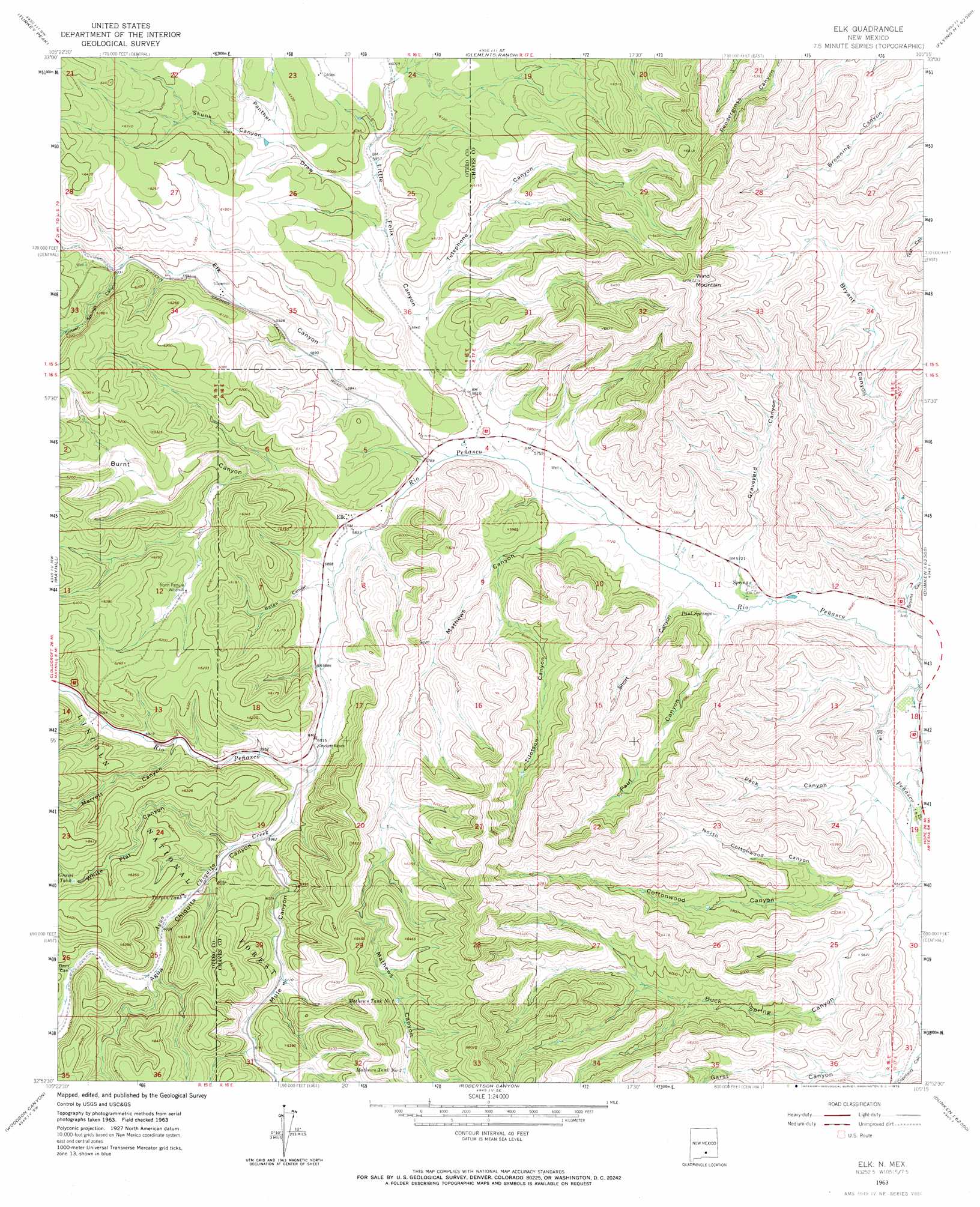
Elk Topo Map New Mexico
To zoom in, hover over the map of Elk
USGS Topo Quad 32105h3 - 1:24,000 scale
| Topo Map Name: | Elk |
| USGS Topo Quad ID: | 32105h3 |
| Print Size: | ca. 21 1/4" wide x 27" high |
| Southeast Coordinates: | 32.875° N latitude / 105.25° W longitude |
| Map Center Coordinates: | 32.9375° N latitude / 105.3125° W longitude |
| U.S. State: | NM |
| Filename: | o32105h3.jpg |
| Download Map JPG Image: | Elk topo map 1:24,000 scale |
| Map Type: | Topographic |
| Topo Series: | 7.5´ |
| Map Scale: | 1:24,000 |
| Source of Map Images: | United States Geological Survey (USGS) |
| Alternate Map Versions: |
Elk NM 1963, updated 1967 Download PDF Buy paper map Elk NM 1963, updated 1972 Download PDF Buy paper map Elk NM 2004, updated 2006 Download PDF Buy paper map Elk NM 2011 Download PDF Buy paper map Elk NM 2013 Download PDF Buy paper map Elk NM 2017 Download PDF Buy paper map |
| FStopo: | US Forest Service topo Elk is available: Download FStopo PDF Download FStopo TIF |
1:24,000 Topo Quads surrounding Elk
Whitetail |
Pajarita Mountain |
Deadman Lake |
Flying H Nw |
Flying H Ne |
Elk-Silver |
Turkey Peak |
Clements Ranch |
Loco Canyon |
Flying H |
Harvey Ranch |
Mayhill |
Elk |
Thimble Canyon |
Singer Lake |
Sacramento |
Woodson Canyon |
Robertson Canyon |
Dunken |
Meadow Hill |
Bear Spring |
Avis |
Chimney Lake |
Lewis Peak |
Lewis Peak Ne |
> Back to 32105e1 at 1:100,000 scale
> Back to 32104a1 at 1:250,000 scale
> Back to U.S. Topo Maps home
Elk topo map: Gazetteer
Elk: Populated Places
Elk elevation 1781m 5843′Elk: Post Offices
Elk Post Office (historical) elevation 1781m 5843′Elk: Reservoirs
Gravel Tank elevation 1897m 6223′Mathews Tank Number 1 elevation 1931m 6335′
Mathews Tank Number 2 elevation 1958m 6423′
Mathews Tank Number Three elevation 1927m 6322′
Pine Tank elevation 1891m 6204′
Turpin Tank elevation 1837m 6026′
Turpin Tank elevation 1915m 6282′
Elk: Springs
Paul Springs elevation 1745m 5725′Elk: Streams
Agua Chiquita Creek elevation 1805m 5921′Elk: Summits
Wind Mountain elevation 2060m 6758′Elk: Valleys
Agua Chiquita Canyon elevation 1806m 5925′Bates Canyon elevation 1791m 5875′
Bryant Canyon elevation 1695m 5561′
Burnt Canyon elevation 1779m 5836′
Dam Canyon elevation 1866m 6122′
Elk Canyon elevation 1767m 5797′
Garst Canyon elevation 1717m 5633′
Graveyard Canyon elevation 1731m 5679′
Little Felix Canyon elevation 1765m 5790′
Mathews Canyon elevation 1737m 5698′
Merrett Canyon elevation 1829m 6000′
Mule Canyon elevation 1824m 5984′
North Cottonwood Canyon elevation 1705m 5593′
Panther Draw elevation 1816m 5958′
Paul Canyon elevation 1730m 5675′
Peck Canyon elevation 1709m 5606′
Short Canyon elevation 1732m 5682′
Sixteen Springs Canyon elevation 1839m 6033′
Skunk Canyon elevation 1836m 6023′
Telephone Canyon elevation 1791m 5875′
Tilotson Canyon elevation 1780m 5839′
White Flat Canyon elevation 1826m 5990′
Elk: Wells
10356 Water Well elevation 1752m 5748′10357 Water Well elevation 1749m 5738′
10358 Water Well elevation 1776m 5826′
10359 Water Well elevation 1753m 5751′
10360 Water Well elevation 1778m 5833′
10361 Water Well elevation 1750m 5741′
10362 Water Well elevation 1740m 5708′
10636 Water Well elevation 1766m 5793′
10637 Water Well elevation 1755m 5757′
10638 Water Well elevation 1775m 5823′
10639 Water Well elevation 1845m 6053′
10640 Water Well elevation 1739m 5705′
10641 Water Well elevation 1736m 5695′
10642 Water Well elevation 1755m 5757′
10643 Water Well elevation 1729m 5672′
10644 Water Well elevation 1731m 5679′
10645 Water Well elevation 1856m 6089′
12770 Water Well elevation 1725m 5659′
Elk digital topo map on disk
Buy this Elk topo map showing relief, roads, GPS coordinates and other geographical features, as a high-resolution digital map file on DVD: