Smyrna Topo Map Texas
To zoom in, hover over the map of Smyrna
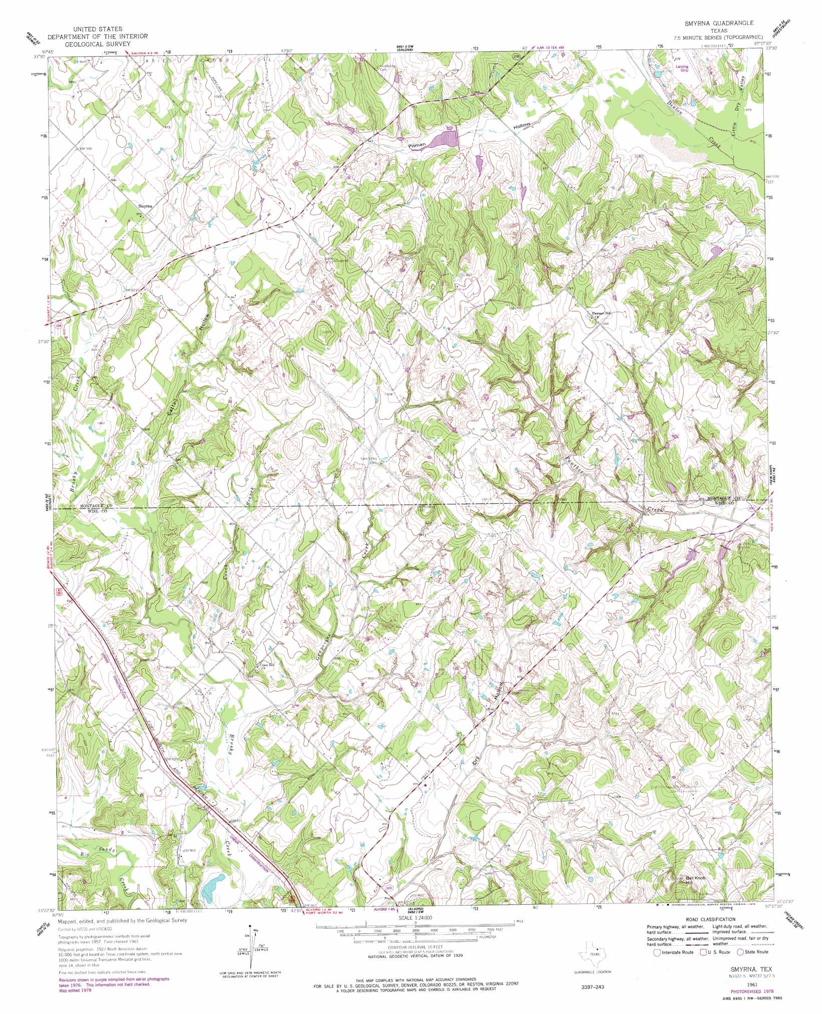
USGS Topo Quad 33097d6 - 1:24,000 scale
| Topo Map Name: | Smyrna |
| USGS Topo Quad ID: | 33097d6 |
| Print Size: | ca. 21 1/4" wide x 27" high |
| Southeast Coordinates: | 33.375° N latitude / 97.625° W longitude |
| Map Center Coordinates: | 33.4375° N latitude / 97.6875° W longitude |
| U.S. State: | TX |
| Filename: | o33097d6.jpg |
| Download Map JPG Image: | Smyrna topo map 1:24,000 scale |
| Map Type: | Topographic |
| Topo Series: | 7.5´ |
| Map Scale: | 1:24,000 |
| Source of Map Images: | United States Geological Survey (USGS) |
| Alternate Map Versions: |
Smyrna TX 1961, updated 1963 Download PDF Buy paper map Smyrna TX 1961, updated 1978 Download PDF Buy paper map Smyrna TX 2010 Download PDF Buy paper map Smyrna TX 2013 Download PDF Buy paper map Smyrna TX 2016 Download PDF Buy paper map |
| FStopo: | US Forest Service topo Smyrna is available: Download FStopo PDF Download FStopo TIF |
1:24,000 Topo Quads surrounding Smyrna
Stoneburg |
Buzzard Roost Knob |
Montague |
Saint Jo |
Muenster West |
Brushy Mound |
Bowie |
Salona |
Forestburg |
Freemound |
Selma |
Sunset |
Smyrna |
New Harp |
Greenwood |
Crafton |
Chico |
Alvord |
Pecan Creek |
Slidell |
Wizard Wells |
Bridgeport West |
Bridgeport East |
Decatur |
Bluett |
> Back to 33097a1 at 1:100,000 scale
> Back to 33096a1 at 1:250,000 scale
> Back to U.S. Topo Maps home
Smyrna topo map: Gazetteer
Smyrna: Dams
Soil Conservation Service Sediment Control Structure 11-7 elevation 277m 908′Soil Conservation Service Sediment Control Structure 9-3 elevation 278m 912′
Soil Conservation Service Site 11b Dam elevation 281m 921′
Soil Conservation Service Site 11c Dam elevation 276m 905′
Soil Conservation Service Site 11d Dam elevation 277m 908′
Soil Conservation Service Site 11e Dam elevation 277m 908′
Soil Conservation Service Site 22a Dam elevation 271m 889′
Soil Conservation Service Site 6 Dam elevation 283m 928′
Soil Conservation Service Site 6a Dam elevation 282m 925′
Soil Conservation Service Site 7a Dam elevation 279m 915′
Soil Conservation Service Site 8b Dam elevation 272m 892′
Smyrna: Forests
Lyndon B Johnson National Grassland elevation 296m 971′Smyrna: Populated Places
Smyrna elevation 294m 964′Smyrna: Reservoirs
Soil Conservation Service Sediment Control Structure 11-7 Reservoir elevation 277m 908′Soil Conservation Service Sediment Control Structure 9-3 Reservoir elevation 278m 912′
Soil Conservation Service Site 11b Reservoir elevation 281m 921′
Soil Conservation Service Site 11c Reservoir elevation 276m 905′
Soil Conservation Service Site 11d Reservoir elevation 277m 908′
Soil Conservation Service Site 11e Reservoir elevation 277m 908′
Soil Conservation Service Site 22a Reservoir elevation 271m 889′
Soil Conservation Service Site 6 Reservoir elevation 283m 928′
Soil Conservation Service Site 6a Reservoir elevation 282m 925′
Soil Conservation Service Site 7a Reservoir elevation 279m 915′
Soil Conservation Service Site 8b Reservoir elevation 272m 892′
Smyrna: Streams
Couch Branch elevation 253m 830′Couch Branch elevation 253m 830′
Grapevine Creek elevation 256m 839′
Grapevine Creek elevation 252m 826′
Smyrna: Summits
Ball Knob Hill elevation 361m 1184′Smyrna: Valleys
Cattail Hollow elevation 266m 872′Cattail Hollow elevation 265m 869′
Little Dry Valley elevation 266m 872′
Little Dry Valley elevation 267m 875′
Pitman Hollow elevation 270m 885′
Pitman Hollow elevation 270m 885′
Smyrna digital topo map on disk
Buy this Smyrna topo map showing relief, roads, GPS coordinates and other geographical features, as a high-resolution digital map file on DVD: