Luis Lopez Topo Map New Mexico
To zoom in, hover over the map of Luis Lopez
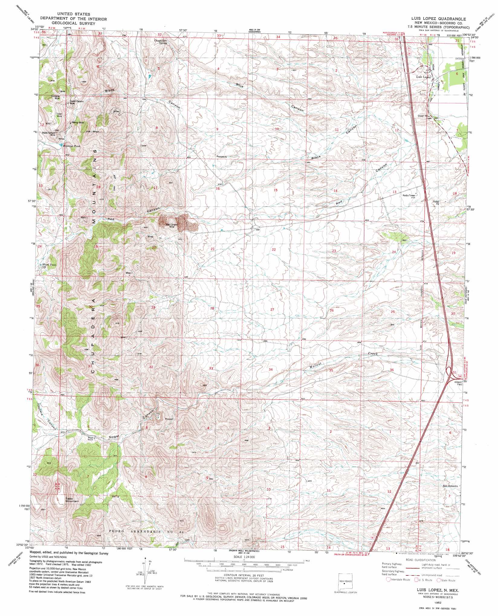
USGS Topo Quad 33106h8 - 1:24,000 scale
| Topo Map Name: | Luis Lopez |
| USGS Topo Quad ID: | 33106h8 |
| Print Size: | ca. 21 1/4" wide x 27" high |
| Southeast Coordinates: | 33.875° N latitude / 106.875° W longitude |
| Map Center Coordinates: | 33.9375° N latitude / 106.9375° W longitude |
| U.S. State: | NM |
| Filename: | o33106h8.jpg |
| Download Map JPG Image: | Luis Lopez topo map 1:24,000 scale |
| Map Type: | Topographic |
| Topo Series: | 7.5´ |
| Map Scale: | 1:24,000 |
| Source of Map Images: | United States Geological Survey (USGS) |
| Alternate Map Versions: |
Luis Lopez NM 1982, updated 1982 Download PDF Buy paper map Luis Lopez NM 2010 Download PDF Buy paper map Luis Lopez NM 2013 Download PDF Buy paper map Luis Lopez NM 2017 Download PDF Buy paper map |
1:24,000 Topo Quads surrounding Luis Lopez
Granite Mountain |
San Lorenzo Spring |
Lemitar |
Mesa Del Yeso |
Sierra De La Cruz |
Magdalena |
Water Canyon |
Socorro |
Loma De Las Canas |
Bustos Well |
South Baldy |
Molino Peak |
Luis Lopez |
San Antonio |
Canon Agua Buena |
Puertecito Gap |
Cienega Ranch |
Indian Well Wilderness |
San Antonio Se |
Cerro De La Campana |
Hickman Ranch |
Fort Craig |
San Marcial |
Little San Pasqual Mountain |
Granjean Well |
> Back to 33106e1 at 1:100,000 scale
> Back to 33106a1 at 1:250,000 scale
> Back to U.S. Topo Maps home
Luis Lopez topo map: Gazetteer
Luis Lopez: Crossings
179 United States 380 San Antonio Interchange elevation 1421m 4662′Luis Lopez: Mines
Big Basin elevation 1768m 5800′Big Basin Group-Luis Lopez D Mine elevation 1713m 5620′
Black Cat Claims-Luis Lopez elevation 1697m 5567′
Black Crow and San Juan Claims elevation 1749m 5738′
Blue Gold-Luis Lopez District elevation 1674m 5492′
Esperanza Group-Luis Lopez elevation 1711m 5613′
Frank Number 2-Luis Lopez District elevation 1636m 5367′
Gloryyana Deposit-Luis Lopez District elevation 1733m 5685′
Grand Canyon - Luis Lopez Distict Mine elevation 1733m 5685′
Griffith Claims-Luis Lopez elevation 1677m 5501′
Gussie Mine elevation 1733m 5685′
Iron Horse elevation 1533m 5029′
Lucky Strike and Grand Canyon Mine elevation 1774m 5820′
Lucky Strike Number 1-Luis Lopez District elevation 1761m 5777′
M and M elevation 1770m 5807′
M and M Group elevation 1765m 5790′
Pretty Girl Group-Luis Lopez elevation 1794m 5885′
Red Hill Claims-Luis Lopez District elevation 1680m 5511′
Red Hill Ext.Claim-Luis Lopez elevation 1640m 5380′
Luis Lopez: Populated Places
Luis Lopez elevation 1399m 4589′Luis Lopez: Ranges
Chupadera Mountains elevation 1917m 6289′Luis Lopez: Reservoirs
Miera Tank elevation 1702m 5583′Montoya Tank elevation 1722m 5649′
Luis Lopez: Springs
Chupadera Spring elevation 1621m 5318′Luis Lopez: Valleys
Madera Canyon elevation 1681m 5515′Red Canyon elevation 1400m 4593′
Rincon Madera elevation 1696m 5564′
Luis Lopez: Wells
10044 Water Well elevation 1518m 4980′Luis Lopez digital topo map on disk
Buy this Luis Lopez topo map showing relief, roads, GPS coordinates and other geographical features, as a high-resolution digital map file on DVD: