Cottonwood Basin Topo Map California
To zoom in, hover over the map of Cottonwood Basin
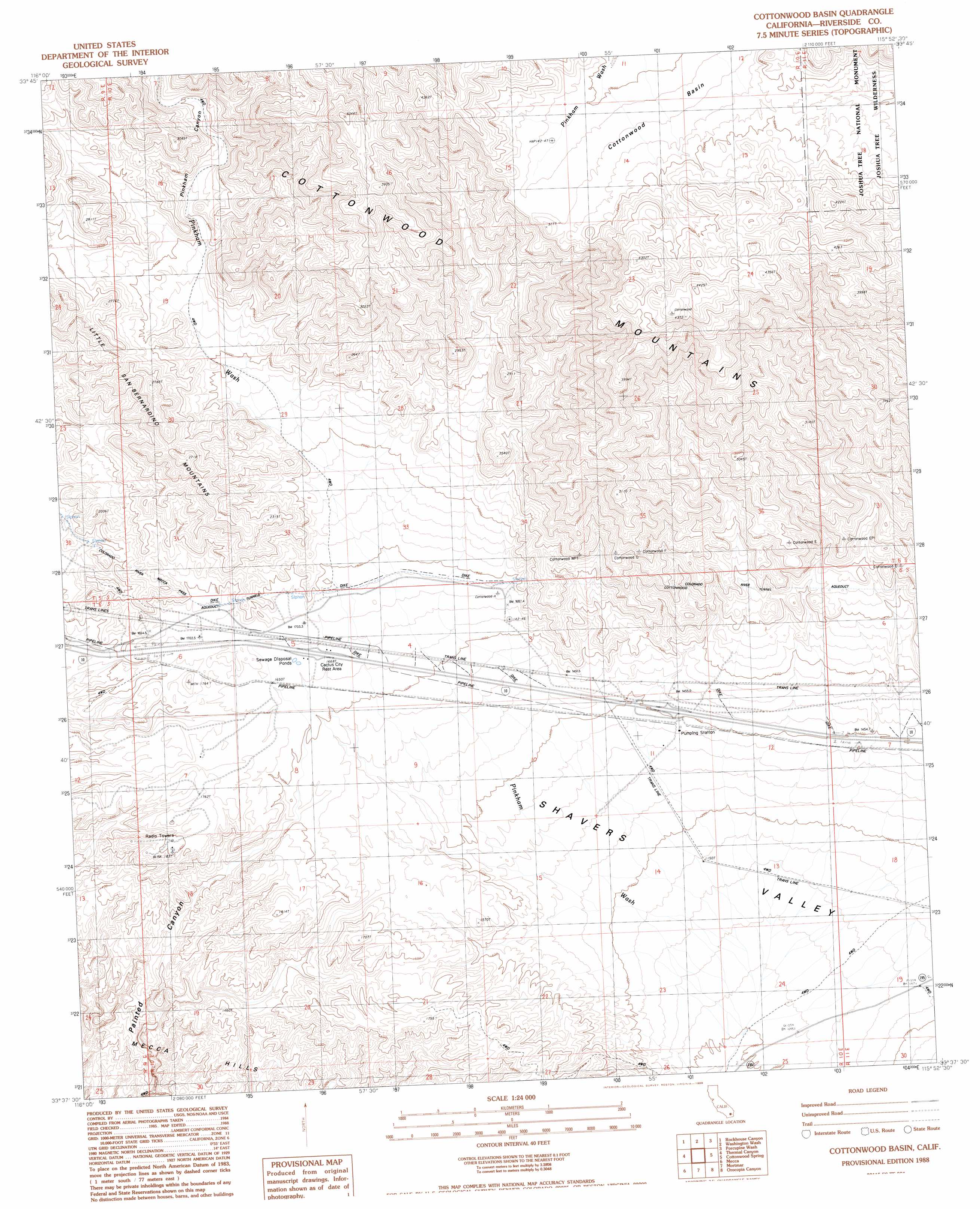
USGS Topo Quad 33115f8 - 1:24,000 scale
| Topo Map Name: | Cottonwood Basin |
| USGS Topo Quad ID: | 33115f8 |
| Print Size: | ca. 21 1/4" wide x 27" high |
| Southeast Coordinates: | 33.625° N latitude / 115.875° W longitude |
| Map Center Coordinates: | 33.6875° N latitude / 115.9375° W longitude |
| U.S. State: | CA |
| Filename: | o33115f8.jpg |
| Download Map JPG Image: | Cottonwood Basin topo map 1:24,000 scale |
| Map Type: | Topographic |
| Topo Series: | 7.5´ |
| Map Scale: | 1:24,000 |
| Source of Map Images: | United States Geological Survey (USGS) |
| Alternate Map Versions: |
Cottonwood Basin CA 1988, updated 1988 Download PDF Buy paper map Cottonwood Basin CA 1988, updated 1995 Download PDF Buy paper map Cottonwood Basin CA 2012 Download PDF Buy paper map Cottonwood Basin CA 2015 Download PDF Buy paper map |
1:24,000 Topo Quads surrounding Cottonwood Basin
Keys View |
Malapai Hill |
Fried Liver Wash |
Pinto Mountain |
San Bernardino Wash |
West Berdoo Canyon |
Rockhouse Canyon |
Washington Wash |
Porcupine Wash |
Conejo Well |
Indio |
Thermal Canyon |
Cottonwood Basin |
Cottonwood Spring |
Hayfield |
Valerie |
Mecca |
Mortmar |
Orocopia Canyon |
Red Canyon |
Rabbit Peak |
Oasis |
Salton |
Durmid |
Frink Nw |
> Back to 33115e1 at 1:100,000 scale
> Back to 33114a1 at 1:250,000 scale
> Back to U.S. Topo Maps home
Cottonwood Basin topo map: Gazetteer
Cottonwood Basin: Basins
Cottonwood Basin elevation 1108m 3635′Cottonwood Basin: Canals
Colorado River Aqueduct elevation 542m 1778′Cottonwood Basin: Parks
Cactus City Rest Area elevation 508m 1666′Cottonwood Basin: Populated Places
Cactus City elevation 508m 1666′Cottonwood Basin: Ranges
Cottonwood Mountains elevation 1045m 3428′Cottonwood Basin: Streams
Pinkham Wash elevation 310m 1017′Cottonwood Basin: Tunnels
Cottonwood Tunnel elevation 621m 2037′Mecca Pass Tunnels elevation 537m 1761′
Cottonwood Basin: Valleys
Pinkham Canyon elevation 619m 2030′Cottonwood Basin digital topo map on disk
Buy this Cottonwood Basin topo map showing relief, roads, GPS coordinates and other geographical features, as a high-resolution digital map file on DVD: