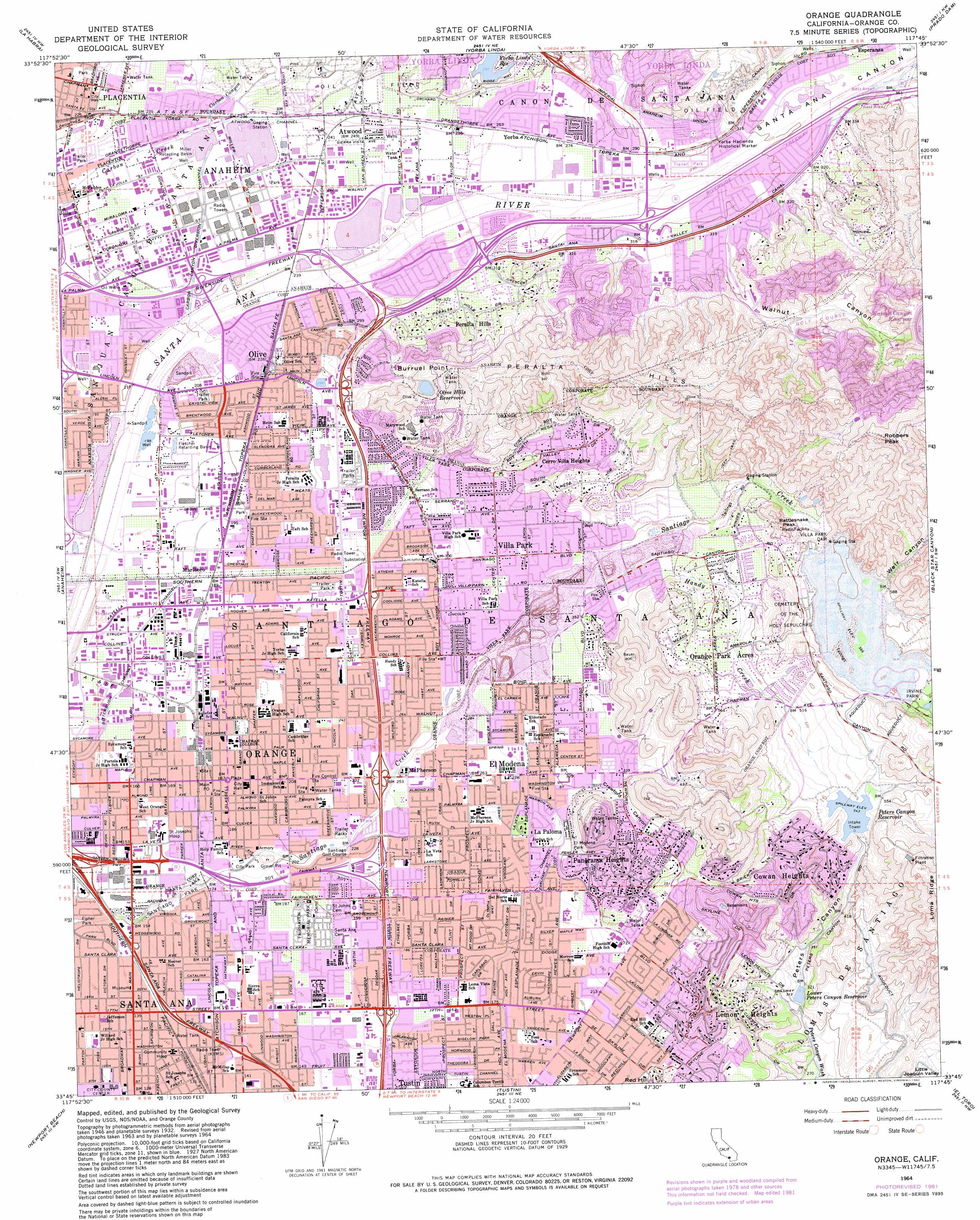
Orange Topo Map California
To zoom in, hover over the map of Orange
USGS Topo Quad 33117g7 - 1:24,000 scale
| Topo Map Name: | Orange |
| USGS Topo Quad ID: | 33117g7 |
| Print Size: | ca. 21 1/4" wide x 27" high |
| Southeast Coordinates: | 33.75° N latitude / 117.75° W longitude |
| Map Center Coordinates: | 33.8125° N latitude / 117.8125° W longitude |
| U.S. State: | CA |
| Filename: | o33117g7.jpg |
| Download Map JPG Image: | Orange topo map 1:24,000 scale |
| Map Type: | Topographic |
| Topo Series: | 7.5´ |
| Map Scale: | 1:24,000 |
| Source of Map Images: | United States Geological Survey (USGS) |
| Alternate Map Versions: |
Orange CA 1949, updated 1956 Download PDF Buy paper map Orange CA 1950 Download PDF Buy paper map Orange CA 1964, updated 1966 Download PDF Buy paper map Orange CA 1964, updated 1974 Download PDF Buy paper map Orange CA 1964, updated 1982 Download PDF Buy paper map Orange CA 1974, updated 1977 Download PDF Buy paper map Orange CA 2012 Download PDF Buy paper map Orange CA 2015 Download PDF Buy paper map |
1:24,000 Topo Quads surrounding Orange
El Monte |
Baldwin Park |
San Dimas |
Ontario |
Guasti |
Whittier |
La Habra |
Yorba Linda |
Prado Dam |
Corona North |
Los Alamitos |
Anaheim |
Orange |
Black Star Canyon |
Corona South |
Seal Beach |
Newport Beach |
Tustin |
El Toro |
Santiago Peak |
Laguna Beach |
San Juan Capistrano |
Canada Gobernadora * |
> Back to 33117e1 at 1:100,000 scale
> Back to 33116a1 at 1:250,000 scale
> Back to U.S. Topo Maps home
Orange topo map: Gazetteer
Orange: Airports
Choc Heliport elevation 49m 160′First Interstate Bank Building Heliport elevation 40m 131′
Orange County Steel Salvage Heliport elevation 67m 219′
RI An Anaheim Helistop B/250 elevation 70m 229′
RI An Anaheim Helistop G/l B/201 elevation 69m 226′
SCE Serrano Substation Heliport elevation 213m 698′
Orange: Basins
Miller Retarding Basin elevation 68m 223′Santiago Creek Recharge Basin elevation 98m 321′
Orange: Beaches
Santa Ana Fire Station 10 elevation 55m 180′Orange: Bridges
Jefferson Street Bridge elevation 71m 232′Yorba Bridge elevation 87m 285′
Orange: Canals
Anaheim Union Canal elevation 116m 380′Bitterbush Channel elevation 44m 144′
Collins Channel elevation 50m 164′
East Richfield Channel elevation 89m 291′
Orange: Channels
Atwood Channel elevation 73m 239′Carbon Canyon Diversion Channel elevation 68m 223′
Orange: Crossings
Exit 104B elevation 50m 164′Exit 105A elevation 50m 164′
Exit 105B elevation 43m 141′
Exit 12 elevation 50m 164′
Exit 13 elevation 69m 226′
Exit 14 elevation 80m 262′
Exit 14D elevation 43m 141′
Exit 15 elevation 50m 164′
Exit 15 elevation 80m 262′
Exit 16 elevation 57m 187′
Exit 17 elevation 92m 301′
Exit 17A elevation 65m 213′
Exit 17B elevation 67m 219′
Exit 17C elevation 68m 223′
Exit 31 elevation 62m 203′
Exit 32 elevation 68m 223′
Exit 33 elevation 70m 229′
Exit 34 elevation 91m 298′
Exit 35 elevation 91m 298′
Exit 5A elevation 62m 203′
Orange: Dams
Olive Hills Reservoir 1037-002 Dam elevation 167m 547′Peters Canyon 793-002 Dam elevation 166m 544′
Villa Park Dam elevation 177m 580′
Walnut Canyon 1037 Dam elevation 258m 846′
Yorba 1012-003 Dam elevation 91m 298′
Orange: Parks
Avalon Park elevation 56m 183′Cabrillo Park elevation 46m 150′
Camino Real Park elevation 48m 157′
Chapman Plaza elevation 59m 193′
Chapman Stadium elevation 61m 200′
Eisenhower Park elevation 97m 318′
El Modena Park elevation 91m 298′
Esplanade Park elevation 64m 209′
Eucalyptus Park elevation 91m 298′
French Park elevation 41m 134′
Gershon Place Mini Park elevation 53m 173′
Handy Park elevation 82m 269′
Hart Park elevation 55m 180′
Imperial Park elevation 140m 459′
Killefer Park elevation 59m 193′
Kraemer Memorial Park elevation 74m 242′
Liberty Plaza elevation 59m 193′
Logan Park elevation 44m 144′
Mabury Park elevation 47m 154′
McFadden Park elevation 63m 206′
Oak Canyon Nature Center elevation 207m 679′
Oak Park elevation 174m 570′
Olive Hills Park elevation 147m 482′
Olive Park elevation 66m 216′
Parque de Los Ninos elevation 77m 252′
Pelanconi Park elevation 125m 410′
Peralta Canyon Park elevation 89m 291′
Peters Canyon Regional Park elevation 115m 377′
Plaza Historic District elevation 58m 190′
Plaza Square Park elevation 58m 190′
Richard Samp Park elevation 81m 265′
Rio Vista Park elevation 64m 209′
Riverdale Park elevation 81m 265′
Santa Fe Depot Park elevation 56m 183′
Santiago Oaks Regional Park elevation 209m 685′
Santiago Park elevation 46m 150′
Shaffer Park elevation 61m 200′
Sycamore Park elevation 47m 154′
Williams Mall elevation 59m 193′
Woodgate Park elevation 112m 367′
Yorba Hacienda Historical Marker elevation 100m 328′
Yorba Park elevation 76m 249′
Yorba Regional Park elevation 94m 308′
Orange: Populated Places
Anaheim Hills elevation 127m 416′Atwood elevation 75m 246′
Carriage Mobile Home Estates elevation 61m 200′
Cerro Villa Heights elevation 152m 498′
Cowan Heights elevation 221m 725′
Creekside Mobile Home Estates elevation 71m 232′
Del Cerro Mobile Home Estates elevation 88m 288′
El Modena elevation 89m 291′
Friendly Village of Anaheim elevation 90m 295′
Goforth Mobile Home Village elevation 79m 259′
Hacienda Mobile Home Park elevation 65m 213′
Hewes Park elevation 74m 242′
La Paloma elevation 86m 282′
Lemon Heights elevation 176m 577′
Marlboro elevation 55m 180′
McPherson elevation 76m 249′
North Tustin elevation 78m 255′
Olive elevation 68m 223′
Orange elevation 58m 190′
Orange Mobile Home Park elevation 81m 265′
Orange Park Acres elevation 146m 479′
Orange Village Mobile Home Park elevation 73m 239′
Panorama Heights elevation 115m 377′
Peralta Hills elevation 105m 344′
Placentia elevation 83m 272′
Richfields elevation 77m 252′
Rio Vista Mobile Home Estates elevation 65m 213′
Villa Park elevation 104m 341′
Wanda (historical) elevation 92m 301′
Yorba elevation 82m 269′
Orange: Post Offices
Anaheim Hills Station Anaheim Post Office elevation 99m 324′El Modena Station Orange Post Office elevation 83m 272′
Olive Station Orange Post Office elevation 66m 216′
Orange Post Office elevation 79m 259′
Plaza Station Orange Post Office elevation 56m 183′
Santa Ana Post Office elevation 53m 173′
Spurgeon Station Santa Ana Post Office elevation 38m 124′
Orange: Ranges
Peralta Hills elevation 351m 1151′Orange: Reservoirs
Anaheim Lake elevation 71m 232′Fletcher Retarding Basin elevation 58m 190′
Lower Peters Canyon Reservoir elevation 97m 318′
Olive Hills Reservoir elevation 167m 547′
Peters Canyon Reservoir elevation 166m 544′
Walnut Canyon Reservoir elevation 258m 846′
Yorba Linda Reservoir elevation 91m 298′
Orange: Ridges
Burruel Point elevation 195m 639′Orange: Streams
Carbon Canyon Creek elevation 70m 229′Handy Creek elevation 105m 344′
Orange: Summits
Rattlesnake Peak elevation 225m 738′Robbers Peak elevation 329m 1079′
Orange: Valleys
Crawford Canyon elevation 90m 295′Peters Canyon elevation 99m 324′
Santa Ana Canyon elevation 80m 262′
Walnut Canyon elevation 109m 357′
Weir Canyon elevation 175m 574′
Orange digital topo map on disk
Buy this Orange topo map showing relief, roads, GPS coordinates and other geographical features, as a high-resolution digital map file on DVD: