Wapanucka South Topo Map Oklahoma
To zoom in, hover over the map of Wapanucka South
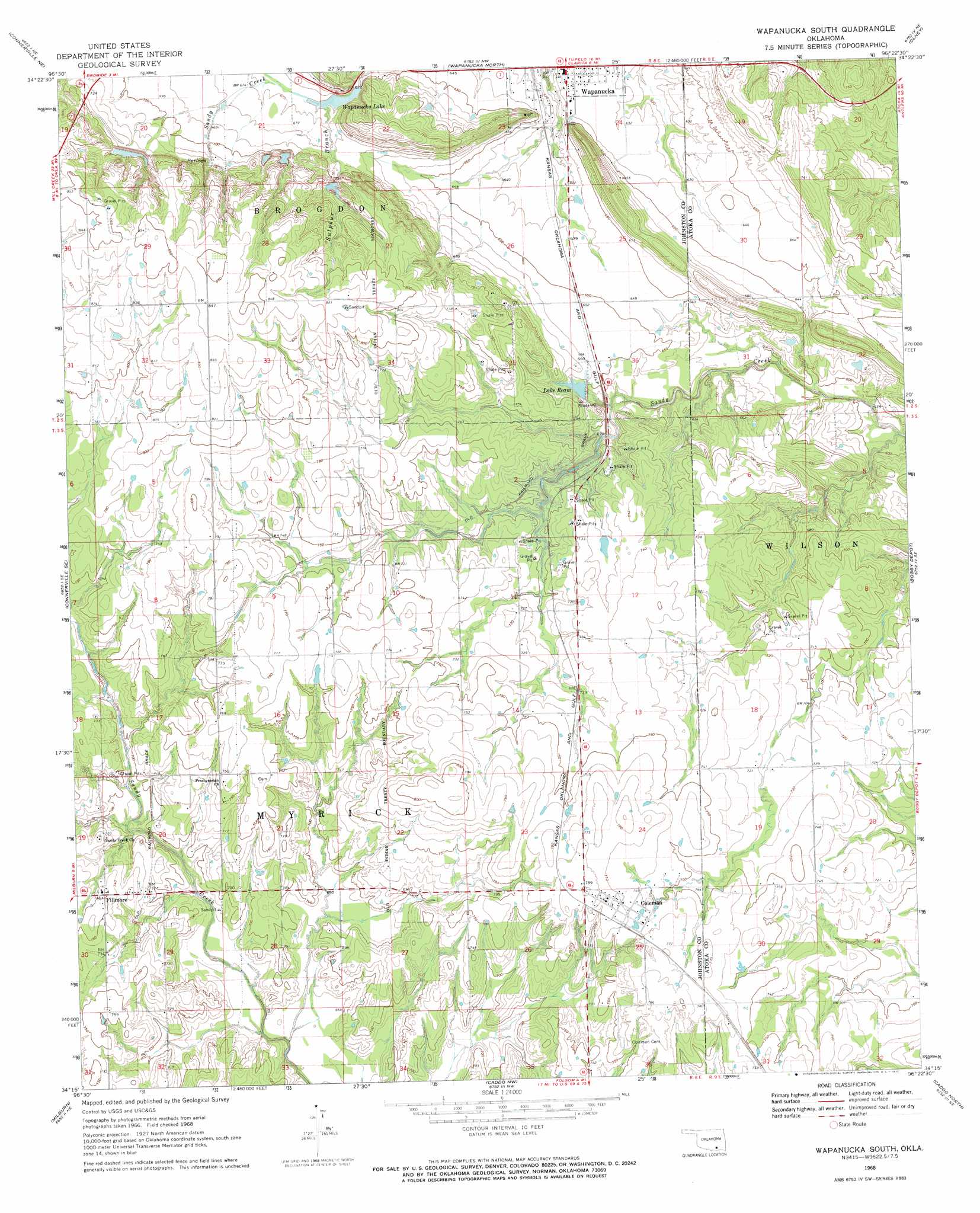
USGS Topo Quad 34096c4 - 1:24,000 scale
| Topo Map Name: | Wapanucka South |
| USGS Topo Quad ID: | 34096c4 |
| Print Size: | ca. 21 1/4" wide x 27" high |
| Southeast Coordinates: | 34.25° N latitude / 96.375° W longitude |
| Map Center Coordinates: | 34.3125° N latitude / 96.4375° W longitude |
| U.S. State: | OK |
| Filename: | o34096c4.jpg |
| Download Map JPG Image: | Wapanucka South topo map 1:24,000 scale |
| Map Type: | Topographic |
| Topo Series: | 7.5´ |
| Map Scale: | 1:24,000 |
| Source of Map Images: | United States Geological Survey (USGS) |
| Alternate Map Versions: |
Wapanucka South OK 1968, updated 1971 Download PDF Buy paper map Wapanucka South OK 2009 Download PDF Buy paper map Wapanucka South OK 2012 Download PDF Buy paper map Wapanucka South OK 2016 Download PDF Buy paper map |
1:24,000 Topo Quads surrounding Wapanucka South
Fittstown |
Harden City |
Tupelo |
Centrahoma |
Coalgate |
Connerville |
Connerville Ne |
Wapanucka North |
Olney |
Lehigh |
Reagan |
Connerville Se |
Wapanucka South |
Boggy Depot |
Tushka |
Kingston North |
Milburn |
Caddo Nw |
Caddo North |
Caney |
Kingston North |
Little City |
Durant North |
Caddo South |
Bokchito |
> Back to 34096a1 at 1:100,000 scale
> Back to 34096a1 at 1:250,000 scale
> Back to U.S. Topo Maps home
Wapanucka South topo map: Gazetteer
Wapanucka South: Dams
Delaware Creek Site 3 Dam elevation 188m 616′Delaware Creek Site 5 Dam elevation 226m 741′
Delaware Creek Site 6 Dam elevation 214m 702′
Delaware Creek Site 7 Dam elevation 223m 731′
Lake Ream Dam elevation 219m 718′
Lake Wapanucka Dam elevation 229m 751′
Lower Clear Boggy Creek Site 14 Dam elevation 181m 593′
Lower Clear Boggy Creek Site 17 Dam elevation 213m 698′
Wapanucka South: Populated Places
Coleman elevation 235m 770′Fillmore elevation 228m 748′
Wapanucka elevation 193m 633′
Wapanucka South: Reservoirs
Delaware Creek Site 3 Reservoir elevation 188m 616′Delaware Creek Site 5 Reservoir elevation 226m 741′
Delaware Creek Site 6 Reservoir elevation 214m 702′
Delaware Creek Site 7 Reservoir elevation 223m 731′
Lake Ream elevation 219m 718′
Lake Ream elevation 194m 636′
Lake Wapanucka elevation 229m 751′
Lower Clear Boggy Creek Site 14 Reservoir elevation 181m 593′
Lower Clear Boggy Creek Site 17 Reservoir elevation 213m 698′
Wapanucka Lake elevation 201m 659′
Wapanucka South: Streams
Sulphur Branch elevation 202m 662′Wapanucka South digital topo map on disk
Buy this Wapanucka South topo map showing relief, roads, GPS coordinates and other geographical features, as a high-resolution digital map file on DVD: