Portsmouth Topo Map North Carolina
To zoom in, hover over the map of Portsmouth
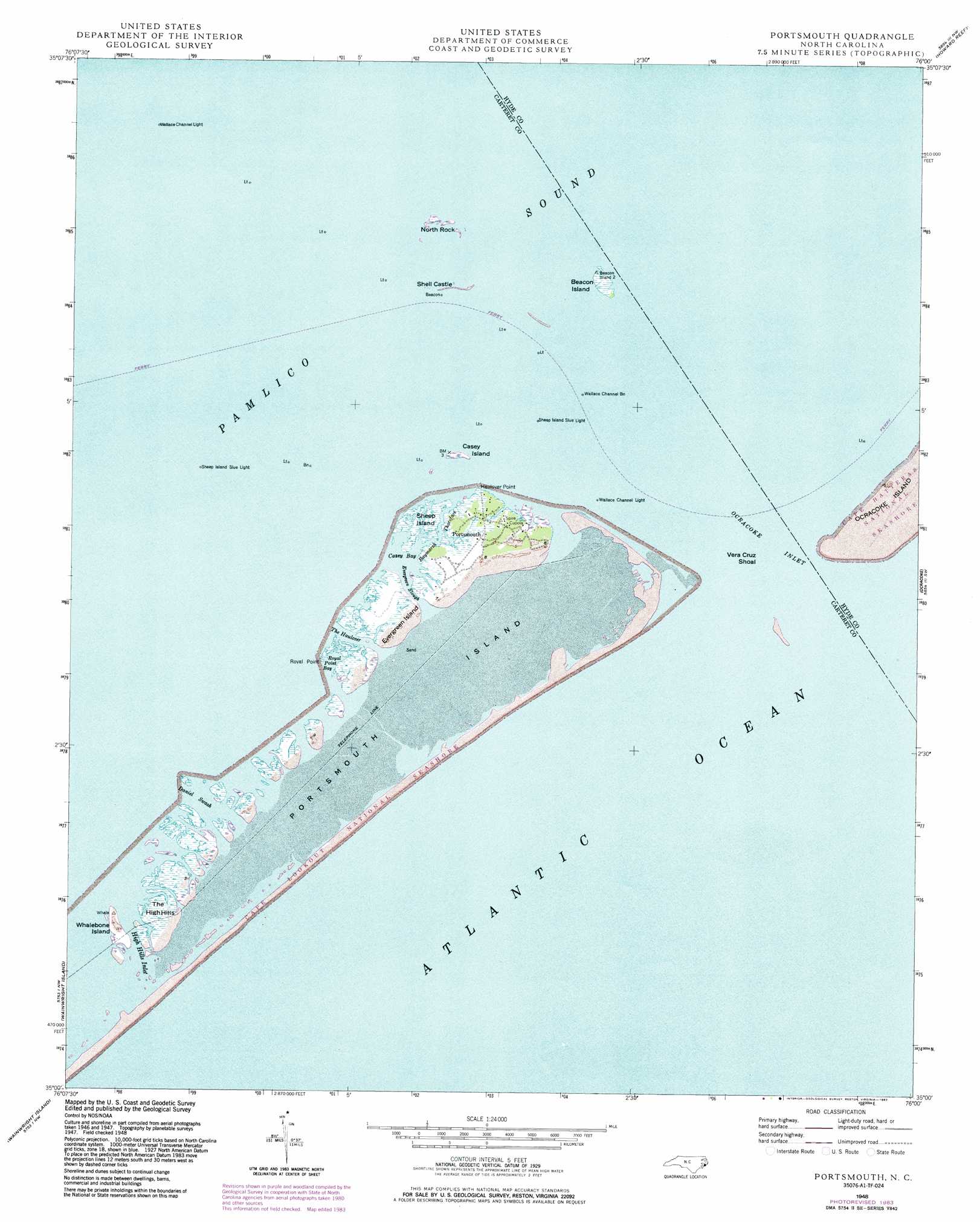
USGS Topo Quad 35076a1 - 1:24,000 scale
| Topo Map Name: | Portsmouth |
| USGS Topo Quad ID: | 35076a1 |
| Print Size: | ca. 21 1/4" wide x 27" high |
| Southeast Coordinates: | 35° N latitude / 76° W longitude |
| Map Center Coordinates: | 35.0625° N latitude / 76.0625° W longitude |
| U.S. State: | NC |
| Filename: | o35076a1.jpg |
| Download Map JPG Image: | Portsmouth topo map 1:24,000 scale |
| Map Type: | Topographic |
| Topo Series: | 7.5´ |
| Map Scale: | 1:24,000 |
| Source of Map Images: | United States Geological Survey (USGS) |
| Alternate Map Versions: |
Portsmouth NC 1948, updated 1976 Download PDF Buy paper map Portsmouth NC 1948, updated 1983 Download PDF Buy paper map Portsmouth NC 1950 Download PDF Buy paper map Portsmouth NC 1950, updated 1972 Download PDF Buy paper map Portsmouth NC 2011 Download PDF Buy paper map Portsmouth NC 2013 Download PDF Buy paper map Portsmouth NC 2016 Download PDF Buy paper map |
1:24,000 Topo Quads surrounding Portsmouth
Great Island |
Bluff Point |
Middletown |
||
Howard Reef |
Green Island |
|||
North Bay |
Portsmouth |
Ocracoke |
||
Atlantic |
Atlantic East |
|||
Styron Bay |
> Back to 35076a1 at 1:100,000 scale
> Back to 35076a1 at 1:250,000 scale
> Back to U.S. Topo Maps home
Portsmouth topo map: Gazetteer
Portsmouth: Bars
Amity Shoal (historical) elevation 0m 0′Flounder Rock elevation 0m 0′
Mount Vernon Rock elevation 0m 0′
Oyster Rocks elevation 0m 0′
Vera Cruz Shoal elevation 0m 0′
Portsmouth: Bays
Blair Channel elevation 0m 0′Casey Bay elevation 1m 3′
Daniel Swash elevation 0m 0′
Royal Point Bay elevation 0m 0′
Portsmouth: Capes
Haulover Point elevation 0m 0′Royal Point elevation 0m 0′
Portsmouth: Channels
High Hills Inlet elevation 0m 0′Horse Island Channel elevation 0m 0′
Ocracoke Inlet elevation 0m 0′
Wallace Channel elevation 0m 0′
Portsmouth: Guts
Baymarsh Thorofare elevation 0m 0′Evergreen Slough elevation 0m 0′
The Haulover elevation 0m 0′
Warren Gilgos Creek elevation 0m 0′
Whalebone Inlet elevation 0m 0′
Portsmouth: Islands
Beacon Island elevation 0m 0′Beacon Island Roads elevation 0m 0′
Casey Island elevation 0m 0′
Evergreen Island elevation 0m 0′
North Rock elevation 0m 0′
Portsmouth Island elevation 0m 0′
Sheep Island elevation 0m 0′
Shell Castle elevation 0m 0′
The High Hills elevation 0m 0′
Whalebone Island elevation 1m 3′
Portsmouth: Pillars
Ayers Rock elevation 0m 0′Portsmouth: Populated Places
Portsmouth elevation 0m 0′Portsmouth Village elevation 0m 0′
Portsmouth: Swamps
Bay Marsh (historical) elevation 0m 0′Portsmouth digital topo map on disk
Buy this Portsmouth topo map showing relief, roads, GPS coordinates and other geographical features, as a high-resolution digital map file on DVD:
Atlantic Coast (NY, NJ, PA, DE, MD, VA, NC)
Buy digital topo maps: Atlantic Coast (NY, NJ, PA, DE, MD, VA, NC)
 map DVD")