Yeager Topo Map Oklahoma
To zoom in, hover over the map of Yeager
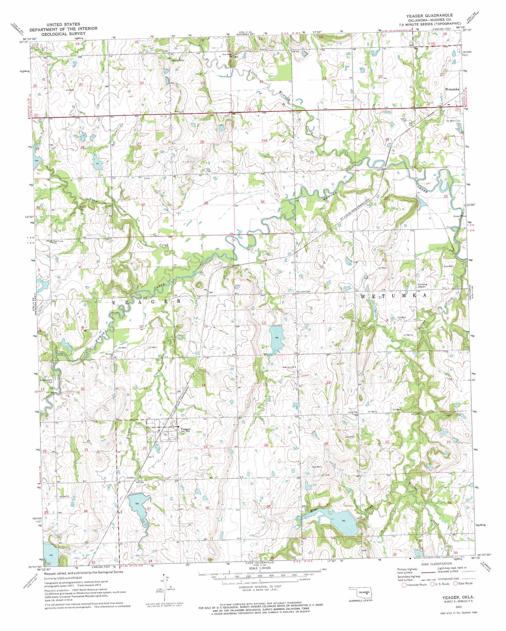
USGS Topo Quad 35096b3 - 1:24,000 scale
| Topo Map Name: | Yeager |
| USGS Topo Quad ID: | 35096b3 |
| Print Size: | ca. 21 1/4" wide x 27" high |
| Southeast Coordinates: | 35.125° N latitude / 96.25° W longitude |
| Map Center Coordinates: | 35.1875° N latitude / 96.3125° W longitude |
| U.S. State: | OK |
| Filename: | o35096b3.jpg |
| Download Map JPG Image: | Yeager topo map 1:24,000 scale |
| Map Type: | Topographic |
| Topo Series: | 7.5´ |
| Map Scale: | 1:24,000 |
| Source of Map Images: | United States Geological Survey (USGS) |
| Alternate Map Versions: |
Yeager OK 1972, updated 1974 Download PDF Buy paper map Yeager OK 2009 Download PDF Buy paper map Yeager OK 2012 Download PDF Buy paper map Yeager OK 2016 Download PDF Buy paper map |
1:24,000 Topo Quads surrounding Yeager
Prague Ne |
Boley |
Okemah |
Clearview |
Pharoah |
Prague Se |
Cromwell |
Okemah Se |
Weleetka |
Dustin |
Wewoka West |
Wewoka East |
Yeager |
Wetumka |
Carson |
Tate Mountain |
Holdenville |
Lake Holdenville |
Lamar |
Wetumka Se |
Sasakwa |
Allen |
Calvin West |
Calvin East |
Stuart |
> Back to 35096a1 at 1:100,000 scale
> Back to 35096a1 at 1:250,000 scale
> Back to U.S. Topo Maps home
Yeager topo map: Gazetteer
Yeager: Dams
Big Wewoka Creek Site 39 Dam elevation 233m 764′Big Wewoka Creek Site 40 Dam elevation 234m 767′
Big Wewoka Creek Site 41 Dam elevation 245m 803′
Big Wewoka Creek Site 42 Dam elevation 228m 748′
Little Wewoka Creek Site 12 Dam elevation 231m 757′
Maynard Richmond Dam elevation 248m 813′
Oknoname 037040 Dam elevation 224m 734′
Oknoname 037082 Dam elevation 253m 830′
Oknoname 063009 Dam elevation 247m 810′
Oknoname 063010 Dam elevation 228m 748′
Oknoname 063015 Dam elevation 238m 780′
Oknoname 063017 Dam elevation 233m 764′
Oknoname 063031 Dam elevation 242m 793′
Yeager: Populated Places
Yeager elevation 239m 784′Yeager: Reservoirs
Big Wewoka Creek Site 39 Reservoir elevation 233m 764′Big Wewoka Creek Site 40 Reservoir elevation 234m 767′
Big Wewoka Creek Site 41 Reservoir elevation 245m 803′
Big Wewoka Creek Site 42 Reservoir elevation 228m 748′
Little Wewoka Creek Site 12 Reservoir elevation 231m 757′
Maynard Richmond Reservoir elevation 248m 813′
Oknoname 037040 Reservoir elevation 224m 734′
Oknoname 037082 Reservoir elevation 253m 830′
Oknoname 063009 Reservoir elevation 247m 810′
Oknoname 063010 Reservoir elevation 228m 748′
Oknoname 063015 Reservoir elevation 238m 780′
Oknoname 063017 Reservoir elevation 233m 764′
Oknoname 063031 Reservoir elevation 242m 793′
Yeager: Streams
Elm Creek elevation 222m 728′Graves Creek elevation 213m 698′
Little Wewoka Creek elevation 218m 715′
Long George Creek elevation 223m 731′
Yeager Creek elevation 223m 731′
Yeager digital topo map on disk
Buy this Yeager topo map showing relief, roads, GPS coordinates and other geographical features, as a high-resolution digital map file on DVD: