Retrop Topo Map Oklahoma
To zoom in, hover over the map of Retrop
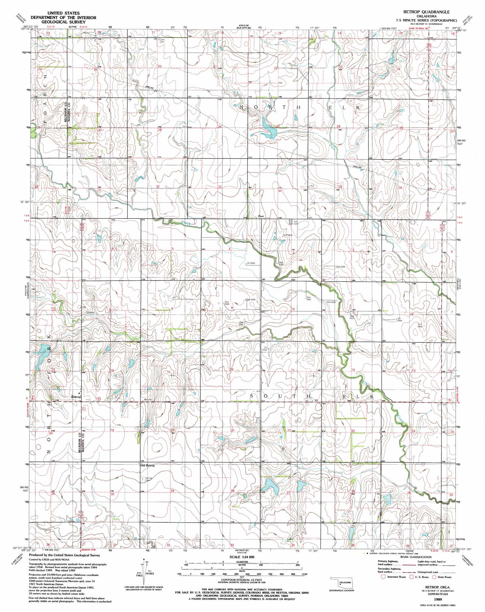
USGS Topo Quad 35099b3 - 1:24,000 scale
| Topo Map Name: | Retrop |
| USGS Topo Quad ID: | 35099b3 |
| Print Size: | ca. 21 1/4" wide x 27" high |
| Southeast Coordinates: | 35.125° N latitude / 99.25° W longitude |
| Map Center Coordinates: | 35.1875° N latitude / 99.3125° W longitude |
| U.S. State: | OK |
| Filename: | o35099b3.jpg |
| Download Map JPG Image: | Retrop topo map 1:24,000 scale |
| Map Type: | Topographic |
| Topo Series: | 7.5´ |
| Map Scale: | 1:24,000 |
| Source of Map Images: | United States Geological Survey (USGS) |
| Alternate Map Versions: |
Retrop OK 1989, updated 1989 Download PDF Buy paper map Retrop OK 2010 Download PDF Buy paper map Retrop OK 2012 Download PDF Buy paper map Retrop OK 2016 Download PDF Buy paper map |
1:24,000 Topo Quads surrounding Retrop
Baker Lake |
Elk City |
Canute |
Foss |
Dill City Ne |
Doxey |
Hocker |
Elk City Se |
Dill City |
Dill City Se |
Carter West |
Carter East |
Retrop |
Sentinel |
Rocky |
Willow |
Lake Creek |
Retrop Se |
Cambridge |
Hobart |
Mangum North |
Granite |
Lake Altus |
Lone Wolf |
Babbs |
> Back to 35099a1 at 1:100,000 scale
> Back to 35098a1 at 1:250,000 scale
> Back to U.S. Topo Maps home
Retrop topo map: Gazetteer
Retrop: Dams
Oknoname 149016 Dam elevation 512m 1679′Upper Elk Creek Site 13 Dam elevation 513m 1683′
Upper Elk Creek Site 32 Dam elevation 520m 1706′
Upper Elk Creek Site 33 Dam elevation 519m 1702′
Upper Elk Creek Site 34 Dam elevation 516m 1692′
Upper Elk Creek Site 37 Dam elevation 502m 1646′
Upper Elk Creek Site 38 Dam elevation 504m 1653′
Upper Elk Creek Site 39 Dam elevation 502m 1646′
Upper Elk Creek Site 40 Dam elevation 510m 1673′
Retrop: Oilfields
West Sentinel Oil Field elevation 521m 1709′Retrop: Populated Places
Old Retrop elevation 538m 1765′Port elevation 517m 1696′
Retrop elevation 545m 1788′
Retrop: Reservoirs
Oknoname 149016 Reservoir elevation 512m 1679′Upper Elk Creek Site 13 Reservoir elevation 513m 1683′
Upper Elk Creek Site 32 Reservoir elevation 520m 1706′
Upper Elk Creek Site 33 Reservoir elevation 519m 1702′
Upper Elk Creek Site 34 Reservoir elevation 516m 1692′
Upper Elk Creek Site 37 Reservoir elevation 502m 1646′
Upper Elk Creek Site 38 Reservoir elevation 504m 1653′
Upper Elk Creek Site 39 Reservoir elevation 502m 1646′
Upper Elk Creek Site 40 Reservoir elevation 510m 1673′
Retrop digital topo map on disk
Buy this Retrop topo map showing relief, roads, GPS coordinates and other geographical features, as a high-resolution digital map file on DVD: