Loma Machete Topo Map New Mexico
To zoom in, hover over the map of Loma Machete
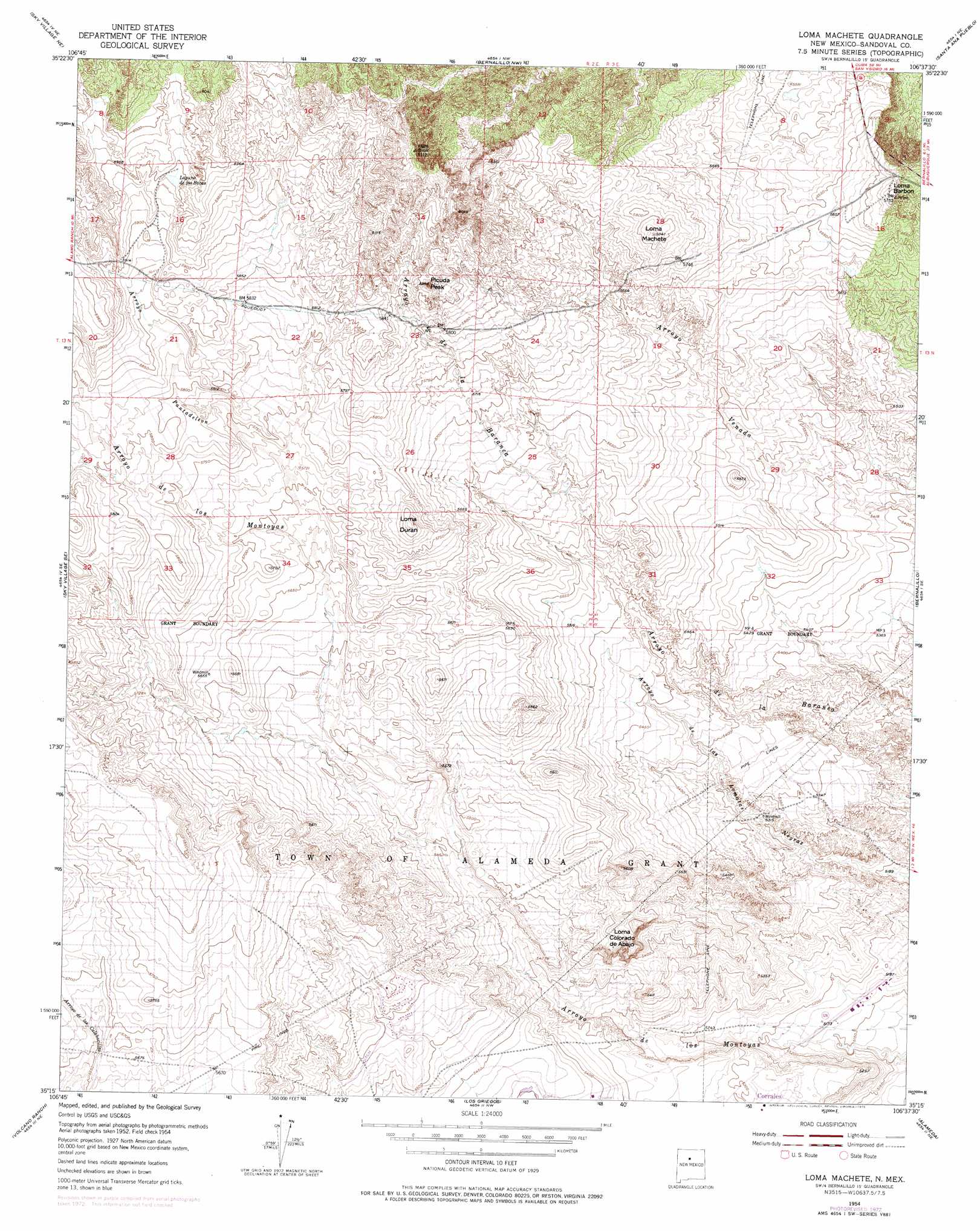
USGS Topo Quad 35106c6 - 1:24,000 scale
| Topo Map Name: | Loma Machete |
| USGS Topo Quad ID: | 35106c6 |
| Print Size: | ca. 21 1/4" wide x 27" high |
| Southeast Coordinates: | 35.25° N latitude / 106.625° W longitude |
| Map Center Coordinates: | 35.3125° N latitude / 106.6875° W longitude |
| U.S. State: | NM |
| Filename: | o35106c6.jpg |
| Download Map JPG Image: | Loma Machete topo map 1:24,000 scale |
| Map Type: | Topographic |
| Topo Series: | 7.5´ |
| Map Scale: | 1:24,000 |
| Source of Map Images: | United States Geological Survey (USGS) |
| Alternate Map Versions: |
Loma Machete NM 1954, updated 1955 Download PDF Buy paper map Loma Machete NM 1954, updated 1969 Download PDF Buy paper map Loma Machete NM 1954, updated 1975 Download PDF Buy paper map Loma Machete NM 1990, updated 1996 Download PDF Buy paper map Loma Machete NM 2010 Download PDF Buy paper map Loma Machete NM 2013 Download PDF Buy paper map Loma Machete NM 2017 Download PDF Buy paper map |
1:24,000 Topo Quads surrounding Loma Machete
Ojito Spring |
San Ysidro |
Jemez Pueblo |
Loma Creston |
Santo Domingo Pueblo Sw |
Sky Village Nw |
Sky Village Ne |
Bernalillo Nw |
Santa Ana Pueblo |
San Felipe Pueblo |
Sky Village |
Sky Village Se |
Loma Machete |
Bernalillo |
Placitas |
Benavidez Ranch |
Volcano Ranch |
Los Griegos |
Alameda |
Sandia Crest |
La Mesita Negra |
La Mesita Negra Se |
Albuquerque West |
Albuquerque East |
Tijeras |
> Back to 35106a1 at 1:100,000 scale
> Back to 35106a1 at 1:250,000 scale
> Back to U.S. Topo Maps home
Loma Machete topo map: Gazetteer
Loma Machete: Airports
Prices Dairy Airport elevation 1713m 5620′Loma Machete: Parks
Leon Grande Park elevation 1613m 5291′Veja Baja Park elevation 1608m 5275′
Vista Hills Park elevation 1599m 5246′
Loma Machete: Reservoirs
Laguna de las Bacas elevation 1812m 5944′Loma Machete: Streams
Arroyo Pantadeleon elevation 1720m 5643′Loma Machete: Summits
Loma Barbon elevation 1748m 5734′Loma Colorado de Abajo elevation 1701m 5580′
Loma Duran elevation 1775m 5823′
Loma Machete elevation 1782m 5846′
Picuda Peak elevation 1809m 5935′
Loma Machete: Wells
Number 6 Water Well elevation 1708m 5603′Number 7 Water Well elevation 1724m 5656′
Number 8 Water Well elevation 1777m 5830′
Loma Machete digital topo map on disk
Buy this Loma Machete topo map showing relief, roads, GPS coordinates and other geographical features, as a high-resolution digital map file on DVD: