Red Mountain Topo Map California
To zoom in, hover over the map of Red Mountain
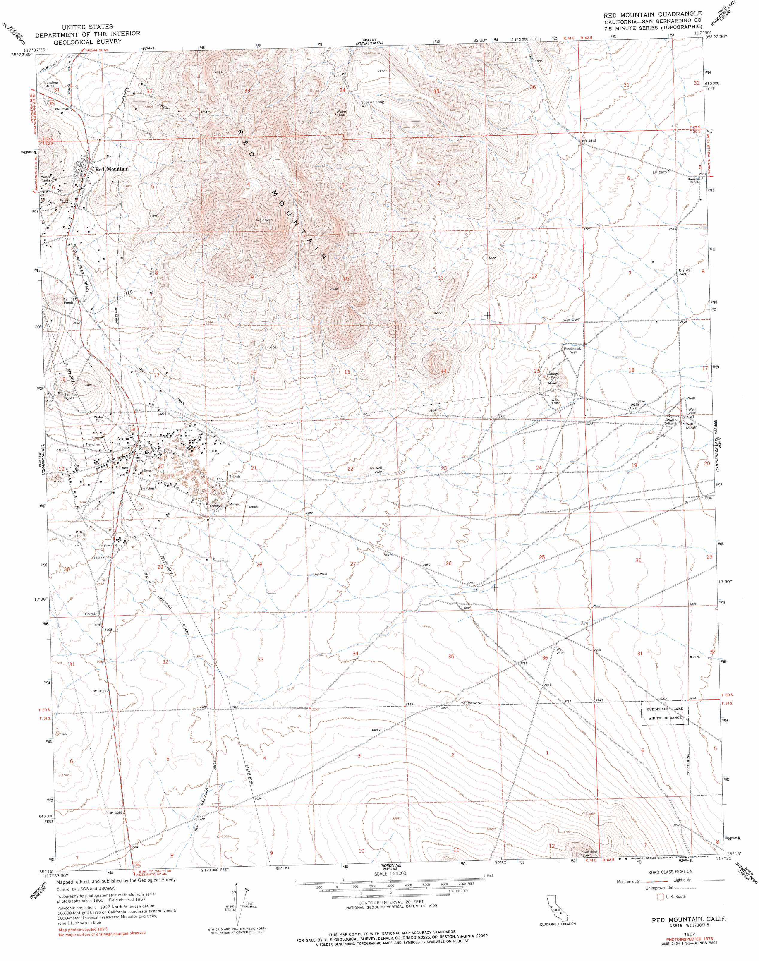
USGS Topo Quad 35117c5 - 1:24,000 scale
| Topo Map Name: | Red Mountain |
| USGS Topo Quad ID: | 35117c5 |
| Print Size: | ca. 21 1/4" wide x 27" high |
| Southeast Coordinates: | 35.25° N latitude / 117.5° W longitude |
| Map Center Coordinates: | 35.3125° N latitude / 117.5625° W longitude |
| U.S. State: | CA |
| Filename: | o35117c5.jpg |
| Download Map JPG Image: | Red Mountain topo map 1:24,000 scale |
| Map Type: | Topographic |
| Topo Series: | 7.5´ |
| Map Scale: | 1:24,000 |
| Source of Map Images: | United States Geological Survey (USGS) |
| Alternate Map Versions: |
Red Mountain CA 1967, updated 1969 Download PDF Buy paper map Red Mountain CA 1967, updated 1978 Download PDF Buy paper map Red Mountain CA 1967, updated 1978 Download PDF Buy paper map Red Mountain CA 2012 Download PDF Buy paper map Red Mountain CA 2015 Download PDF Buy paper map |
1:24,000 Topo Quads surrounding Red Mountain
Inyokern Se |
Ridgecrest South |
Spangler Hills West |
Spangler Hills East |
Christmas Canyon |
Garlock |
El Paso Peaks |
Klinker Mountain |
West Of Black Hills |
Black Hills |
Saltdale Se |
Johannesburg |
Red Mountain |
Cuddeback Lake |
Blackwater Well |
Galileo Hill |
Boron Nw |
Boron Ne |
Fremont Peak |
Bird Spring |
North Edwards |
Boron |
Saddleback Mountain |
The Buttes |
Lockhart |
> Back to 35117a1 at 1:100,000 scale
> Back to 35116a1 at 1:250,000 scale
> Back to U.S. Topo Maps home
Red Mountain topo map: Gazetteer
Red Mountain: Mines
Saint Elmo Mine elevation 965m 3166′Red Mountain: Populated Places
Atolia elevation 1006m 3300′Red Mountain elevation 1098m 3602′
Saint Elmo (historical) elevation 971m 3185′
Red Mountain: Springs
Squaw Spring elevation 1055m 3461′Red Mountain: Summits
Red Mountain elevation 1580m 5183′Red Mountain: Wells
Blackhawk Well elevation 810m 2657′Squaw Spring Well elevation 1078m 3536′
Red Mountain digital topo map on disk
Buy this Red Mountain topo map showing relief, roads, GPS coordinates and other geographical features, as a high-resolution digital map file on DVD:
Southern Sierra Nevada, California & Southern Nevada
Buy digital topo maps: Southern Sierra Nevada, California & Southern Nevada