Kettleman Plain Topo Map California
To zoom in, hover over the map of Kettleman Plain
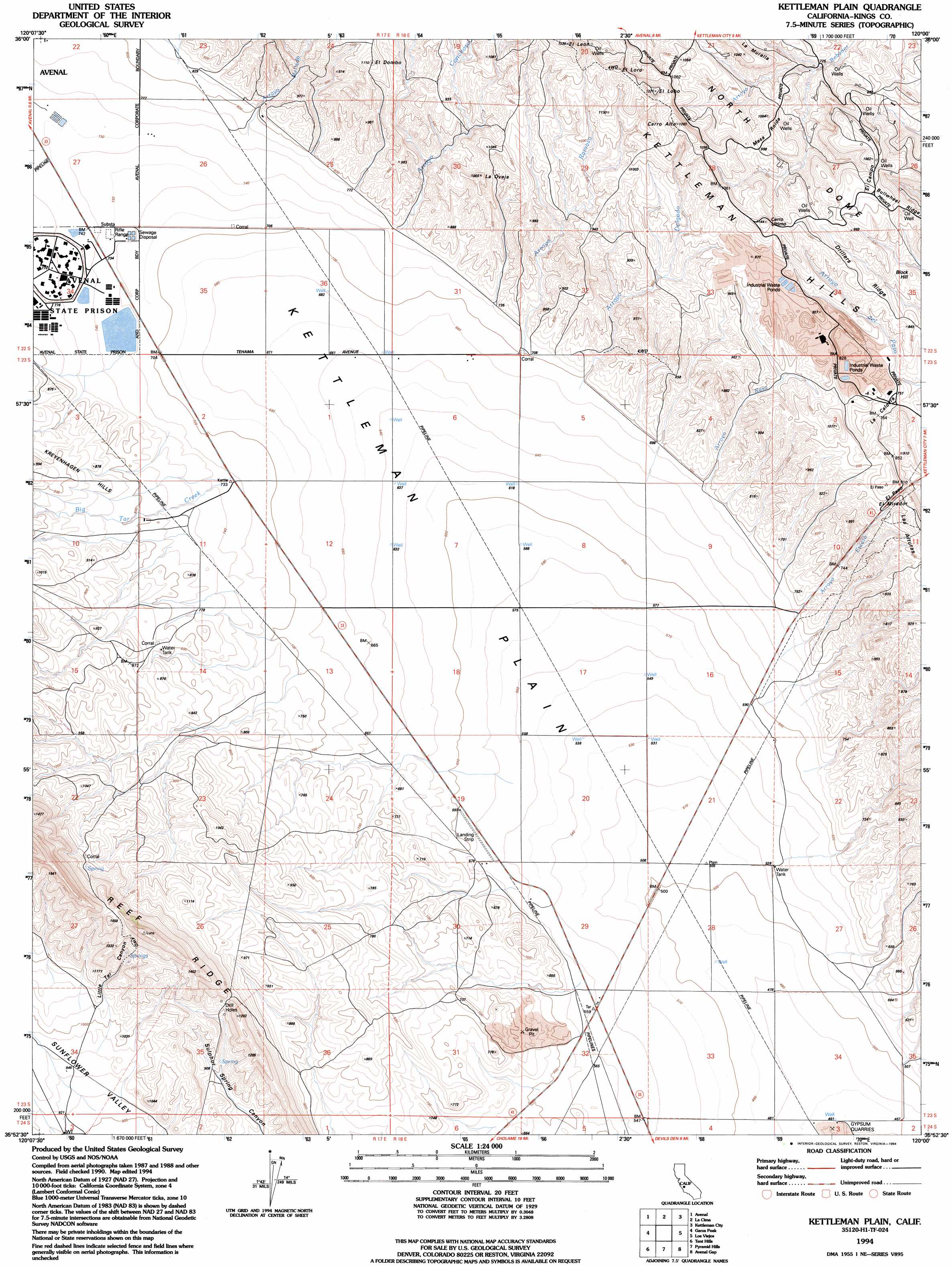
USGS Topo Quad 35120h1 - 1:24,000 scale
| Topo Map Name: | Kettleman Plain |
| USGS Topo Quad ID: | 35120h1 |
| Print Size: | ca. 21 1/4" wide x 27" high |
| Southeast Coordinates: | 35.875° N latitude / 120° W longitude |
| Map Center Coordinates: | 35.9375° N latitude / 120.0625° W longitude |
| U.S. State: | CA |
| Filename: | o35120h1.jpg |
| Download Map JPG Image: | Kettleman Plain topo map 1:24,000 scale |
| Map Type: | Topographic |
| Topo Series: | 7.5´ |
| Map Scale: | 1:24,000 |
| Source of Map Images: | United States Geological Survey (USGS) |
| Alternate Map Versions: |
Kettleman Plain CA 1950, updated 1950 Download PDF Buy paper map Kettleman Plain CA 1953, updated 1956 Download PDF Buy paper map Kettleman Plain CA 1953, updated 1983 Download PDF Buy paper map Kettleman Plain CA 1994, updated 1994 Download PDF Buy paper map Kettleman Plain CA 2012 Download PDF Buy paper map Kettleman Plain CA 2015 Download PDF Buy paper map |
1:24,000 Topo Quads surrounding Kettleman Plain
Coalinga |
Guijarral Hills |
Huron |
Westhaven |
Stratford |
Kreyenhagen Hills |
Avenal |
La Cima |
Kettleman City |
Stratford Se |
The Dark Hole |
Garza Peak |
Kettleman Plain |
Los Viejos |
Dudley Ridge |
Cholame Valley |
Tent Hills |
Pyramid Hills |
Avenal Gap |
West Camp |
Cholame |
Orchard Peak |
Sawtooth Ridge |
Emigrant Hill |
Antelope Plain |
> Back to 35120e1 at 1:100,000 scale
> Back to 35120a1 at 1:250,000 scale
> Back to U.S. Topo Maps home
Kettleman Plain topo map: Gazetteer
Kettleman Plain: Basins
La Caldera elevation 231m 757′Kettleman Plain: Gaps
El Campo elevation 313m 1026′El Paso elevation 261m 856′
Kettleman Plain: Plains
Kettleman Plain elevation 174m 570′Kettleman Plain: Populated Places
Reef Station elevation 170m 557′Kettleman Plain: Ridges
Bullwheel Ridge elevation 326m 1069′Drillers Ridge elevation 283m 928′
Kettleman Plain: Streams
Arroyo Chico elevation 262m 859′Arroyo Conchoso elevation 227m 744′
Arroyo del Camino elevation 242m 793′
Arroyo Delgado elevation 198m 649′
Arroyo Escaso elevation 209m 685′
Arroyo Mellado elevation 237m 777′
Arroyo Ramoso elevation 203m 666′
Arroyo Raso elevation 198m 649′
Arroyo Somero elevation 255m 836′
Big Tar Creek elevation 213m 698′
Kettleman Plain: Summits
Block Hill elevation 272m 892′Cerro Alto elevation 382m 1253′
Cerro Ultimo elevation 345m 1131′
Dombo elevation 337m 1105′
El Dombo elevation 334m 1095′
El Leon elevation 398m 1305′
El Lobo elevation 371m 1217′
El Loro elevation 374m 1227′
El Mirador elevation 277m 908′
La Oveja elevation 323m 1059′
Mesa Roida elevation 306m 1003′
Kettleman Plain: Valleys
Little Tar Canyon elevation 320m 1049′Kettleman Plain digital topo map on disk
Buy this Kettleman Plain topo map showing relief, roads, GPS coordinates and other geographical features, as a high-resolution digital map file on DVD: