Fentress Topo Map Virginia
To zoom in, hover over the map of Fentress
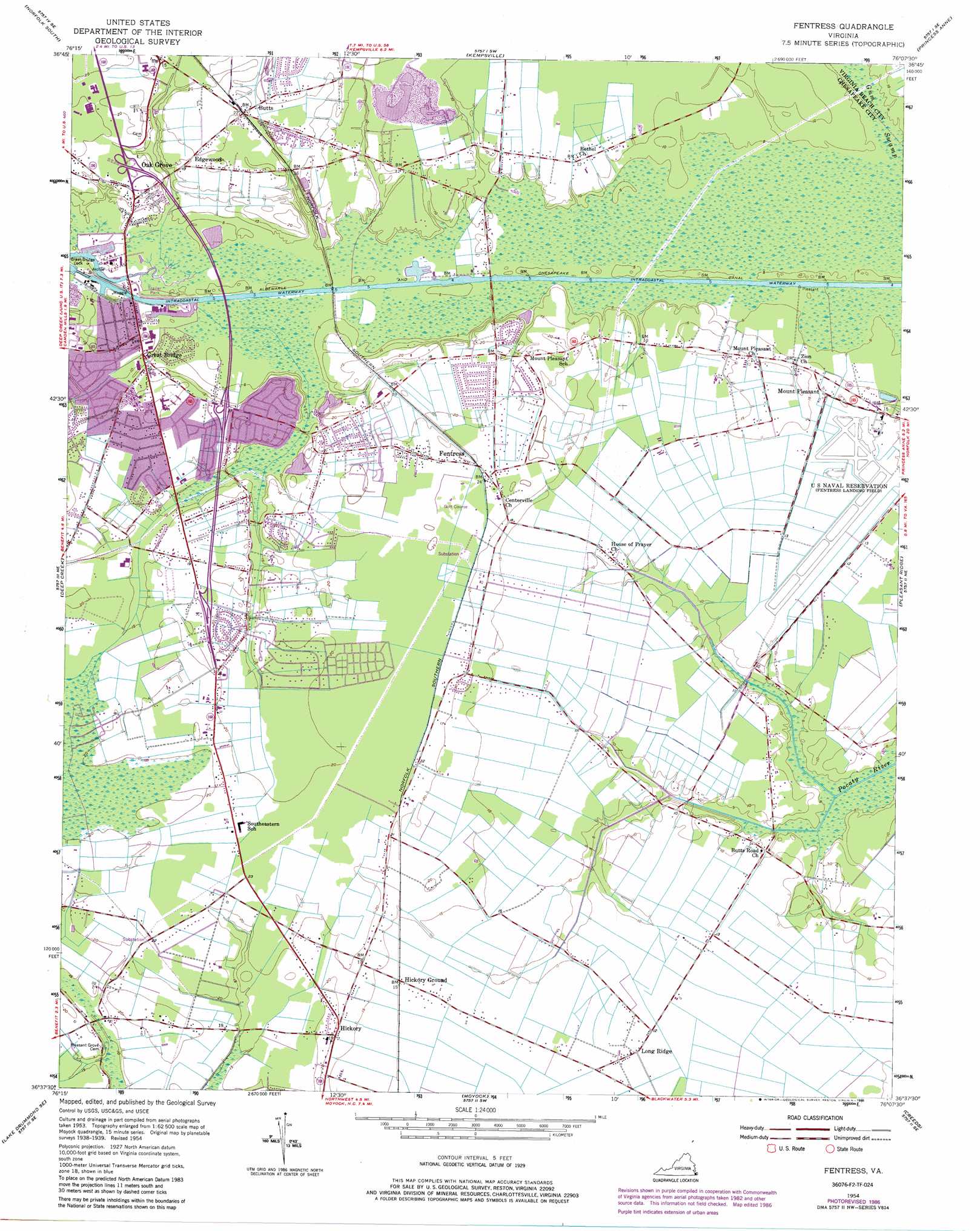
USGS Topo Quad 36076f2 - 1:24,000 scale
| Topo Map Name: | Fentress |
| USGS Topo Quad ID: | 36076f2 |
| Print Size: | ca. 21 1/4" wide x 27" high |
| Southeast Coordinates: | 36.625° N latitude / 76.125° W longitude |
| Map Center Coordinates: | 36.6875° N latitude / 76.1875° W longitude |
| U.S. State: | VA |
| Filename: | o36076f2.jpg |
| Download Map JPG Image: | Fentress topo map 1:24,000 scale |
| Map Type: | Topographic |
| Topo Series: | 7.5´ |
| Map Scale: | 1:24,000 |
| Source of Map Images: | United States Geological Survey (USGS) |
| Alternate Map Versions: |
Fentress VA 1954, updated 1956 Download PDF Buy paper map Fentress VA 1954, updated 1972 Download PDF Buy paper map Fentress VA 1954, updated 1980 Download PDF Buy paper map Fentress VA 1954, updated 1986 Download PDF Buy paper map Fentress VA 2011 Download PDF Buy paper map Fentress VA 2013 Download PDF Buy paper map Fentress VA 2016 Download PDF Buy paper map |
1:24,000 Topo Quads surrounding Fentress
Newport News South |
Norfolk North |
Little Creek |
Cape Henry |
North Virginia Beach |
Bowers Hill |
Norfolk South |
Kempsville |
Princess Anne |
Virginia Beach |
Lake Drummond Nw |
Deep Creek |
Fentress |
Pleasant Ridge |
North Bay |
Lake Drummond |
Lake Drummond Se |
Moyock |
Creeds |
Knotts Island |
Lynchs Corner |
South Mills |
Lambs Corner |
Currituck |
Barco |
> Back to 36076e1 at 1:100,000 scale
> Back to 36076a1 at 1:250,000 scale
> Back to U.S. Topo Maps home
Fentress topo map: Gazetteer
Fentress: Airports
Chesapeake General Hospital Heliport elevation 6m 19′Fentress Naval Air Landing Field elevation 4m 13′
Fentress: Dams
Great Bridge Lock elevation 2m 6′Fentress: Harbors
Atlantic Yacht Basin elevation 1m 3′Fentress: Parks
Great Bridge Lock Park elevation 2m 6′Fentress: Populated Places
Albemarle Acres elevation 6m 19′Albemarle Farms elevation 7m 22′
Battlewood Meadows elevation 7m 22′
Bridge Field elevation 6m 19′
Butts elevation 6m 19′
Edgewood elevation 4m 13′
Fentress elevation 7m 22′
Great Bridge elevation 2m 6′
Great Bridge Gardens elevation 5m 16′
Hickory elevation 6m 19′
Hutchins elevation 6m 19′
Long Ridge elevation 4m 13′
Mount Pleasant elevation 4m 13′
Mount Pleasent Heights elevation 6m 19′
Oak Grove elevation 4m 13′
Poplar Ridge elevation 6m 19′
Sign Pine (historical) elevation 3m 9′
Waterway Estates elevation 7m 22′
Fentress: Post Offices
Fentress Post Office elevation 7m 22′Great Bridge Post Office elevation 5m 16′
Fentress: Streams
Stewart Creek elevation 5m 16′Fentress: Swamps
Gum Swamp elevation 1m 3′Fentress digital topo map on disk
Buy this Fentress topo map showing relief, roads, GPS coordinates and other geographical features, as a high-resolution digital map file on DVD:
Atlantic Coast (NY, NJ, PA, DE, MD, VA, NC)
Buy digital topo maps: Atlantic Coast (NY, NJ, PA, DE, MD, VA, NC)
 map DVD")