Knotts Island Topo Map Virginia
To zoom in, hover over the map of Knotts Island
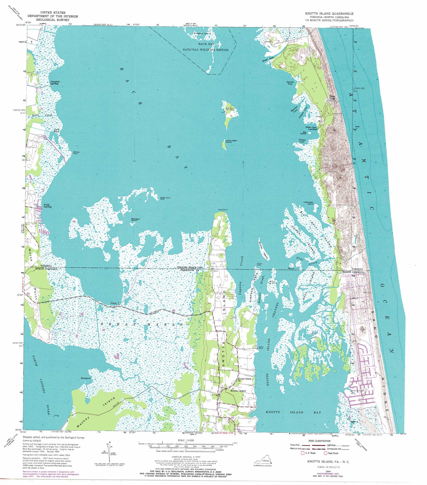
USGS Topo Quad 36075e8 - 1:24,000 scale
| Topo Map Name: | Knotts Island |
| USGS Topo Quad ID: | 36075e8 |
| Print Size: | ca. 21 1/4" wide x 27" high |
| Southeast Coordinates: | 36.5° N latitude / 75.875° W longitude |
| Map Center Coordinates: | 36.5625° N latitude / 75.9375° W longitude |
| U.S. States: | VA, NC |
| Filename: | o36075e8.jpg |
| Download Map JPG Image: | Knotts Island topo map 1:24,000 scale |
| Map Type: | Topographic |
| Topo Series: | 7.5´ |
| Map Scale: | 1:24,000 |
| Source of Map Images: | United States Geological Survey (USGS) |
| Alternate Map Versions: |
Knotts Island NC 1954, updated 1956 Download PDF Buy paper map Knotts Island NC 1954, updated 1965 Download PDF Buy paper map Knotts Island NC 1954, updated 1972 Download PDF Buy paper map Knotts Island NC 2010 Download PDF Buy paper map Knotts Island NC 2013 Download PDF Buy paper map Knotts Island NC 2016 Download PDF Buy paper map |
1:24,000 Topo Quads surrounding Knotts Island
Kempsville |
Princess Anne |
Virginia Beach |
||
Fentress |
Pleasant Ridge |
North Bay |
||
Moyock |
Creeds |
Knotts Island |
||
Lambs Corner |
Currituck |
Barco |
Corolla |
|
Elizabeth City |
Shiloh |
Coinjock |
Mossey Islands |
> Back to 36075e1 at 1:100,000 scale
> Back to 36074a1 at 1:250,000 scale
> Back to U.S. Topo Maps home
Knotts Island topo map: Gazetteer
Knotts Island: Bays
Back Bay elevation 0m 0′Back Creek elevation 0m 0′
Cowpen Cove elevation 0m 0′
Deal Creek elevation 0m 0′
Hammet Cove elevation 0m 0′
Knotts Island Bay elevation 0m 0′
Spratts Cove elevation 0m 0′
Tripps Cove elevation 0m 0′
Knotts Island: Capes
Cason Point elevation 0m 0′Knight Point elevation 0m 0′
Morse Point elevation 1m 3′
Pellitory Point elevation 0m 0′
Sedge Island Point elevation 0m 0′
Simpson Neck elevation 0m 0′
Knotts Island: Channels
Knotts Island Channel elevation 0m 0′Knotts Island: Guts
Porpoise Slough elevation 0m 0′South Inlet elevation 0m 0′
Knotts Island: Islands
Big Ball Island elevation 0m 0′Big Island elevation 0m 0′
Big Perch Island elevation 0m 0′
Buckle Island elevation -2m -7′
Cedar Island elevation 1m 3′
Deal Island elevation 0m 0′
Hammock Island elevation 0m 0′
Horse Island elevation 0m 0′
Knotts Island elevation 1m 3′
Little Ball Island elevation 0m 0′
Little Cedar Island elevation 0m 0′
Little Perch Island elevation 0m 0′
Mackay Island elevation 0m 0′
Man Island elevation 0m 0′
Manns Island elevation 0m 0′
Mon Island elevation 0m 0′
Simon Island elevation 0m 0′
Simon Island elevation 0m 0′
Simpson Island elevation 0m 0′
Smith Island elevation 0m 0′
South Buckle Island elevation -1m -4′
Knotts Island: Parks
Barbours Hill Waterfowl Management Area elevation 6m 19′False Cape State Park elevation 3m 9′
Knotts Island Ruritan Park elevation 1m 3′
Pocahontas Waterfowl Management Area elevation 0m 0′
Trojan Waterfowl Management Area elevation 0m 0′
Knotts Island: Populated Places
Campbells Landing elevation 0m 0′Corys elevation 1m 3′
False Cape Landing elevation 0m 0′
Ferguson Mobile Home Park elevation 4m 13′
Hemsath Mobile Home Park elevation 3m 9′
Knotts Island elevation 3m 9′
North End (historical) elevation 0m 0′
Public Landing elevation 0m 0′
Knotts Island: Post Offices
Knotts Island Post Office elevation 3m 9′Knotts Island: Reservoirs
Carol Pond elevation -4m -14′Knotts Island: Streams
Capsies Creek elevation 0m 0′Devil Creek elevation 0m 0′
Porpoise Slough elevation 0m 0′
Knotts Island: Swamps
Great Marsh elevation 0m 0′Knotts Island digital topo map on disk
Buy this Knotts Island topo map showing relief, roads, GPS coordinates and other geographical features, as a high-resolution digital map file on DVD:
Atlantic Coast (NY, NJ, PA, DE, MD, VA, NC)
Buy digital topo maps: Atlantic Coast (NY, NJ, PA, DE, MD, VA, NC)
 map DVD")