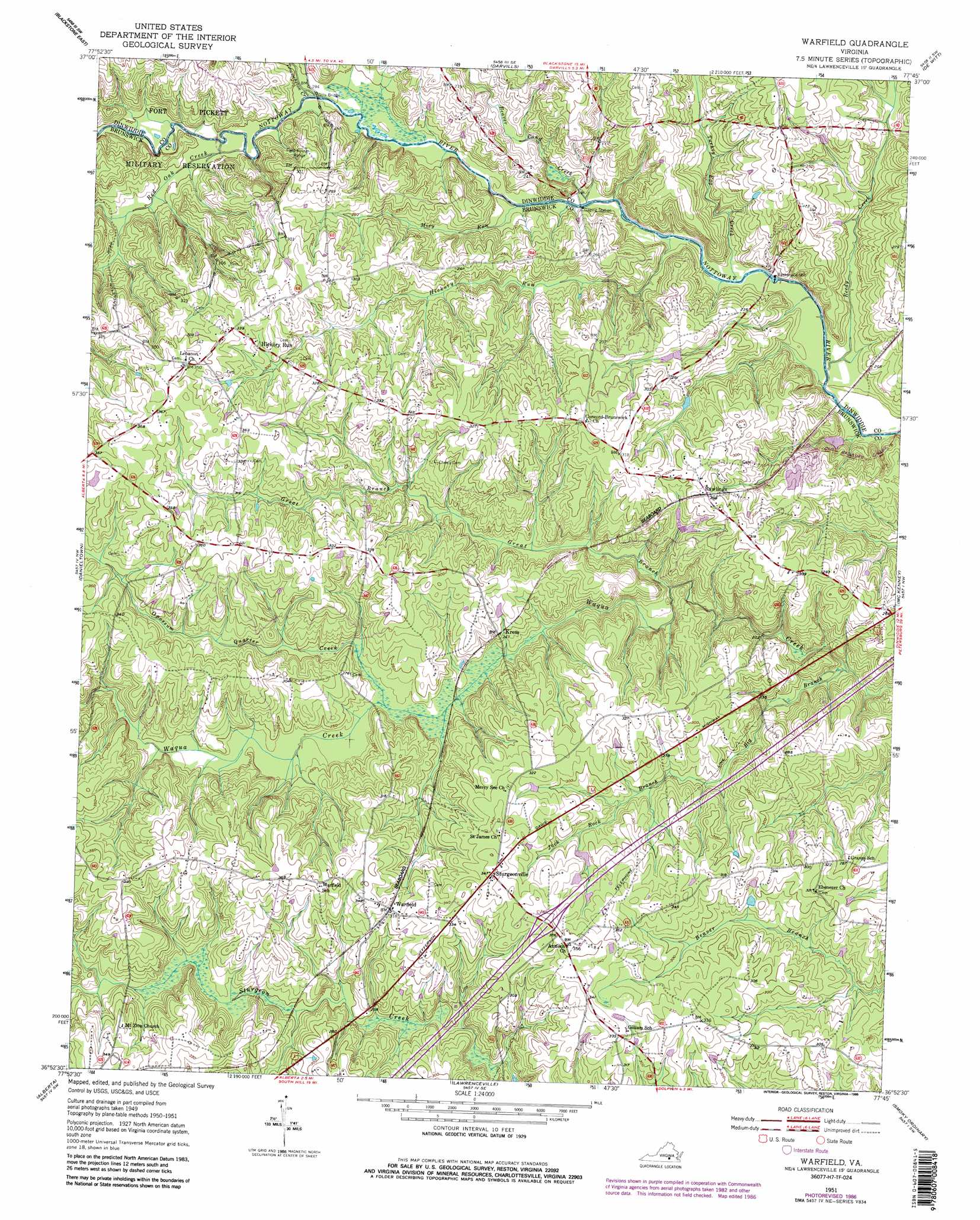
Warfield Topo Map Virginia
To zoom in, hover over the map of Warfield
USGS Topo Quad 36077h7 - 1:24,000 scale
| Topo Map Name: | Warfield |
| USGS Topo Quad ID: | 36077h7 |
| Print Size: | ca. 21 1/4" wide x 27" high |
| Southeast Coordinates: | 36.875° N latitude / 77.75° W longitude |
| Map Center Coordinates: | 36.9375° N latitude / 77.8125° W longitude |
| U.S. State: | VA |
| Filename: | o36077h7.jpg |
| Download Map JPG Image: | Warfield topo map 1:24,000 scale |
| Map Type: | Topographic |
| Topo Series: | 7.5´ |
| Map Scale: | 1:24,000 |
| Source of Map Images: | United States Geological Survey (USGS) |
| Alternate Map Versions: |
Warfield VA 1951, updated 1952 Download PDF Buy paper map Warfield VA 1951, updated 1970 Download PDF Buy paper map Warfield VA 1951, updated 1986 Download PDF Buy paper map Warfield VA 1951, updated 1986 Download PDF Buy paper map Warfield VA 2010 Download PDF Buy paper map Warfield VA 2013 Download PDF Buy paper map Warfield VA 2016 Download PDF Buy paper map |
1:24,000 Topo Quads surrounding Warfield
Crewe East |
Wellville |
Hebron |
Church Road |
Sutherland |
Blackstone West |
Blackstone East |
Darvills |
De Witt |
Dinwiddie |
Kenbridge East |
Danieltown |
Warfield |
Mckenney |
Cherry Hill |
Forksville |
Alberta |
Lawrenceville |
Smoky Ordinary |
Purdy |
La Crosse |
White Plains |
Powellton |
Ante |
Emporia |
> Back to 36077e1 at 1:100,000 scale
> Back to 36076a1 at 1:250,000 scale
> Back to U.S. Topo Maps home
Warfield topo map: Gazetteer
Warfield: Airports
Baskerville Airport elevation 89m 291′Warfield: Bridges
Gills Bridge elevation 57m 187′Harpers Bridge elevation 54m 177′
Jones Bridge elevation 52m 170′
Warfield: Crossings
Interchange 34 elevation 106m 347′Warfield: Populated Places
Baskerville Mill elevation 55m 180′Champ elevation 61m 200′
Concord elevation 98m 321′
Harpers elevation 91m 298′
Hickory Run elevation 94m 308′
Kress elevation 74m 242′
Rawlings elevation 91m 298′
Sturgeonville elevation 106m 347′
Warfield elevation 95m 311′
Warfield: Streams
Beaver Pond Creek elevation 54m 177′Big Branch elevation 54m 177′
Great Branch elevation 61m 200′
Hickory Run elevation 54m 177′
Jack Rock Branch elevation 72m 236′
Miry Run elevation 54m 177′
Opossum Quarter Creek elevation 68m 223′
Red Oak Creek elevation 58m 190′
Reedy Creek elevation 51m 167′
Tommeheton Creek elevation 58m 190′
Turkey Egg Creek elevation 52m 170′
Warfield digital topo map on disk
Buy this Warfield topo map showing relief, roads, GPS coordinates and other geographical features, as a high-resolution digital map file on DVD:
Atlantic Coast (NY, NJ, PA, DE, MD, VA, NC)
Buy digital topo maps: Atlantic Coast (NY, NJ, PA, DE, MD, VA, NC)
 map DVD")