Inola Topo Map Oklahoma
To zoom in, hover over the map of Inola
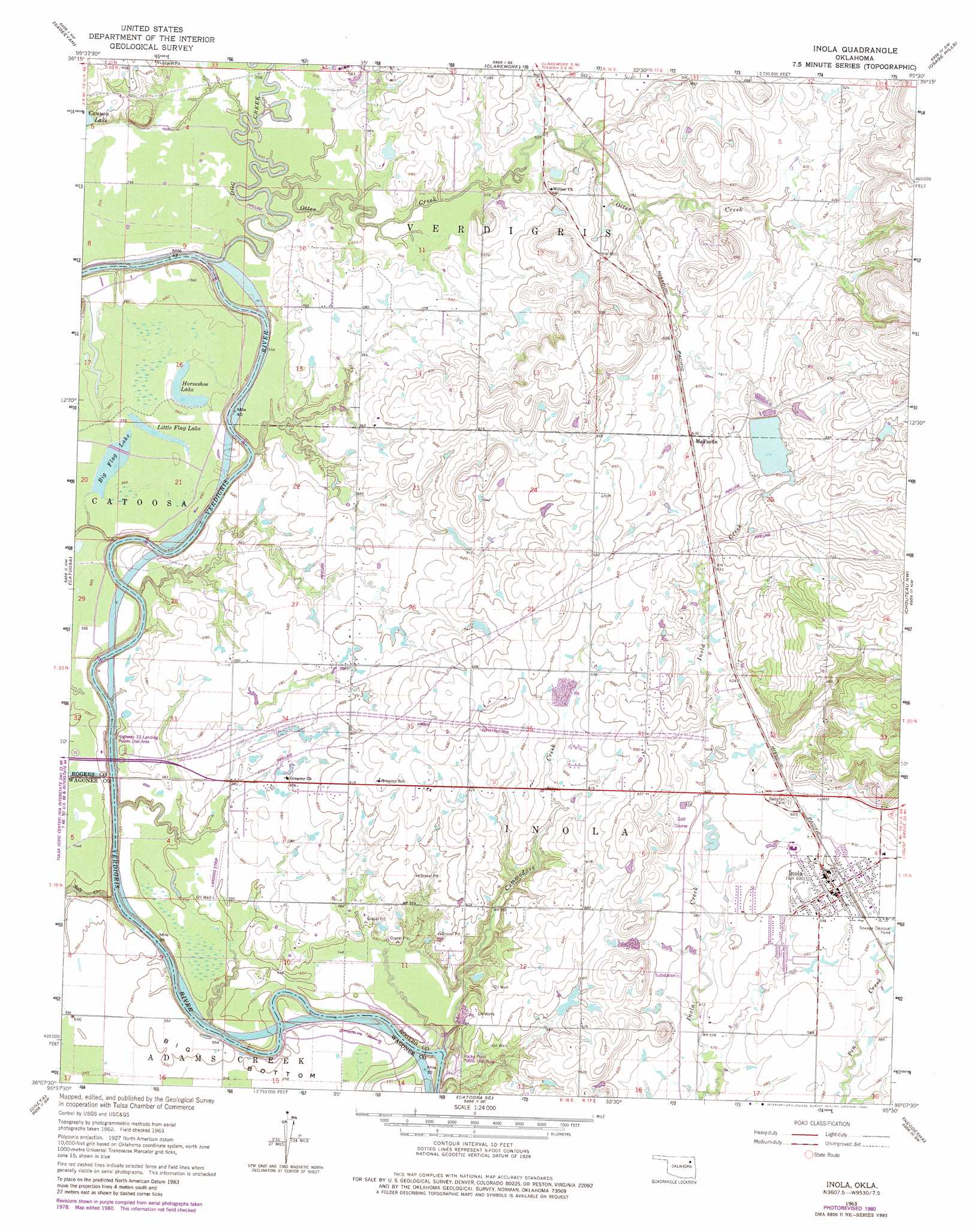
USGS Topo Quad 36095b5 - 1:24,000 scale
| Topo Map Name: | Inola |
| USGS Topo Quad ID: | 36095b5 |
| Print Size: | ca. 21 1/4" wide x 27" high |
| Southeast Coordinates: | 36.125° N latitude / 95.5° W longitude |
| Map Center Coordinates: | 36.1875° N latitude / 95.5625° W longitude |
| U.S. State: | OK |
| Filename: | o36095b5.jpg |
| Download Map JPG Image: | Inola topo map 1:24,000 scale |
| Map Type: | Topographic |
| Topo Series: | 7.5´ |
| Map Scale: | 1:24,000 |
| Source of Map Images: | United States Geological Survey (USGS) |
| Alternate Map Versions: |
Inola OK 1963, updated 1964 Download PDF Buy paper map Inola OK 1963, updated 1976 Download PDF Buy paper map Inola OK 1963, updated 1980 Download PDF Buy paper map Inola OK 2010 Download PDF Buy paper map Inola OK 2013 Download PDF Buy paper map Inola OK 2016 Download PDF Buy paper map |
1:24,000 Topo Quads surrounding Inola
Collinsville Ne |
Oologah |
Foyil |
Bushyhead |
Adair |
Collinsville |
Sageeyah |
Claremore |
Osage Hills |
Pryor |
Mingo |
Catoosa |
Inola |
Choteau Nw |
Chouteau |
Broken Arrow |
Oneta |
Catoosa Se |
Neodesha |
Rocky Point |
Leonard |
Coweta |
Red Bird |
Wagoner West |
Wagoner East |
> Back to 36095a1 at 1:100,000 scale
> Back to 36094a1 at 1:250,000 scale
> Back to U.S. Topo Maps home
Inola topo map: Gazetteer
Inola: Airports
Dobies Airport elevation 214m 702′Gilstrap Field elevation 175m 574′
Night Hawk Airpatch elevation 205m 672′
Inola: Dams
Inola Lake Dam elevation 199m 652′Oknoname 131006 Dam elevation 171m 561′
Inola: Lakes
Big Flag Lake elevation 168m 551′Horseshoe Lake elevation 169m 554′
Little Flag Lake elevation 169m 554′
Inola: Parks
Rocky Point Public Use Area elevation 173m 567′Inola: Populated Places
Gregory elevation 197m 646′Inola elevation 183m 600′
McFarlin elevation 191m 626′
Inola: Reservoirs
Canyon Lake elevation 173m 567′Inola Lake elevation 199m 652′
Oknoname 131006 Reservoir elevation 171m 561′
Inola: Streams
Commodore Creek elevation 157m 515′Dog Creek elevation 161m 528′
Otter Creek elevation 166m 544′
Salt Creek elevation 158m 518′
Inola digital topo map on disk
Buy this Inola topo map showing relief, roads, GPS coordinates and other geographical features, as a high-resolution digital map file on DVD: