Lithium Topo Map Missouri
To zoom in, hover over the map of Lithium
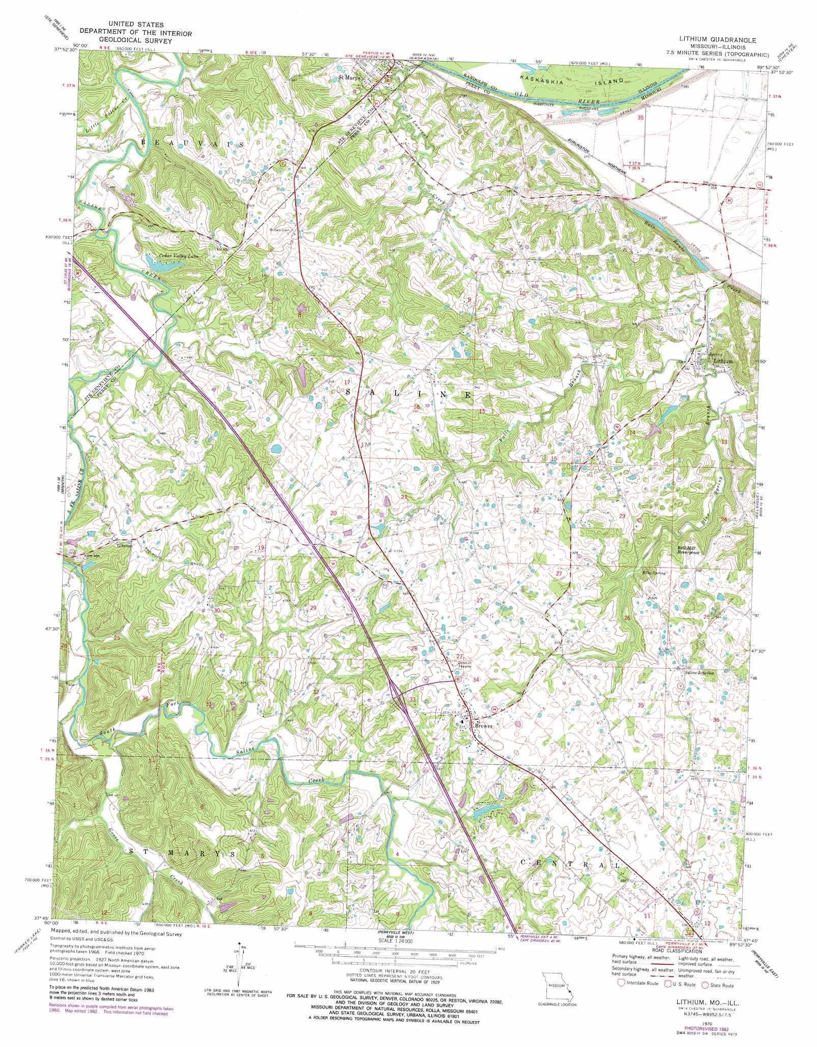
USGS Topo Quad 37089g8 - 1:24,000 scale
| Topo Map Name: | Lithium |
| USGS Topo Quad ID: | 37089g8 |
| Print Size: | ca. 21 1/4" wide x 27" high |
| Southeast Coordinates: | 37.75° N latitude / 89.875° W longitude |
| Map Center Coordinates: | 37.8125° N latitude / 89.9375° W longitude |
| U.S. States: | MO, IL |
| Filename: | o37089g8.jpg |
| Download Map JPG Image: | Lithium topo map 1:24,000 scale |
| Map Type: | Topographic |
| Topo Series: | 7.5´ |
| Map Scale: | 1:24,000 |
| Source of Map Images: | United States Geological Survey (USGS) |
| Alternate Map Versions: |
Lithium MO 1970, updated 1972 Download PDF Buy paper map Lithium MO 1970, updated 1982 Download PDF Buy paper map Lithium MO 1993, updated 1996 Download PDF Buy paper map Lithium MO 2012 Download PDF Buy paper map Lithium MO 2015 Download PDF Buy paper map |
1:24,000 Topo Quads surrounding Lithium
Bloomsdale |
Prairie Du Rocher |
Evansville |
Walsh |
Steeleville |
Weingarten |
Sainte Genevieve |
Kaskaskia |
Chester |
Welge |
Coffman |
Minnith |
Lithium |
Belgique |
Rockwood |
Womack |
Parker Lake |
Perryville West |
Perryville East |
Crosstown |
Higdon |
Patton |
Sedgewickville |
Friedheim |
Oak Ridge |
> Back to 37089e1 at 1:100,000 scale
> Back to 37088a1 at 1:250,000 scale
> Back to U.S. Topo Maps home
Lithium topo map: Gazetteer
Lithium: Bends
Saint Marys Bend elevation 151m 495′Lithium: Dams
Cedar Valley Lake Dam elevation 124m 406′Circle K Dam elevation 143m 469′
Ellis Lake Dam elevation 128m 419′
Lach Difani Dam elevation 145m 475′
Lakenan Lake Dam elevation 125m 410′
Rock Valley Lake Dam elevation 138m 452′
Lithium: Lakes
Cedar Valley Lake elevation 124m 406′Lithium: Populated Places
Brewer elevation 178m 583′Giboney elevation 153m 501′
Lithium elevation 116m 380′
Saline Junction elevation 162m 531′
Lithium: Reservoirs
Circle K Ranch Lake elevation 143m 469′Rock Valley Lake elevation 138m 452′
Lithium: Springs
Ball Mill Resurgence elevation 145m 475′Blue Spring elevation 125m 410′
Lithium Spring elevation 118m 387′
Lithium: Streams
Blue Spring Branch elevation 113m 370′Cedar Fork elevation 122m 400′
Colfelt Branch elevation 122m 400′
Falls Branch elevation 120m 393′
Goose Creek elevation 121m 396′
Little Saline Creek elevation 114m 374′
Saint Laurent Creek elevation 109m 357′
Lithium: Valleys
Guittar Hollow elevation 122m 400′Lithium digital topo map on disk
Buy this Lithium topo map showing relief, roads, GPS coordinates and other geographical features, as a high-resolution digital map file on DVD: