Knob Lick Topo Map Missouri
To zoom in, hover over the map of Knob Lick
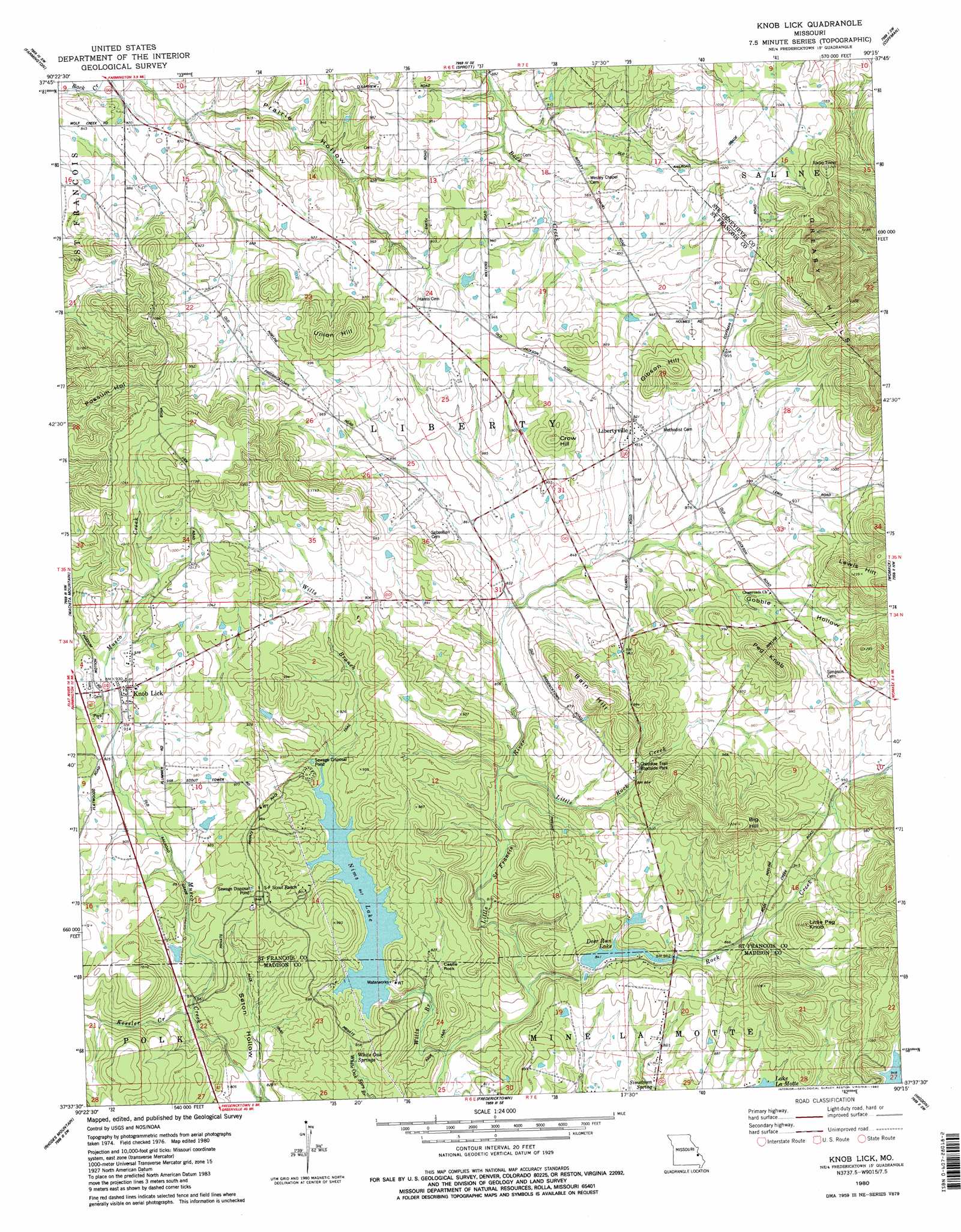
USGS Topo Quad 37090f3 - 1:24,000 scale
| Topo Map Name: | Knob Lick |
| USGS Topo Quad ID: | 37090f3 |
| Print Size: | ca. 21 1/4" wide x 27" high |
| Southeast Coordinates: | 37.625° N latitude / 90.25° W longitude |
| Map Center Coordinates: | 37.6875° N latitude / 90.3125° W longitude |
| U.S. State: | MO |
| Filename: | o37090f3.jpg |
| Download Map JPG Image: | Knob Lick topo map 1:24,000 scale |
| Map Type: | Topographic |
| Topo Series: | 7.5´ |
| Map Scale: | 1:24,000 |
| Source of Map Images: | United States Geological Survey (USGS) |
| Alternate Map Versions: |
Knob Lick MO 1980, updated 1980 Download PDF Buy paper map Knob Lick MO 1980, updated 1980 Download PDF Buy paper map Knob Lick MO 2011 Download PDF Buy paper map Knob Lick MO 2015 Download PDF Buy paper map |
1:24,000 Topo Quads surrounding Knob Lick
Bonne Terre |
French Village |
Lawrenceton |
Weingarten |
Sainte Genevieve |
Flat River |
Farmington |
Sprott |
Coffman |
Minnith |
Iron Mountain Lake |
Wachita Mountain |
Knob Lick |
Womack |
Parker Lake |
Lake Killarney |
Rhodes Mountain |
Fredericktown |
Higdon |
Patton |
Des Arc Ne |
Rock Pile Mountain |
Cherokee Pass |
Marquand |
Hurricane |
> Back to 37090e1 at 1:100,000 scale
> Back to 37090a1 at 1:250,000 scale
> Back to U.S. Topo Maps home
Knob Lick topo map: Gazetteer
Knob Lick: Dams
Deer Run Lake Dam elevation 253m 830′Fawn Lake Dam elevation 262m 859′
Lost Valley Lake Dam elevation 290m 951′
Mine la Motte Dam elevation 261m 856′
Nims Lake Dam elevation 259m 849′
Knob Lick: Parks
Cherokee Trail Roadside Park elevation 271m 889′Knob Lick: Pillars
Castle Rock elevation 250m 820′Knob Lick: Populated Places
Knob Lick elevation 287m 941′Libertyville elevation 279m 915′
Knob Lick: Ranges
Greasy Hills elevation 360m 1181′Knob Lick: Reservoirs
Deer Run Lake elevation 253m 830′Eugene D Nims Lake elevation 259m 849′
Fawn Lake elevation 262m 859′
Mine la Motte Reservoir elevation 261m 856′
Nims Lake elevation 251m 823′
Knob Lick: Springs
White Oak Spring elevation 252m 826′Knob Lick: Streams
Kessler Creek elevation 255m 836′Little Rock Creek elevation 244m 800′
Plum Branch elevation 255m 836′
Rock Creek elevation 239m 784′
Wills Branch elevation 233m 764′
Knob Lick: Summits
Bain Hill elevation 336m 1102′Big Hill elevation 364m 1194′
Crow Hill elevation 311m 1020′
Gibson Hill elevation 331m 1085′
Lewis Hill elevation 374m 1227′
Little Peg Knob elevation 323m 1059′
Peg Knob elevation 334m 1095′
Union Hill elevation 349m 1145′
Knob Lick: Valleys
Gobble Hollow elevation 263m 862′Prairie Hollow elevation 261m 856′
Seton Hollow elevation 238m 780′
Knob Lick digital topo map on disk
Buy this Knob Lick topo map showing relief, roads, GPS coordinates and other geographical features, as a high-resolution digital map file on DVD: