Rock Pile Mountain Topo Map Missouri
To zoom in, hover over the map of Rock Pile Mountain
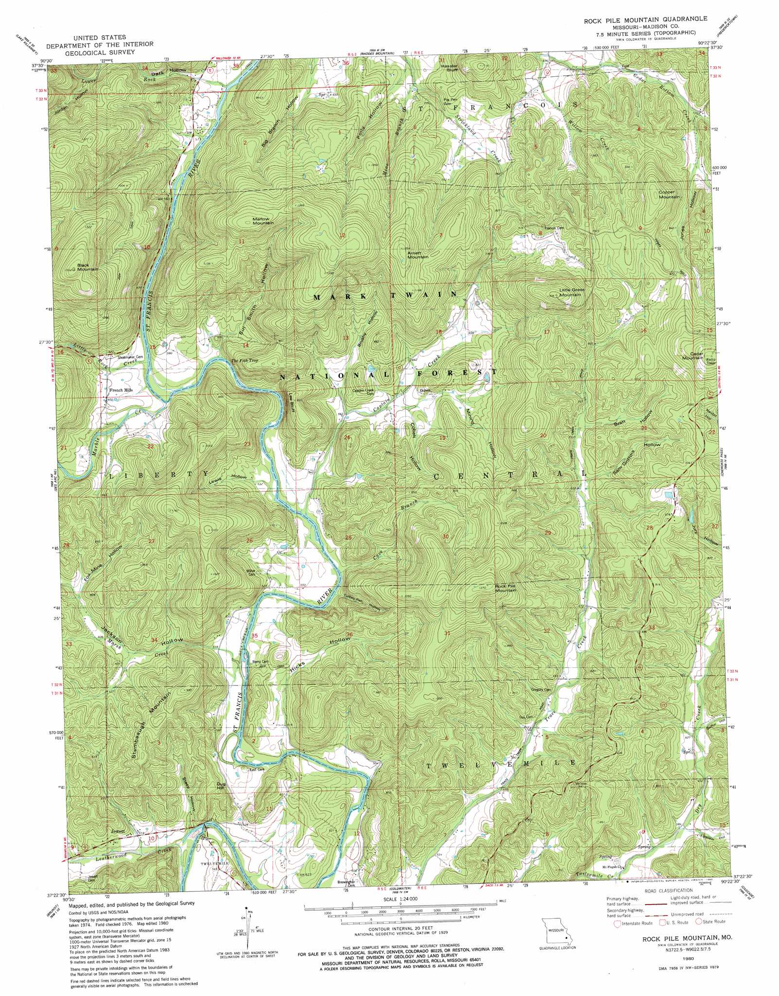
USGS Topo Quad 37090d4 - 1:24,000 scale
| Topo Map Name: | Rock Pile Mountain |
| USGS Topo Quad ID: | 37090d4 |
| Print Size: | ca. 21 1/4" wide x 27" high |
| Southeast Coordinates: | 37.375° N latitude / 90.375° W longitude |
| Map Center Coordinates: | 37.4375° N latitude / 90.4375° W longitude |
| U.S. State: | MO |
| Filename: | o37090d4.jpg |
| Download Map JPG Image: | Rock Pile Mountain topo map 1:24,000 scale |
| Map Type: | Topographic |
| Topo Series: | 7.5´ |
| Map Scale: | 1:24,000 |
| Source of Map Images: | United States Geological Survey (USGS) |
| Alternate Map Versions: |
Rock Pile Mountain MO 1980, updated 1980 Download PDF Buy paper map Rock Pile Mountain MO 2000, updated 2003 Download PDF Buy paper map Rock Pile Mountain MO 2011 Download PDF Buy paper map Rock Pile Mountain MO 2015 Download PDF Buy paper map |
| FStopo: | US Forest Service topo Rock Pile Mountain is available: Download FStopo PDF Download FStopo TIF |
1:24,000 Topo Quads surrounding Rock Pile Mountain
Graniteville |
Iron Mountain Lake |
Wachita Mountain |
Knob Lick |
Womack |
Ironton |
Lake Killarney |
Rhodes Mountain |
Fredericktown |
Higdon |
Glover |
Des Arc Ne |
Rock Pile Mountain |
Cherokee Pass |
Marquand |
Des Arc |
Brunot |
Coldwater |
Cascade |
Allbright |
Piedmont |
Patterson |
Greenville |
Lowndes |
Gipsy |
> Back to 37090a1 at 1:100,000 scale
> Back to 37090a1 at 1:250,000 scale
> Back to U.S. Topo Maps home
Rock Pile Mountain topo map: Gazetteer
Rock Pile Mountain: Channels
The Fish Trap elevation 159m 521′Rock Pile Mountain: Cliffs
Hassler Bluff elevation 302m 990′Lee Bluff elevation 243m 797′
Rock Pile Mountain: Dams
Henry Gaines Lake Dam elevation 295m 967′Skaggs Lake Dam elevation 183m 600′
Rock Pile Mountain: Gaps
Pig Pen Gap elevation 212m 695′Rock Pile Mountain: Populated Places
Faro elevation 178m 583′French Mills elevation 186m 610′
Marsh Creek elevation 160m 524′
Wide Ford elevation 157m 515′
Rock Pile Mountain: Streams
Captain Creek elevation 157m 515′Cave Branch elevation 155m 508′
Dry Creek elevation 168m 551′
Leatherwood Creek elevation 146m 479′
Little Rock Creek elevation 163m 534′
Lower Rock Creek elevation 169m 554′
Marble Creek elevation 169m 554′
Marsh Creek elevation 152m 498′
Mine Branch elevation 196m 643′
Willow Creek elevation 207m 679′
Rock Pile Mountain: Summits
Arnett Mountain elevation 379m 1243′Black Mountain elevation 436m 1430′
Cedar Mountain elevation 403m 1322′
Copper Mountain elevation 361m 1184′
Dug Hill elevation 208m 682′
Little Grass Mountain elevation 394m 1292′
Marlow Mountain elevation 418m 1371′
Rock Pile Mountain elevation 373m 1223′
Stumbeaugh Mountain elevation 301m 987′
Rock Pile Mountain: Valleys
Ballew Hollow elevation 178m 583′Bill Smith Hollow elevation 160m 524′
Bratt Hollow elevation 230m 754′
Brushy Hollow elevation 171m 561′
Cobalt Hollow elevation 178m 583′
Cox Spring Hollow elevation 238m 780′
Dark Hollow elevation 169m 554′
Fox Mine Hollow elevation 194m 636′
Hicks Hollow elevation 152m 498′
Jackson Hollow elevation 152m 498′
Jones Hollow elevation 238m 780′
Jordan Hollow elevation 208m 682′
Lewis Hollow elevation 156m 511′
Mining Hollow elevation 182m 597′
Polly Hollow elevation 189m 620′
Sam Griffths Hollow elevation 220m 721′
Stacy Hollow elevation 146m 479′
Sulfur Hollow elevation 189m 620′
Turkey Pen Hollow elevation 155m 508′
Rock Pile Mountain digital topo map on disk
Buy this Rock Pile Mountain topo map showing relief, roads, GPS coordinates and other geographical features, as a high-resolution digital map file on DVD: