Sprott Topo Map Missouri
To zoom in, hover over the map of Sprott
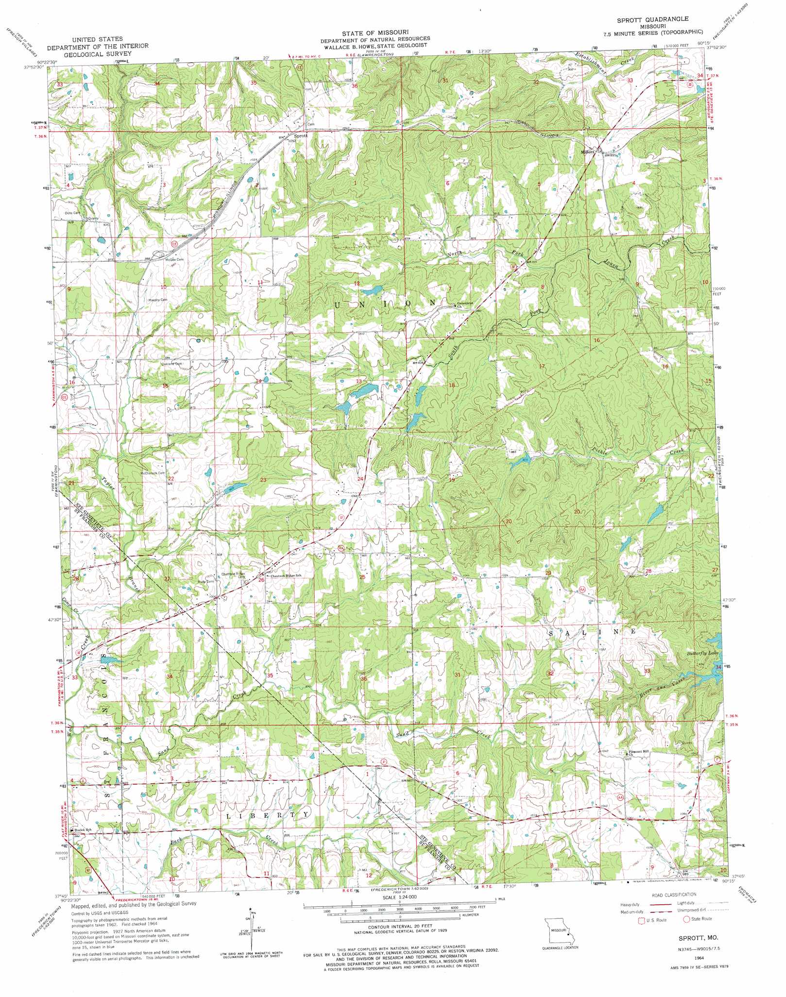
USGS Topo Quad 37090g3 - 1:24,000 scale
| Topo Map Name: | Sprott |
| USGS Topo Quad ID: | 37090g3 |
| Print Size: | ca. 21 1/4" wide x 27" high |
| Southeast Coordinates: | 37.75° N latitude / 90.25° W longitude |
| Map Center Coordinates: | 37.8125° N latitude / 90.3125° W longitude |
| U.S. State: | MO |
| Filename: | o37090g3.jpg |
| Download Map JPG Image: | Sprott topo map 1:24,000 scale |
| Map Type: | Topographic |
| Topo Series: | 7.5´ |
| Map Scale: | 1:24,000 |
| Source of Map Images: | United States Geological Survey (USGS) |
| Alternate Map Versions: |
Sprott MO 1964, updated 1965 Download PDF Buy paper map Sprott MO 1964, updated 1977 Download PDF Buy paper map Sprott MO 2011 Download PDF Buy paper map Sprott MO 2015 Download PDF Buy paper map |
1:24,000 Topo Quads surrounding Sprott
Vineland |
Halifax |
Danby |
Bloomsdale |
Prairie Du Rocher |
Bonne Terre |
French Village |
Lawrenceton |
Weingarten |
Sainte Genevieve |
Flat River |
Farmington |
Sprott |
Coffman |
Minnith |
Iron Mountain Lake |
Wachita Mountain |
Knob Lick |
Womack |
Parker Lake |
Lake Killarney |
Rhodes Mountain |
Fredericktown |
Higdon |
Patton |
> Back to 37090e1 at 1:100,000 scale
> Back to 37090a1 at 1:250,000 scale
> Back to U.S. Topo Maps home
Sprott topo map: Gazetteer
Sprott: Dams
Hintze Lake Dam elevation 285m 935′Kaeppel Lake Dam elevation 252m 826′
Kimmel Lake Dam elevation 276m 905′
Lake Genevieve Lower Dam elevation 267m 875′
Mononame 212 Dam elevation 250m 820′
Mononame 613 Dam elevation 305m 1000′
Moynihan Lake Dam elevation 263m 862′
Pineview Dam elevation 262m 859′
Sainte Genevieve Sportsman Club Lake Dam elevation 276m 905′
Schaefer Lake Dam elevation 265m 869′
Spring Hart Lake Dam elevation 246m 807′
Trautman Lake Dam elevation 254m 833′
Sprott: Populated Places
Chestnut Ridge elevation 307m 1007′Jonca elevation 274m 898′
Millers elevation 273m 895′
Pickel elevation 318m 1043′
Sprott elevation 318m 1043′
Valley Forge (historical) elevation 261m 856′
Sprott: Post Offices
Ponca Post Office (historical) elevation 273m 895′Sprott: Reservoirs
Hart Lake elevation 252m 826′Kimmel Lake elevation 276m 905′
Lake Genevieve elevation 267m 875′
Monahan Lake elevation 263m 862′
Pineview Lake elevation 262m 859′
Tragden Lake elevation 276m 905′
Trautman Lake elevation 254m 833′
Sprott: Streams
Camp Creek elevation 256m 839′North Fork Jonca Creek elevation 226m 741′
Sand Creek elevation 256m 839′
South Fork Jonca Creek elevation 229m 751′
Taylor Branch elevation 256m 839′
Sprott: Valleys
Henry Hollow elevation 248m 813′Sprott digital topo map on disk
Buy this Sprott topo map showing relief, roads, GPS coordinates and other geographical features, as a high-resolution digital map file on DVD: