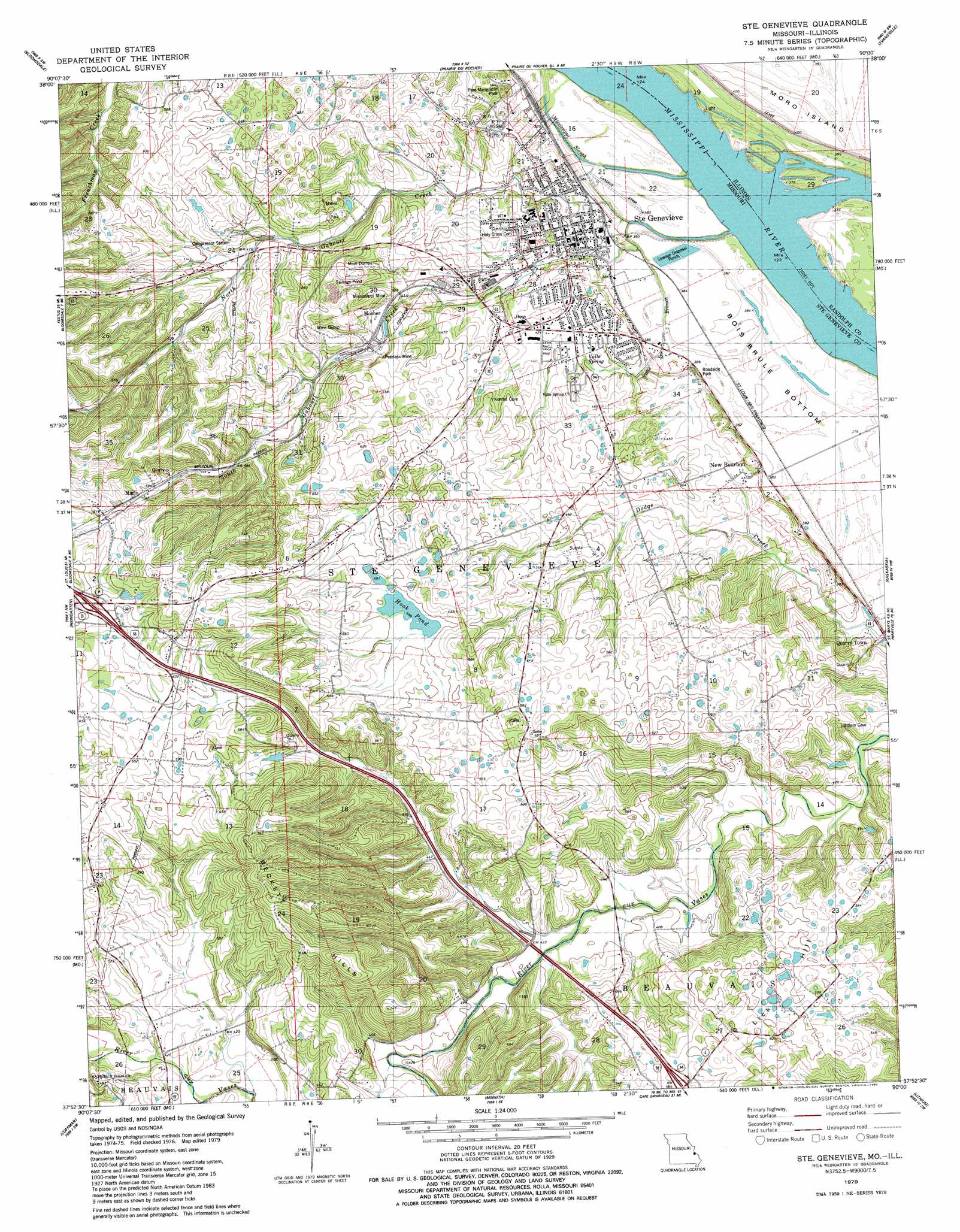
Sainte Genevieve Topo Map Missouri
To zoom in, hover over the map of Sainte Genevieve
USGS Topo Quad 37090h1 - 1:24,000 scale
| Topo Map Name: | Sainte Genevieve |
| USGS Topo Quad ID: | 37090h1 |
| Print Size: | ca. 21 1/4" wide x 27" high |
| Southeast Coordinates: | 37.875° N latitude / 90° W longitude |
| Map Center Coordinates: | 37.9375° N latitude / 90.0625° W longitude |
| U.S. States: | MO, IL |
| Filename: | o37090h1.jpg |
| Download Map JPG Image: | Sainte Genevieve topo map 1:24,000 scale |
| Map Type: | Topographic |
| Topo Series: | 7.5´ |
| Map Scale: | 1:24,000 |
| Source of Map Images: | United States Geological Survey (USGS) |
| Alternate Map Versions: |
Ste. Genevieve MO 1979, updated 1980 Download PDF Buy paper map Ste Genevieve MO 1993, updated 1996 Download PDF Buy paper map Sainte Genevieve MO 2011 Download PDF Buy paper map Sainte Genevieve MO 2015 Download PDF Buy paper map |
1:24,000 Topo Quads surrounding Sainte Genevieve
Selma |
Renault |
Ames |
Red Bud |
Baldwin |
Danby |
Bloomsdale |
Prairie Du Rocher |
Evansville |
Walsh |
Lawrenceton |
Weingarten |
Sainte Genevieve |
Kaskaskia |
Chester |
Sprott |
Coffman |
Minnith |
Lithium |
Belgique |
Knob Lick |
Womack |
Parker Lake |
Perryville West |
Perryville East |
> Back to 37090e1 at 1:100,000 scale
> Back to 37090a1 at 1:250,000 scale
> Back to U.S. Topo Maps home
Sainte Genevieve topo map: Gazetteer
Sainte Genevieve: Airports
Sainte Genevieve Flying Club elevation 116m 380′Sainte Genevieve: Areas
Big Field elevation 114m 374′Sainte Genevieve: Dams
Govro Dam elevation 201m 659′Sainte Genevieve: Flats
Bois Brule Bottom elevation 115m 377′Sainte Genevieve: Lakes
Hook Pond elevation 179m 587′Sainte Genevieve: Mines
Inkley Marble Quarry elevation 185m 606′Marlo Mine and Plant elevation 196m 643′
Mississippi Mine elevation 143m 469′
Sainte Genevieve: Parks
Pere Marquette Park elevation 128m 419′Sainte Genevieve Historic District elevation 120m 393′
Sainte Genevieve: Populated Places
Marlo elevation 179m 587′Mosher elevation 135m 442′
New Bourbon elevation 132m 433′
Quarry Town elevation 118m 387′
Saint Jude Acres elevation 121m 396′
Sainte Genevieve elevation 118m 387′
Sainte Genevieve: Ranges
Beckett Hills elevation 196m 643′Sainte Genevieve: Reservoirs
Govro Lake elevation 201m 659′Sainte Genevieve: Springs
Valle Spring elevation 121m 396′Sainte Genevieve: Streams
Mississippi Slough elevation 115m 377′North Gabouri Creek elevation 116m 380′
South Gabouri Creek elevation 116m 380′
Valle Spring Branch elevation 121m 396′
Sainte Genevieve: Summits
Lick Hill elevation 187m 613′Sainte Genevieve digital topo map on disk
Buy this Sainte Genevieve topo map showing relief, roads, GPS coordinates and other geographical features, as a high-resolution digital map file on DVD: