Springfield Topo Map Missouri
To zoom in, hover over the map of Springfield
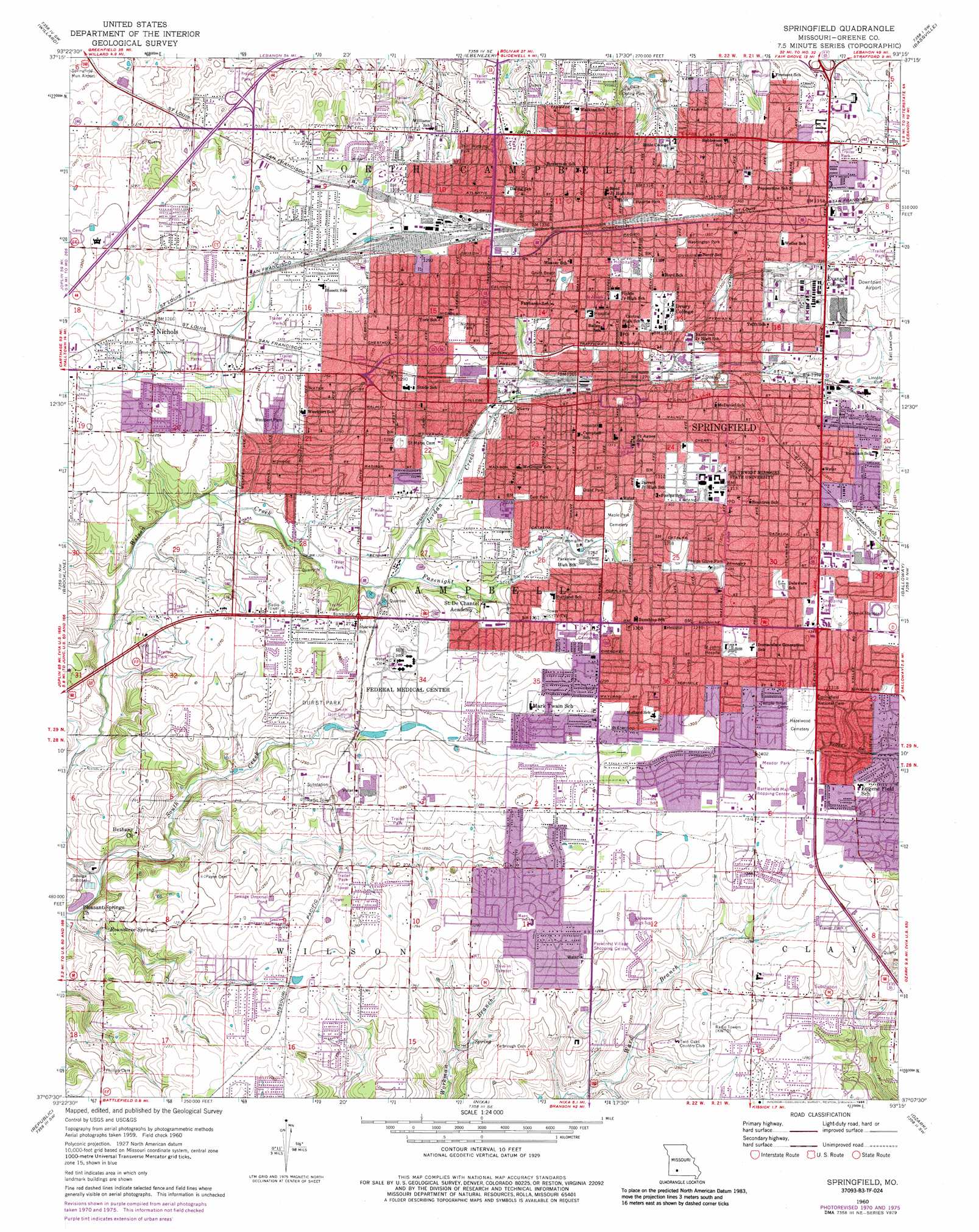
USGS Topo Quad 37093b3 - 1:24,000 scale
| Topo Map Name: | Springfield |
| USGS Topo Quad ID: | 37093b3 |
| Print Size: | ca. 21 1/4" wide x 27" high |
| Southeast Coordinates: | 37.125° N latitude / 93.25° W longitude |
| Map Center Coordinates: | 37.1875° N latitude / 93.3125° W longitude |
| U.S. State: | MO |
| Filename: | o37093b3.jpg |
| Download Map JPG Image: | Springfield topo map 1:24,000 scale |
| Map Type: | Topographic |
| Topo Series: | 7.5´ |
| Map Scale: | 1:24,000 |
| Source of Map Images: | United States Geological Survey (USGS) |
| Alternate Map Versions: |
Springfield MO 1935 Download PDF Buy paper map Springfield MO 1935, updated 1955 Download PDF Buy paper map Springfield MO 1960, updated 1961 Download PDF Buy paper map Springfield MO 1960, updated 1971 Download PDF Buy paper map Springfield MO 1960, updated 1976 Download PDF Buy paper map Springfield MO 1960, updated 1986 Download PDF Buy paper map Springfield MO 1996, updated 2000 Download PDF Buy paper map Springfield MO 2011 Download PDF Buy paper map Springfield MO 2015 Download PDF Buy paper map |
1:24,000 Topo Quads surrounding Springfield
Walnut Grove |
Morrisville |
Pleasant Hope |
Fair Grove |
Elkland |
Ash Grove |
Willard |
Ebenezer |
Bassville |
Strafford |
Halltown Ne |
Brookline |
Springfield |
Galloway |
Oak Grove Heights |
Billings |
Republic |
Nixa |
Ozark |
Rogersville |
Crane |
Hurley |
Highlandville |
Selmore |
Chadwick |
> Back to 37093a1 at 1:100,000 scale
> Back to 37092a1 at 1:250,000 scale
> Back to U.S. Topo Maps home
Springfield topo map: Gazetteer
Springfield: Airports
Ktts Heliport elevation 382m 1253′Ky-3 Heliport elevation 394m 1292′
Lester E Cox Medical Center North Heliport elevation 403m 1322′
Lester E Cox Medical Center South Heliport elevation 388m 1272′
Saint Johns Regional Health Center Heliport elevation 406m 1332′
Springfield Community Hospital Heliport elevation 393m 1289′
Springfield: Basins
Oval Sink elevation 347m 1138′Springfield: Crossings
Interchange 75 elevation 388m 1272′Interchange 77 elevation 380m 1246′
Interchange 80 A - B elevation 399m 1309′
Springfield: Parks
Carr Park elevation 388m 1272′Doling Park elevation 392m 1286′
Durst Park elevation 380m 1246′
Fassnight Park elevation 385m 1263′
Grant Beach Park elevation 396m 1299′
Grant Park elevation 389m 1276′
Kirkwood Park elevation 400m 1312′
Lafayette Park elevation 410m 1345′
Meador Park elevation 398m 1305′
Nichols Park elevation 394m 1292′
Park Central Square elevation 399m 1309′
Phelps Grove Park elevation 393m 1289′
Smith Park elevation 404m 1325′
Tom Watkins Park elevation 384m 1259′
Washington Park elevation 412m 1351′
Westport Park elevation 376m 1233′
Springfield: Populated Places
Battlefield elevation 375m 1230′Nichols elevation 384m 1259′
Springfield elevation 396m 1299′
Springfield: Springs
Rountree Spring elevation 355m 1164′Springfield: Streams
East Fork Doling Branch elevation 381m 1250′East Fork Spring Branch elevation 360m 1181′
Fassnight Creek elevation 369m 1210′
Haseltine Branch elevation 358m 1174′
Jordan Creek elevation 369m 1210′
Junction Branch elevation 377m 1236′
Nichols Branch elevation 374m 1227′
North Branch Jordan Creek elevation 387m 1269′
North Branch Wilsons Creek elevation 362m 1187′
North Fork Nichols Branch elevation 381m 1250′
North Fork Ward Branch elevation 380m 1246′
Sanford Branch elevation 379m 1243′
South Branch Jordan Creek elevation 387m 1269′
South Branch South Creek elevation 353m 1158′
South Creek elevation 346m 1135′
South Fork Nichols Branch elevation 381m 1250′
South Fork Ward Branch elevation 380m 1246′
West Fork Doling Branch elevation 381m 1250′
West Fork Spring Branch elevation 360m 1181′
Westport Branch elevation 367m 1204′
Springfield digital topo map on disk
Buy this Springfield topo map showing relief, roads, GPS coordinates and other geographical features, as a high-resolution digital map file on DVD: