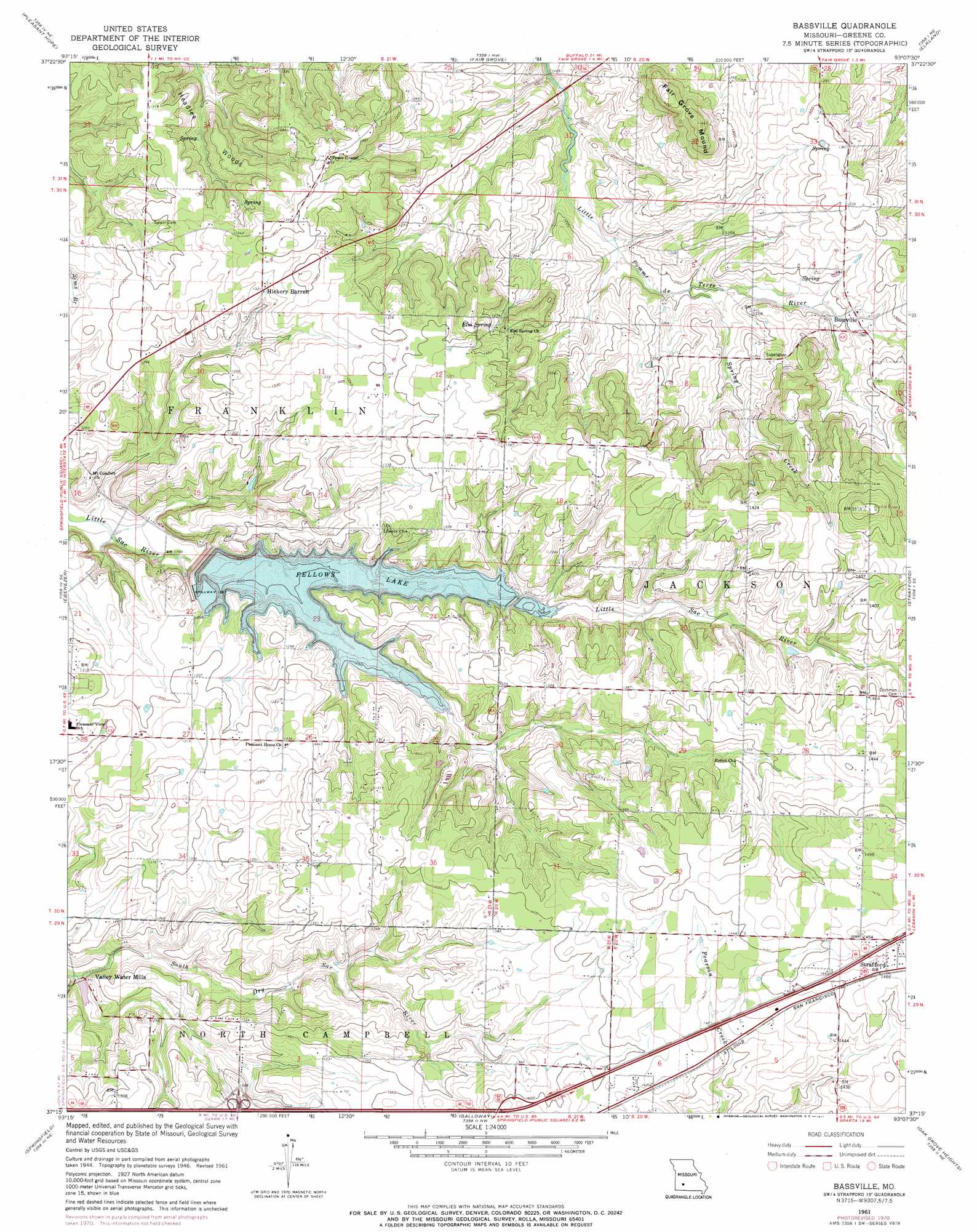
Bassville Topo Map Missouri
To zoom in, hover over the map of Bassville
USGS Topo Quad 37093c2 - 1:24,000 scale
| Topo Map Name: | Bassville |
| USGS Topo Quad ID: | 37093c2 |
| Print Size: | ca. 21 1/4" wide x 27" high |
| Southeast Coordinates: | 37.25° N latitude / 93.125° W longitude |
| Map Center Coordinates: | 37.3125° N latitude / 93.1875° W longitude |
| U.S. State: | MO |
| Filename: | o37093c2.jpg |
| Download Map JPG Image: | Bassville topo map 1:24,000 scale |
| Map Type: | Topographic |
| Topo Series: | 7.5´ |
| Map Scale: | 1:24,000 |
| Source of Map Images: | United States Geological Survey (USGS) |
| Alternate Map Versions: |
Bassville MO 1946, updated 1948 Download PDF Buy paper map Bassville MO 1961, updated 1962 Download PDF Buy paper map Bassville MO 1961, updated 1971 Download PDF Buy paper map Bassville MO 1961, updated 1971 Download PDF Buy paper map Bassville MO 2011 Download PDF Buy paper map Bassville MO 2015 Download PDF Buy paper map |
1:24,000 Topo Quads surrounding Bassville
Bolivar |
Cedar Vista |
Half Way |
Charity |
Long Lake |
Morrisville |
Pleasant Hope |
Fair Grove |
Elkland |
Beach |
Willard |
Ebenezer |
Bassville |
Strafford |
Marshfield |
Brookline |
Springfield |
Galloway |
Oak Grove Heights |
Fordland |
Republic |
Nixa |
Ozark |
Rogersville |
Bruner |
> Back to 37093a1 at 1:100,000 scale
> Back to 37092a1 at 1:250,000 scale
> Back to U.S. Topo Maps home
Bassville topo map: Gazetteer
Bassville: Dams
D and R Pipeline Construction Company Lake Dam elevation 388m 1272′Fellows Lake Dam elevation 384m 1259′
Valley Water Mills Dam elevation 367m 1204′
Bassville: Populated Places
Bassville elevation 386m 1266′Hickory Barren elevation 403m 1322′
Nogo elevation 431m 1414′
Valley Water Mills elevation 364m 1194′
Bassville: Reservoirs
Fellows Lake elevation 384m 1259′Valley Water Mill Pond elevation 367m 1204′
Bassville: Springs
Elm Spring elevation 394m 1292′Bassville: Streams
Brown Branch elevation 380m 1246′Grandview Branch elevation 361m 1184′
Mill Creek elevation 361m 1184′
Packer Branch elevation 374m 1227′
Sander Branch elevation 368m 1207′
Spring Creek elevation 364m 1194′
Bassville: Summits
Fair Grove Mound elevation 438m 1437′Bassville: Woods
Headlee Woods elevation 400m 1312′Bassville digital topo map on disk
Buy this Bassville topo map showing relief, roads, GPS coordinates and other geographical features, as a high-resolution digital map file on DVD: