Willard Topo Map Missouri
To zoom in, hover over the map of Willard
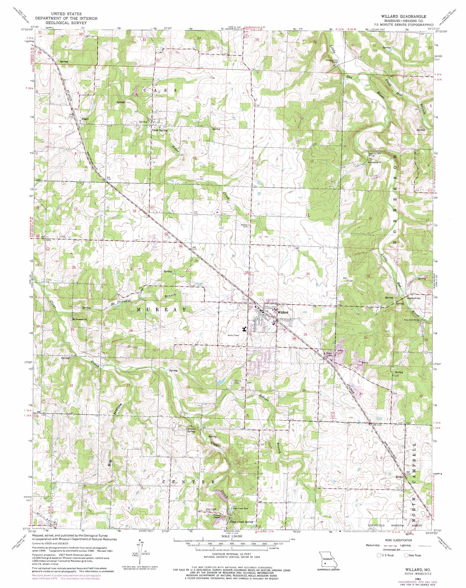
USGS Topo Quad 37093c4 - 1:24,000 scale
| Topo Map Name: | Willard |
| USGS Topo Quad ID: | 37093c4 |
| Print Size: | ca. 21 1/4" wide x 27" high |
| Southeast Coordinates: | 37.25° N latitude / 93.375° W longitude |
| Map Center Coordinates: | 37.3125° N latitude / 93.4375° W longitude |
| U.S. State: | MO |
| Filename: | o37093c4.jpg |
| Download Map JPG Image: | Willard topo map 1:24,000 scale |
| Map Type: | Topographic |
| Topo Series: | 7.5´ |
| Map Scale: | 1:24,000 |
| Source of Map Images: | United States Geological Survey (USGS) |
| Alternate Map Versions: |
Willard MO 1948 Download PDF Buy paper map Willard MO 1961, updated 1962 Download PDF Buy paper map Willard MO 1961, updated 1971 Download PDF Buy paper map Willard MO 1961, updated 1976 Download PDF Buy paper map Willard MO 1961, updated 1976 Download PDF Buy paper map Willard MO 2011 Download PDF Buy paper map Willard MO 2015 Download PDF Buy paper map |
1:24,000 Topo Quads surrounding Willard
Bona |
Aldrich |
Bolivar |
Cedar Vista |
Half Way |
Dadeville |
Walnut Grove |
Morrisville |
Pleasant Hope |
Fair Grove |
Everton |
Ash Grove |
Willard |
Ebenezer |
Bassville |
Halltown |
Halltown Ne |
Brookline |
Springfield |
Galloway |
Chesapeake |
Billings |
Republic |
Nixa |
Ozark |
> Back to 37093a1 at 1:100,000 scale
> Back to 37092a1 at 1:250,000 scale
> Back to U.S. Topo Maps home
Willard topo map: Gazetteer
Willard: Bridges
Hackney Mill Bridge elevation 305m 1000′Johnson Ford Bridge elevation 302m 990′
Knox Ford Bridge elevation 314m 1030′
Sneeds Bridge elevation 314m 1030′
Willard: Parks
Clear Creek Park elevation 349m 1145′Willard: Populated Places
Cave Spring elevation 327m 1072′Hackney elevation 306m 1003′
Pearl elevation 349m 1145′
Ritter elevation 381m 1250′
Willard elevation 377m 1236′
Willard: Springs
Brower Spring elevation 334m 1095′Clear Creek Spring elevation 353m 1158′
Willard: Streams
Flint Hill Branch elevation 302m 990′Mount Pleasant Branch elevation 311m 1020′
Rainer Branch elevation 329m 1079′
Willard: Valleys
Big Hollow elevation 320m 1049′Willard digital topo map on disk
Buy this Willard topo map showing relief, roads, GPS coordinates and other geographical features, as a high-resolution digital map file on DVD: