Andover Topo Map Kansas
To zoom in, hover over the map of Andover
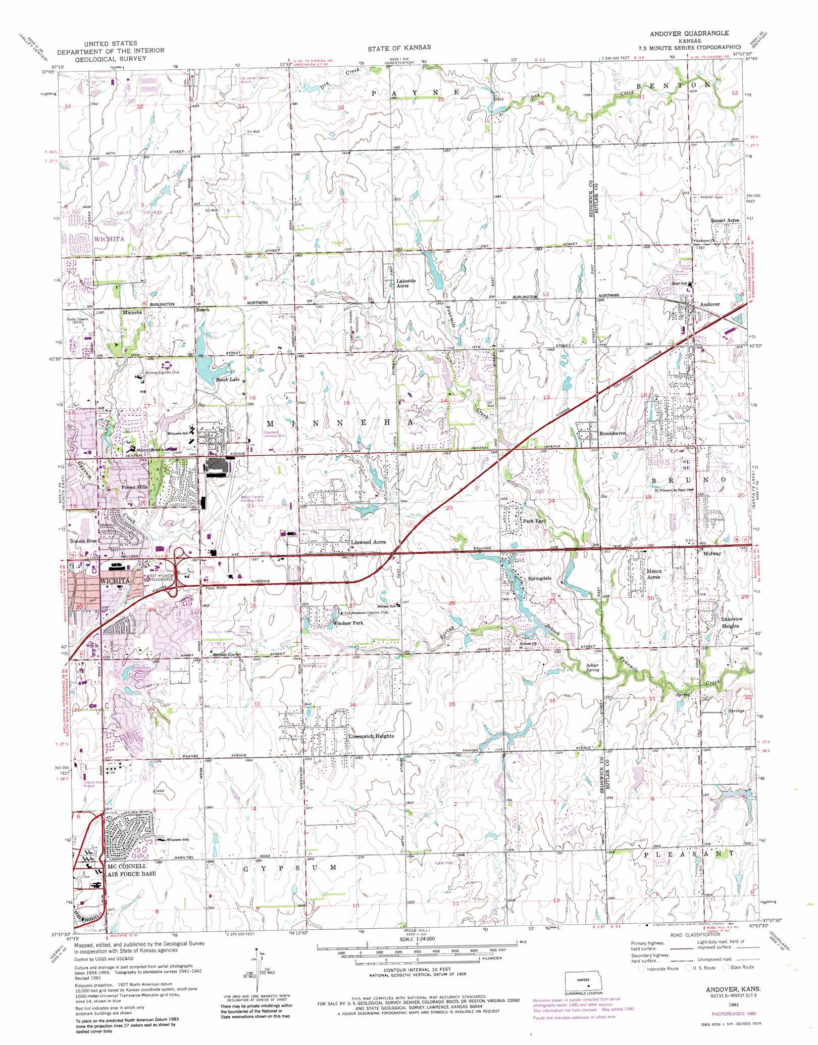
USGS Topo Quad 37097f2 - 1:24,000 scale
| Topo Map Name: | Andover |
| USGS Topo Quad ID: | 37097f2 |
| Print Size: | ca. 21 1/4" wide x 27" high |
| Southeast Coordinates: | 37.625° N latitude / 97.125° W longitude |
| Map Center Coordinates: | 37.6875° N latitude / 97.1875° W longitude |
| U.S. State: | KS |
| Filename: | o37097f2.jpg |
| Download Map JPG Image: | Andover topo map 1:24,000 scale |
| Map Type: | Topographic |
| Topo Series: | 7.5´ |
| Map Scale: | 1:24,000 |
| Source of Map Images: | United States Geological Survey (USGS) |
| Alternate Map Versions: |
Andover KS 1956, updated 1957 Download PDF Buy paper map Andover KS 1961, updated 1961 Download PDF Buy paper map Andover KS 1961, updated 1971 Download PDF Buy paper map Andover KS 1961, updated 1976 Download PDF Buy paper map Andover KS 1961, updated 1983 Download PDF Buy paper map Andover KS 2009 Download PDF Buy paper map Andover KS 2012 Download PDF Buy paper map Andover KS 2015 Download PDF Buy paper map |
1:24,000 Topo Quads surrounding Andover
Sedgwick |
Sedgwick Ne |
Whitewater |
Potwin |
El Dorado Nw |
Maize |
Valley Center |
Greenwich |
Benton |
El Dorado Sw |
Wichita West |
Wichita East |
Andover |
Santa Fe Lake |
Augusta |
Bayneville |
Derby |
Rose Hill |
Douglass |
Gordon |
Zyba |
Belle Plaine |
Mulvane |
Udall |
Wilmot |
> Back to 37097e1 at 1:100,000 scale
> Back to 37096a1 at 1:250,000 scale
> Back to U.S. Topo Maps home
Andover topo map: Gazetteer
Andover: Airports
Beech Factory Landing Field elevation 418m 1371′Cessna Aircraft Airport elevation 420m 1377′
Colonel James Jabara Airport elevation 434m 1423′
Copeland Landing Strip elevation 425m 1394′
Andover: Dams
Beech Lake and Park Dam elevation 415m 1361′Andover: Parks
Harrison Park elevation 414m 1358′Windsor Park elevation 408m 1338′
Andover: Populated Places
Andover elevation 412m 1351′Bonnie Brae elevation 413m 1354′
Brookhaven elevation 405m 1328′
Circle B Mobile Home Park elevation 411m 1348′
Forest Hills elevation 412m 1351′
Greenwich Heights elevation 412m 1351′
Kamar Parkette Trailer Park elevation 422m 1384′
Lakeside Acres elevation 416m 1364′
Lakeview Heights elevation 399m 1309′
Lifestyle Mobile Home Park elevation 417m 1368′
Linwood Acres elevation 417m 1368′
Lynwood Acres Mobile Home Park elevation 416m 1364′
Mecca Acres elevation 402m 1318′
Midway elevation 404m 1325′
Minneha elevation 421m 1381′
Park East elevation 409m 1341′
Park Village Mobile Home Park elevation 420m 1377′
Prairie Hills Mobile Home Park elevation 417m 1368′
Prairie Village elevation 414m 1358′
Springdale elevation 396m 1299′
Stroud Mobile Home Park elevation 415m 1361′
Sunset Acres elevation 414m 1358′
Travel - Air Mobile Home Park elevation 421m 1381′
Andover: Post Offices
Andover Post Office elevation 408m 1338′Andover: Reservoirs
Beech Lake elevation 415m 1361′Andover: Springs
Seltzer Spring elevation 391m 1282′Andover: Streams
Spring Branch elevation 387m 1269′Andover digital topo map on disk
Buy this Andover topo map showing relief, roads, GPS coordinates and other geographical features, as a high-resolution digital map file on DVD: