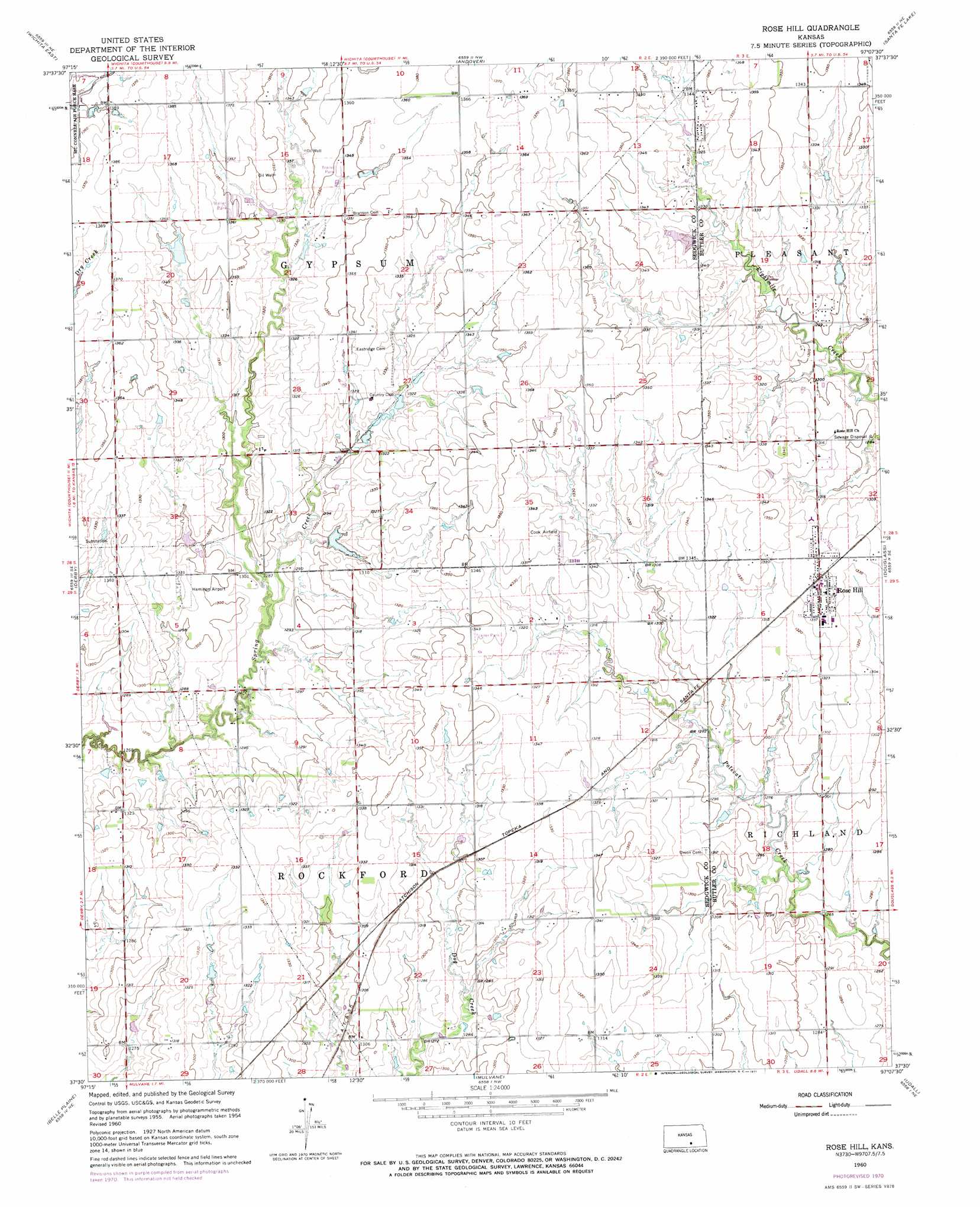
Rose Hill Topo Map Kansas
To zoom in, hover over the map of Rose Hill
USGS Topo Quad 37097e2 - 1:24,000 scale
| Topo Map Name: | Rose Hill |
| USGS Topo Quad ID: | 37097e2 |
| Print Size: | ca. 21 1/4" wide x 27" high |
| Southeast Coordinates: | 37.5° N latitude / 97.125° W longitude |
| Map Center Coordinates: | 37.5625° N latitude / 97.1875° W longitude |
| U.S. State: | KS |
| Filename: | o37097e2.jpg |
| Download Map JPG Image: | Rose Hill topo map 1:24,000 scale |
| Map Type: | Topographic |
| Topo Series: | 7.5´ |
| Map Scale: | 1:24,000 |
| Source of Map Images: | United States Geological Survey (USGS) |
| Alternate Map Versions: |
Rose Hill KS 1955, updated 1956 Download PDF Buy paper map Rose Hill KS 1960, updated 1961 Download PDF Buy paper map Rose Hill KS 1960, updated 1971 Download PDF Buy paper map Rose Hill KS 2009 Download PDF Buy paper map Rose Hill KS 2012 Download PDF Buy paper map Rose Hill KS 2015 Download PDF Buy paper map |
1:24,000 Topo Quads surrounding Rose Hill
Maize |
Valley Center |
Greenwich |
Benton |
El Dorado Sw |
Wichita West |
Wichita East |
Andover |
Santa Fe Lake |
Augusta |
Bayneville |
Derby |
Rose Hill |
Douglass |
Gordon |
Zyba |
Belle Plaine |
Mulvane |
Udall |
Wilmot |
Wellington |
Dalton |
Oxford |
Akron |
New Salem |
> Back to 37097e1 at 1:100,000 scale
> Back to 37096a1 at 1:250,000 scale
> Back to U.S. Topo Maps home
Rose Hill topo map: Gazetteer
Rose Hill: Airports
Cook Airfield elevation 409m 1341′Hamilton Field elevation 403m 1322′
Olson Aerodrome elevation 400m 1312′
Rose Hill: Populated Places
Longbranch Mobile Home Park elevation 413m 1354′Perrine Mobile Home Park elevation 404m 1325′
Rose Hill elevation 409m 1341′
Stonegate Mobile Home Park elevation 411m 1348′
Rose Hill: Post Offices
Rose Hill Post Office elevation 406m 1332′Rose Hill digital topo map on disk
Buy this Rose Hill topo map showing relief, roads, GPS coordinates and other geographical features, as a high-resolution digital map file on DVD: