Indian Head Topo Map Maryland
To zoom in, hover over the map of Indian Head
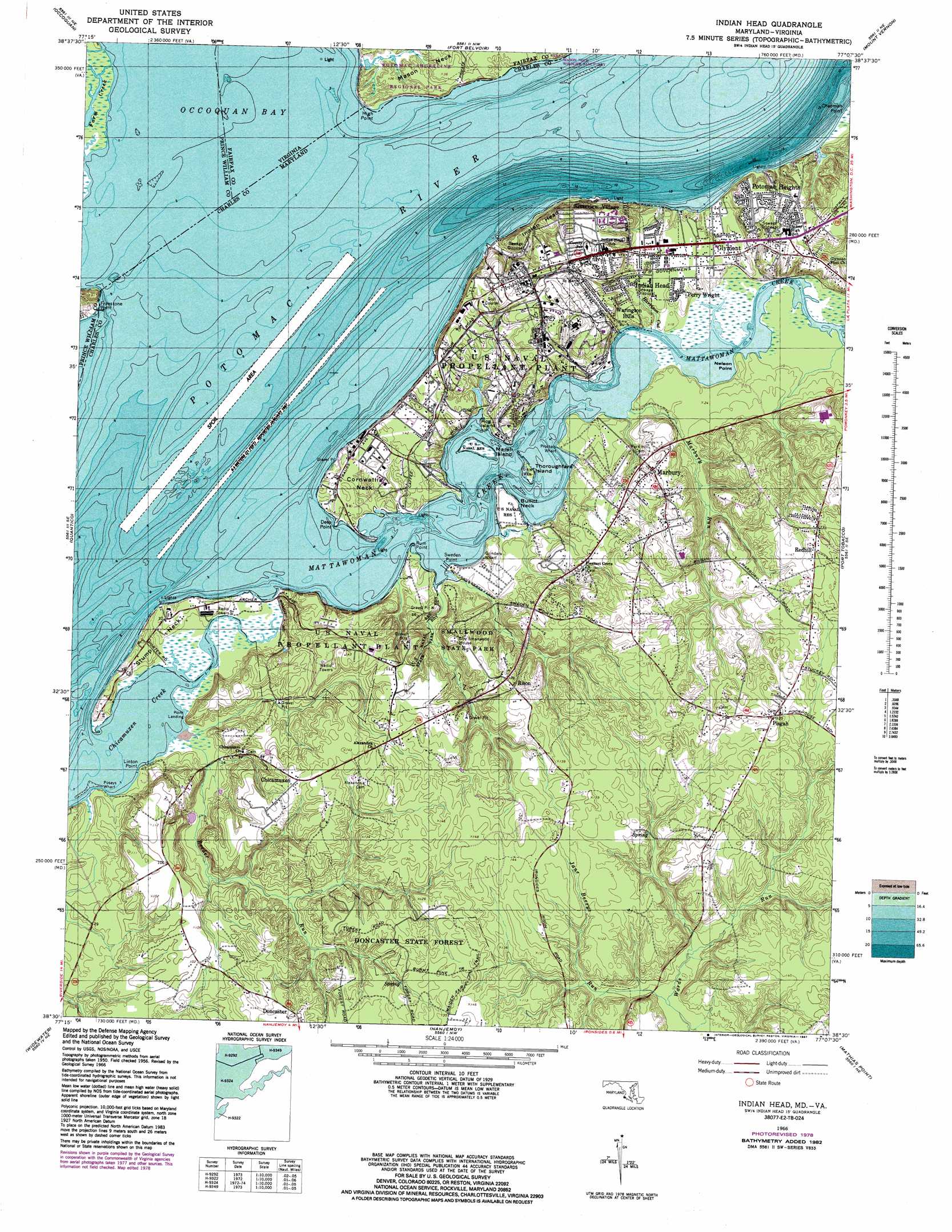
USGS Topo Quad 38077e2 - 1:24,000 scale
| Topo Map Name: | Indian Head |
| USGS Topo Quad ID: | 38077e2 |
| Print Size: | ca. 21 1/4" wide x 27" high |
| Southeast Coordinates: | 38.5° N latitude / 77.125° W longitude |
| Map Center Coordinates: | 38.5625° N latitude / 77.1875° W longitude |
| U.S. States: | MD, VA |
| Filename: | o38077e2.jpg |
| Download Map JPG Image: | Indian Head topo map 1:24,000 scale |
| Map Type: | Topographic |
| Topo Series: | 7.5´ |
| Map Scale: | 1:24,000 |
| Source of Map Images: | United States Geological Survey (USGS) |
| Alternate Map Versions: |
Indian Head MD 1951, updated 1954 Download PDF Buy paper map Indian Head MD 1951, updated 1954 Download PDF Buy paper map Indian Head MD 1956, updated 1959 Download PDF Buy paper map Indian Head MD 1966, updated 1968 Download PDF Buy paper map Indian Head MD 1966, updated 1968 Download PDF Buy paper map Indian Head MD 1966, updated 1975 Download PDF Buy paper map Indian Head MD 1966, updated 1978 Download PDF Buy paper map Indian Head MD 1966, updated 1983 Download PDF Buy paper map Indian Head MD 1966, updated 1987 Download PDF Buy paper map Indian Head MD 1977, updated 1982 Download PDF Buy paper map Indian Head MD 2011 Download PDF Buy paper map Indian Head MD 2014 Download PDF Buy paper map Indian Head MD 2016 Download PDF Buy paper map |
1:24,000 Topo Quads surrounding Indian Head
Manassas |
Fairfax |
Annandale |
Alexandria |
Anacostia |
Independent Hill |
Occoquan |
Fort Belvoir |
Mount Vernon |
Piscataway |
Joplin |
Quantico |
Indian Head |
Port Tobacco |
La Plata |
Stafford |
Widewater |
Nanjemoy |
Mathias Point |
Popes Creek |
Fredericksburg |
Passapatanzy |
King George |
Dahlgren |
Colonial Beach North |
> Back to 38077e1 at 1:100,000 scale
> Back to 38076a1 at 1:250,000 scale
> Back to U.S. Topo Maps home
Indian Head topo map: Gazetteer
Indian Head: Bays
Occoquan Bay elevation 0m 0′Indian Head: Capes
Bullitt Neck elevation 2m 6′Cornwallis Neck elevation 10m 32′
Deep Point elevation 8m 26′
Freestone Point elevation 5m 16′
High Point elevation 6m 19′
Linton Point elevation 0m 0′
Nelson Point elevation 0m 0′
Rum Point elevation 1m 3′
Stump Neck elevation 0m 0′
Sweden Point elevation 0m 0′
Indian Head: Cliffs
Indian Head elevation 0m 0′Indian Head: Forests
Doncaster State Forest elevation 33m 108′Indian Head: Islands
Hog Island elevation 9m 29′Marsh Island elevation 5m 16′
Thoroughfare Island elevation 0m 0′
Indian Head: Parks
Diffenbach Court Park elevation 35m 114′Mason Neck Wildlife Sanctuary elevation 0m 0′
Mattawoman State Natural Environmental Area elevation 12m 39′
Potomac Shoreline Regional Park elevation 14m 45′
Smallwood State Park elevation 1m 3′
Indian Head: Populated Places
Charleston Gardens elevation 40m 131′Chicamuxen elevation 25m 82′
Du-Mar Estates elevation 8m 26′
Glymont elevation 8m 26′
Holly Haven elevation 39m 127′
Indian Head elevation 29m 95′
Jones View elevation 43m 141′
Marbury elevation 23m 75′
Mattawoman Village elevation 9m 29′
Mattawoman Woods elevation 9m 29′
Montaine elevation 40m 131′
Perry Wright elevation 10m 32′
Pisgah elevation 38m 124′
Pleasant Grove Estates elevation 37m 121′
Potomac Heights elevation 23m 75′
Potomac Wood elevation 11m 36′
Redhill elevation 41m 134′
Redhill Estates elevation 41m 134′
Rison elevation 14m 45′
Rison Acres elevation 38m 124′
Riverview Village elevation 11m 36′
Smallwood Estates elevation 37m 121′
Warington Hills elevation 9m 29′
Winthrop (historical) elevation 9m 29′
Indian Head: Post Offices
Indian Head Post Office elevation 34m 111′Marbury Post Office elevation 22m 72′
Pisgah Post Office elevation 38m 124′
Rison Post Office elevation 36m 118′
Indian Head: Streams
Chicamuxen Creek elevation 0m 0′Farm Creek elevation 0m 0′
Harrison Cut elevation 4m 13′
Jane Berrys Run elevation 39m 127′
Marbury Run elevation 0m 0′
Mattawoman Creek elevation 0m 0′
Reeder Run elevation 0m 0′
Indian Head: Trails
Burnt Pine Trail elevation 38m 124′Maiden Fair Trail elevation 40m 131′
Indian Head digital topo map on disk
Buy this Indian Head topo map showing relief, roads, GPS coordinates and other geographical features, as a high-resolution digital map file on DVD:
Atlantic Coast (NY, NJ, PA, DE, MD, VA, NC)
Buy digital topo maps: Atlantic Coast (NY, NJ, PA, DE, MD, VA, NC)
 map DVD")