Keensburg Topo Map Indiana
To zoom in, hover over the map of Keensburg
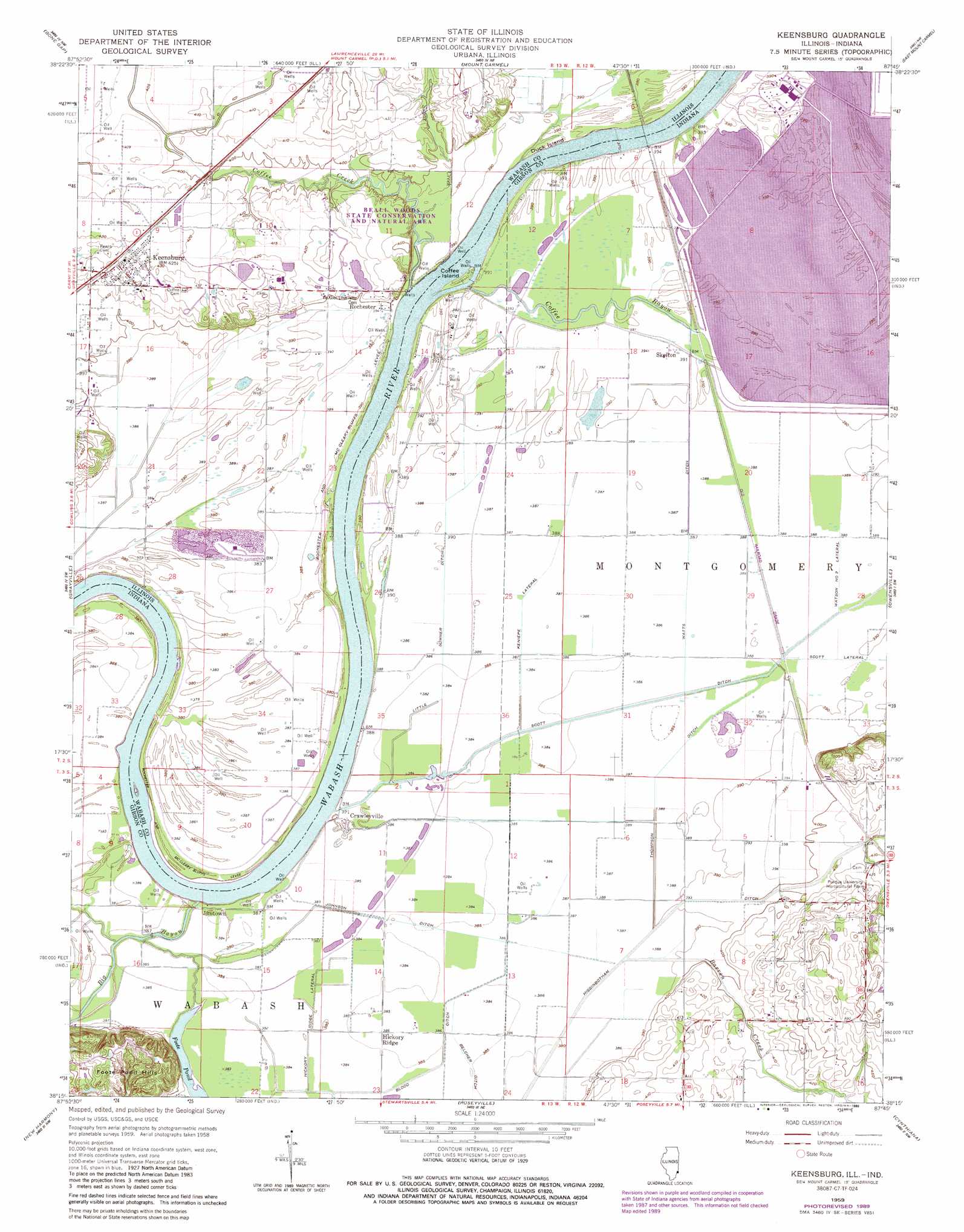
USGS Topo Quad 38087c7 - 1:24,000 scale
| Topo Map Name: | Keensburg |
| USGS Topo Quad ID: | 38087c7 |
| Print Size: | ca. 21 1/4" wide x 27" high |
| Southeast Coordinates: | 38.25° N latitude / 87.75° W longitude |
| Map Center Coordinates: | 38.3125° N latitude / 87.8125° W longitude |
| U.S. States: | IN, IL |
| Filename: | o38087c7.jpg |
| Download Map JPG Image: | Keensburg topo map 1:24,000 scale |
| Map Type: | Topographic |
| Topo Series: | 7.5´ |
| Map Scale: | 1:24,000 |
| Source of Map Images: | United States Geological Survey (USGS) |
| Alternate Map Versions: |
Keensburg IL 1959, updated 1961 Download PDF Buy paper map Keensburg IL 1959, updated 1981 Download PDF Buy paper map Keensburg IL 1959, updated 1989 Download PDF Buy paper map Keensburg IL 2010 Download PDF Buy paper map Keensburg IL 2012 Download PDF Buy paper map Keensburg IL 2015 Download PDF Buy paper map |
1:24,000 Topo Quads surrounding Keensburg
West Salem |
Berryville |
Lancaster |
Saint Francisville |
Decker |
Albion North |
Bone Gap |
Mount Carmel |
East Mount Carmel |
Patoka |
Albion South |
Grayville |
Keensburg |
Owensville |
Princeton |
Crossville |
New Harmony |
Poseyville |
Cynthiana |
Haubstadt |
Maunie |
Solitude |
Wadesville |
Kasson |
Evansville North |
> Back to 38087a1 at 1:100,000 scale
> Back to 38086a1 at 1:250,000 scale
> Back to U.S. Topo Maps home
Keensburg topo map: Gazetteer
Keensburg: Canals
Belcher Ditch elevation 117m 383′Blood Ditch elevation 117m 383′
Franks Ditch elevation 136m 446′
Hickory Ridge Lateral elevation 116m 380′
Higginbotham Ditch elevation 117m 383′
Johnson Ditch elevation 118m 387′
Keniepe Lateral elevation 118m 387′
Little Sumner Ditch elevation 118m 387′
Scott Ditch elevation 117m 383′
Scott Lateral elevation 118m 387′
Thompson Ditch elevation 118m 387′
Watts Ditch elevation 118m 387′
Keensburg: Dams
Gibson Public Service Generation Plant Dam elevation 117m 383′Keensburg: Islands
Coffee Island elevation 114m 374′Duck Island elevation 119m 390′
Keensburg: Lakes
Burnet Pond elevation 118m 387′Foote Pond elevation 116m 380′
Keensburg: Levees
Rochester and McCleary Bluffs Levee elevation 116m 380′Keensburg: Parks
Beall Woods Nature Preserve elevation 116m 380′Beall Woods State Conservation and Natural Area elevation 133m 436′
Keensburg: Populated Places
Crawleyville elevation 116m 380′Hickory Ridge elevation 117m 383′
Jimtown elevation 116m 380′
Keensburg elevation 133m 436′
Rochester elevation 120m 393′
Skelton elevation 119m 390′
Keensburg: Ranges
Foote Pond Hills elevation 136m 446′Keensburg: Streams
Barren Creek elevation 119m 390′Coffee Bayou elevation 116m 380′
Coffee Creek elevation 110m 360′
Johnson Drain elevation 124m 406′
Sugar Creek elevation 116m 380′
Keensburg: Swamps
Broad Pond elevation 117m 383′Keensburg: Woods
Beall Woods elevation 125m 410′Keensburg digital topo map on disk
Buy this Keensburg topo map showing relief, roads, GPS coordinates and other geographical features, as a high-resolution digital map file on DVD: