Stair Canyon Topo Map Utah
To zoom in, hover over the map of Stair Canyon
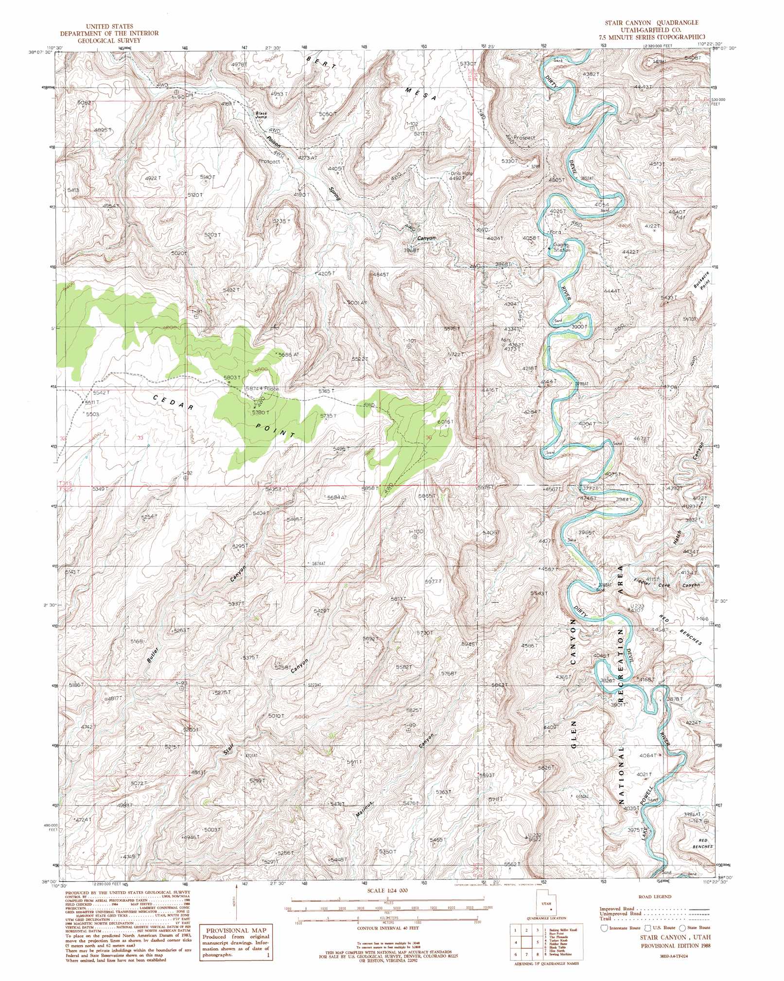
USGS Topo Quad 38110a4 - 1:24,000 scale
| Topo Map Name: | Stair Canyon |
| USGS Topo Quad ID: | 38110a4 |
| Print Size: | ca. 21 1/4" wide x 27" high |
| Southeast Coordinates: | 38° N latitude / 110.375° W longitude |
| Map Center Coordinates: | 38.0625° N latitude / 110.4375° W longitude |
| U.S. State: | UT |
| Filename: | o38110a4.jpg |
| Download Map JPG Image: | Stair Canyon topo map 1:24,000 scale |
| Map Type: | Topographic |
| Topo Series: | 7.5´ |
| Map Scale: | 1:24,000 |
| Source of Map Images: | United States Geological Survey (USGS) |
| Alternate Map Versions: |
Orange Cliffs 3 SW UT 1952, updated 1954 Download PDF Buy paper map Stair Canyon UT 1988, updated 1988 Download PDF Buy paper map Stair Canyon UT 2011 Download PDF Buy paper map Stair Canyon UT 2014 Download PDF Buy paper map |
1:24,000 Topo Quads surrounding Stair Canyon
Hanksville |
Angel Cove |
Angel Point |
Robbers Roost Flats |
Head Spur |
Bull Mountain |
Baking Skillet Knoll |
Burr Point |
The Pinnacle |
Gordon Flats |
Raggy Canyon |
Turkey Knob |
Stair Canyon |
Fiddler Butte |
Clearwater Canyon |
Cass Creek Peak |
Black Table |
Hite North |
Sewing Machine |
Bowdie Canyon West |
Copper Creek Benches |
Mount Holmes |
Hite South |
Copper Point |
Indian Head Pass |
> Back to 38110a1 at 1:100,000 scale
> Back to 38110a1 at 1:250,000 scale
> Back to U.S. Topo Maps home
Stair Canyon topo map: Gazetteer
Stair Canyon: Cliffs
Black Jump elevation 1332m 4370′Stair Canyon: Ridges
Cedar Point elevation 1831m 6007′Stair Canyon: Valleys
Fiddler Cove Canyon elevation 1160m 3805′Hatch Canyon elevation 1160m 3805′
Poison Spring Canyon elevation 1166m 3825′
Stair Canyon digital topo map on disk
Buy this Stair Canyon topo map showing relief, roads, GPS coordinates and other geographical features, as a high-resolution digital map file on DVD: