Camp Meeker Topo Map California
To zoom in, hover over the map of Camp Meeker
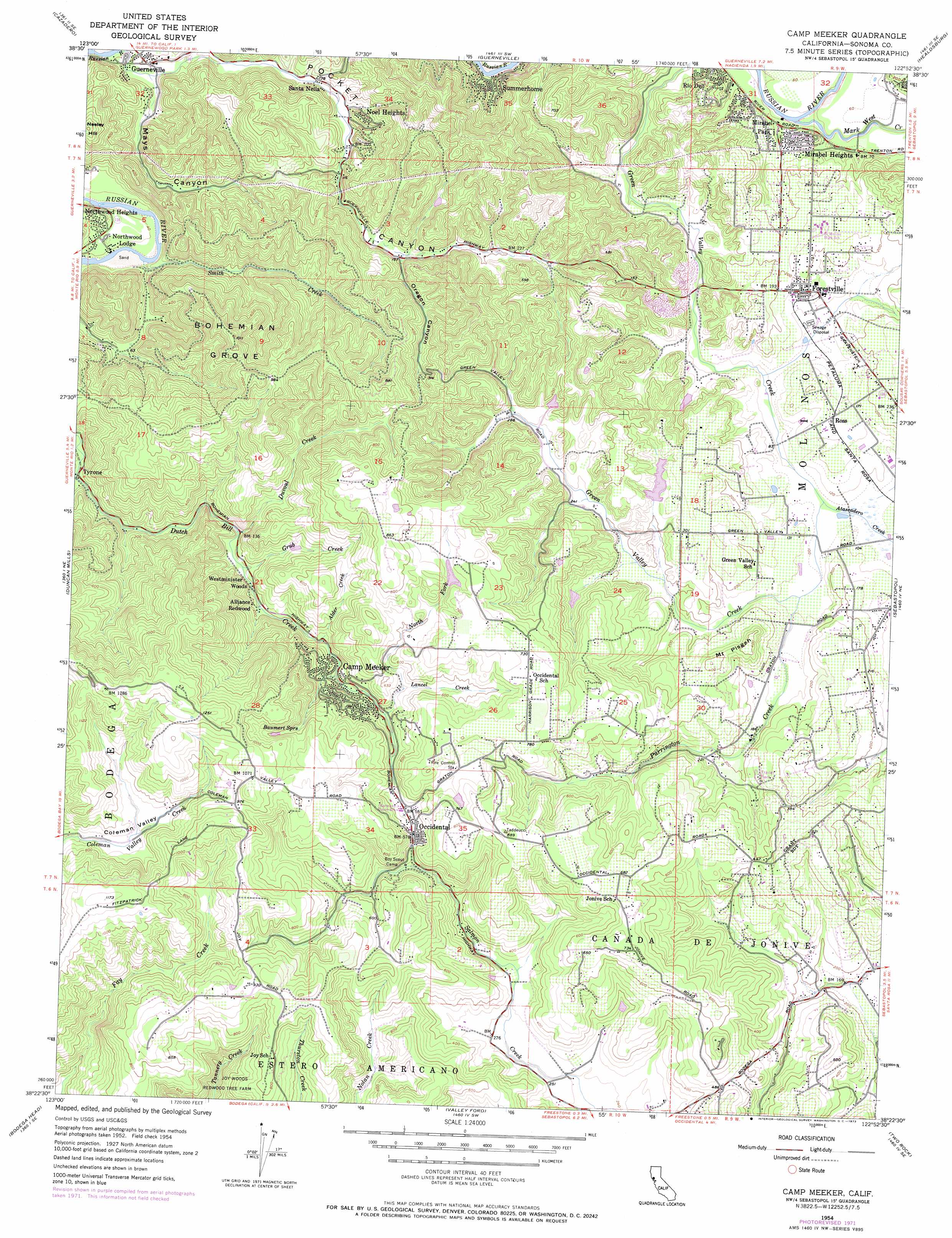
USGS Topo Quad 38122d8 - 1:24,000 scale
| Topo Map Name: | Camp Meeker |
| USGS Topo Quad ID: | 38122d8 |
| Print Size: | ca. 21 1/4" wide x 27" high |
| Southeast Coordinates: | 38.375° N latitude / 122.875° W longitude |
| Map Center Coordinates: | 38.4375° N latitude / 122.9375° W longitude |
| U.S. State: | CA |
| Filename: | o38122d8.jpg |
| Download Map JPG Image: | Camp Meeker topo map 1:24,000 scale |
| Map Type: | Topographic |
| Topo Series: | 7.5´ |
| Map Scale: | 1:24,000 |
| Source of Map Images: | United States Geological Survey (USGS) |
| Alternate Map Versions: |
Camp Meeker CA 1954, updated 1955 Download PDF Buy paper map Camp Meeker CA 1954, updated 1962 Download PDF Buy paper map Camp Meeker CA 1954, updated 1962 Download PDF Buy paper map Camp Meeker CA 1954, updated 1973 Download PDF Buy paper map Camp Meeker CA 1954, updated 1973 Download PDF Buy paper map Camp Meeker CA 1995, updated 1999 Download PDF Buy paper map Camp Meeker CA 2012 Download PDF Buy paper map Camp Meeker CA 2015 Download PDF Buy paper map |
1:24,000 Topo Quads surrounding Camp Meeker
Tombs Creek |
Warm Springs Dam |
Geyserville |
Jimtown |
Mount Saint Helena |
Fort Ross |
Cazadero |
Guerneville |
Healdsburg |
Mark West Springs |
Arched Rock |
Duncans Mills |
Camp Meeker |
Sebastopol |
Santa Rosa |
Bodega Head |
Valley Ford |
Two Rock |
Cotati |
|
Tomales |
Point Reyes Ne |
Petaluma |
> Back to 38122a1 at 1:100,000 scale
> Back to 38122a1 at 1:250,000 scale
> Back to U.S. Topo Maps home
Camp Meeker topo map: Gazetteer
Camp Meeker: Dams
Azalea 2420 Dam elevation 212m 695′Lake Helen 3425 Dam elevation 66m 216′
Camp Meeker: Parks
Forestville Youth Park elevation 65m 213′Camp Meeker: Populated Places
Alliance Redwood elevation 57m 187′Camp Meeker elevation 101m 331′
Forestville elevation 52m 170′
Harbine (historical) elevation 39m 127′
Lacresta (historical) elevation 51m 167′
Mirabel Heights elevation 22m 72′
Mirabel Park elevation 24m 78′
Noel Heights elevation 30m 98′
Northwood Heights elevation 42m 137′
Northwood Lodge elevation 19m 62′
Occidental elevation 181m 593′
Rio Dell elevation 36m 118′
Ross elevation 53m 173′
Santa Nella elevation 23m 75′
Summerhome Park elevation 20m 65′
Williams (historical) elevation 33m 108′
Camp Meeker: Post Offices
Camp Meeker Post Office elevation 104m 341′Forestville Post Office elevation 62m 203′
Occidental Post Office elevation 176m 577′
Camp Meeker: Springs
Baumert Springs elevation 230m 754′Camp Meeker: Streams
Alder Creek elevation 89m 291′Atascadero Creek elevation 27m 88′
Duvoul Creek elevation 46m 150′
Grab Creek elevation 48m 157′
Lancel Creek elevation 124m 406′
Mark West Creek elevation 0m 0′
North Fork Lancel Creek elevation 149m 488′
Purrington Creek elevation 34m 111′
Smith Creek elevation 2m 6′
Camp Meeker: Summits
Mount Pisgah elevation 132m 433′Camp Meeker: Valleys
Coleman Valley elevation 207m 679′Mays Canyon elevation 8m 26′
Oregon Canyon elevation 47m 154′
Pocket Canyon elevation 18m 59′
Camp Meeker: Woods
Bohemian Grove elevation 302m 990′Camp Meeker digital topo map on disk
Buy this Camp Meeker topo map showing relief, roads, GPS coordinates and other geographical features, as a high-resolution digital map file on DVD: