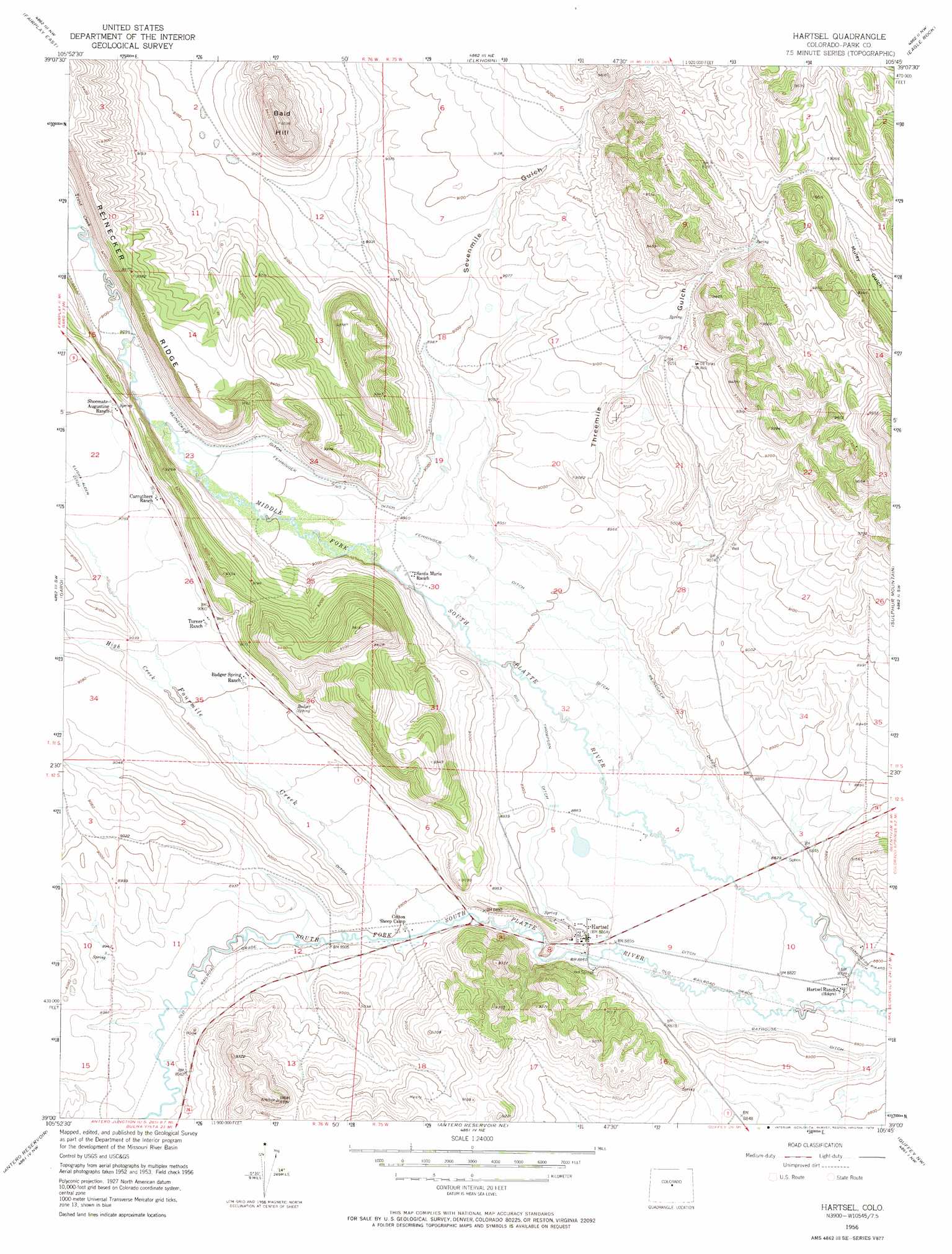
Hartsel Topo Map Colorado
To zoom in, hover over the map of Hartsel
USGS Topo Quad 39105a7 - 1:24,000 scale
| Topo Map Name: | Hartsel |
| USGS Topo Quad ID: | 39105a7 |
| Print Size: | ca. 21 1/4" wide x 27" high |
| Southeast Coordinates: | 39° N latitude / 105.75° W longitude |
| Map Center Coordinates: | 39.0625° N latitude / 105.8125° W longitude |
| U.S. State: | CO |
| Filename: | o39105a7.jpg |
| Download Map JPG Image: | Hartsel topo map 1:24,000 scale |
| Map Type: | Topographic |
| Topo Series: | 7.5´ |
| Map Scale: | 1:24,000 |
| Source of Map Images: | United States Geological Survey (USGS) |
| Alternate Map Versions: |
Hartsel CO 1956, updated 1957 Download PDF Buy paper map Hartsel CO 1956, updated 1957 Download PDF Buy paper map Hartsel CO 1956, updated 1974 Download PDF Buy paper map Hartsel CO 1956, updated 1974 Download PDF Buy paper map Hartsel CO 2010 Download PDF Buy paper map Hartsel CO 2013 Download PDF Buy paper map Hartsel CO 2016 Download PDF Buy paper map |
1:24,000 Topo Quads surrounding Hartsel
Alma |
Como |
Milligan Lakes |
Observatory Rock |
Topaz Mountain |
Fairplay West |
Fairplay East |
Elkhorn |
Eagle Rock |
Farnum Peak |
Jones Hill |
Garo |
Hartsel |
Sulphur Mountain |
Glentivar |
Marmot Peak |
Antero Reservoir |
Antero Reservoir Ne |
Guffey Nw |
Spinney Mountain |
Buena Vista East |
Castle Rock Gulch |
Agate Mountain |
Dicks Peak |
Thirtynine Mile Mountain |
> Back to 39105a1 at 1:100,000 scale
> Back to 39104a1 at 1:250,000 scale
> Back to U.S. Topo Maps home
Hartsel topo map: Gazetteer
Hartsel: Canals
Bathouse Ditch elevation 2697m 8848′Big Thompson Ditch elevation 2710m 8891′
Fehringer Number 1 Ditch elevation 2723m 8933′
Fehringer Number 2 Ditch elevation 2743m 8999′
Reinecker Ditch elevation 2734m 8969′
Hartsel: Mines
South Park Mining Company Mine elevation 2775m 9104′Hartsel: Populated Places
Hartsel elevation 2704m 8871′Hartsel: Springs
Badger Spring elevation 2750m 9022′Hartsel Hot Springs elevation 2702m 8864′
Hartsel: Streams
Fourmile Creek elevation 2709m 8887′High Creek elevation 2744m 9002′
Trout Creek elevation 2780m 9120′
Hartsel: Summits
Bald Hill elevation 2905m 9530′Hartsel: Valleys
Sevenmile Gulch elevation 2743m 8999′Threemile Gulch elevation 2714m 8904′
Hartsel digital topo map on disk
Buy this Hartsel topo map showing relief, roads, GPS coordinates and other geographical features, as a high-resolution digital map file on DVD: