Stoneham Ne Topo Map Colorado
To zoom in, hover over the map of Stoneham Ne
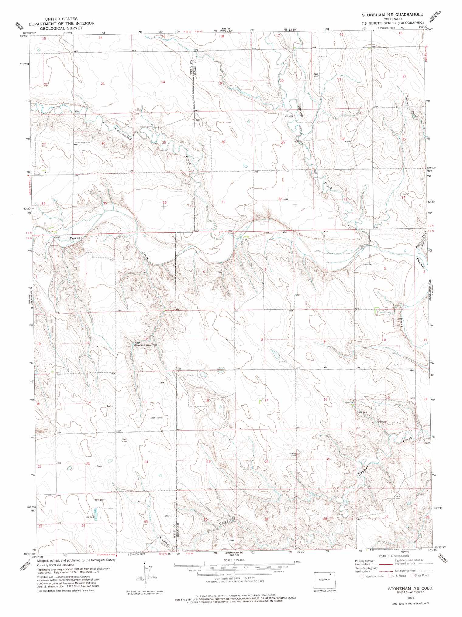
USGS Topo Quad 40103f5 - 1:24,000 scale
| Topo Map Name: | Stoneham Ne |
| USGS Topo Quad ID: | 40103f5 |
| Print Size: | ca. 21 1/4" wide x 27" high |
| Southeast Coordinates: | 40.625° N latitude / 103.5° W longitude |
| Map Center Coordinates: | 40.6875° N latitude / 103.5625° W longitude |
| U.S. State: | CO |
| Filename: | o40103f5.jpg |
| Download Map JPG Image: | Stoneham Ne topo map 1:24,000 scale |
| Map Type: | Topographic |
| Topo Series: | 7.5´ |
| Map Scale: | 1:24,000 |
| Source of Map Images: | United States Geological Survey (USGS) |
| Alternate Map Versions: |
Stoneham NE CO 1977, updated 1978 Download PDF Buy paper map Stoneham NE CO 1997, updated 2000 Download PDF Buy paper map Stoneham NE CO 2011 Download PDF Buy paper map Stoneham NE CO 2013 Download PDF Buy paper map Stoneham NE CO 2016 Download PDF Buy paper map |
| FStopo: | US Forest Service topo Stoneham NE is available: Download FStopo PDF Download FStopo TIF |
1:24,000 Topo Quads surrounding Stoneham Ne
Vim School |
Battle Canyon |
Dipper Spring |
Chimney Canyons |
Kirchnavy Butte |
Gatehook Spring |
Avalo |
Avalo Se |
Westplains |
North Sterling Reservoir |
Raymer Ne |
Stoneham Nw |
Stoneham Ne |
Wild Horse Lake |
Atwood Ne |
Raymer |
Stoneham |
Stoneham Se |
Willard |
Atwood |
Peace Valley School |
Dead Horse Springs |
Antelope Springs |
Messex |
Merino |
> Back to 40103e1 at 1:100,000 scale
> Back to 40102a1 at 1:250,000 scale
> Back to U.S. Topo Maps home
Stoneham Ne topo map: Gazetteer
Stoneham Ne: Reservoirs
East Stoneham Reservoir elevation 1352m 4435′Stoneham Ne: Streams
Cottonwood Creek elevation 1305m 4281′Spring Creek elevation 1293m 4242′
Stoneham Ne: Wells
Hot Shot Well elevation 1399m 4589′Stoneham Ne digital topo map on disk
Buy this Stoneham Ne topo map showing relief, roads, GPS coordinates and other geographical features, as a high-resolution digital map file on DVD: