Powder Mountain Ne Topo Map Wyoming
To zoom in, hover over the map of Powder Mountain Ne
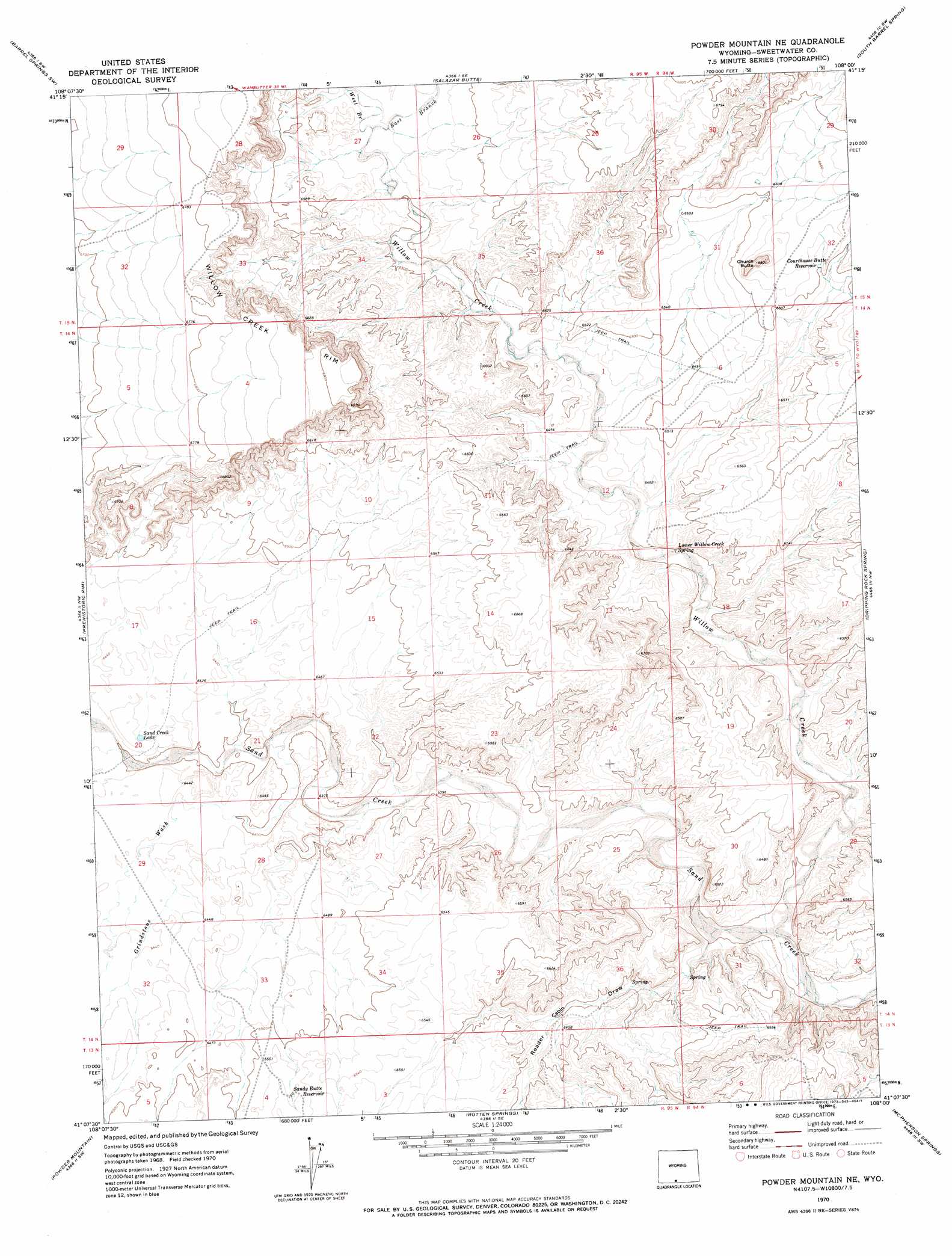
USGS Topo Quad 41108b1 - 1:24,000 scale
| Topo Map Name: | Powder Mountain Ne |
| USGS Topo Quad ID: | 41108b1 |
| Print Size: | ca. 21 1/4" wide x 27" high |
| Southeast Coordinates: | 41.125° N latitude / 108° W longitude |
| Map Center Coordinates: | 41.1875° N latitude / 108.0625° W longitude |
| U.S. State: | WY |
| Filename: | o41108b1.jpg |
| Download Map JPG Image: | Powder Mountain Ne topo map 1:24,000 scale |
| Map Type: | Topographic |
| Topo Series: | 7.5´ |
| Map Scale: | 1:24,000 |
| Source of Map Images: | United States Geological Survey (USGS) |
| Alternate Map Versions: |
Powder Mountain NE WY 1970, updated 1973 Download PDF Buy paper map Powder Mountain NE WY 2012 Download PDF Buy paper map Powder Mountain NE WY 2015 Download PDF Buy paper map |
1:24,000 Topo Quads surrounding Powder Mountain Ne
Fort La Clede Ne |
Haystack Flats |
Barrel Springs |
Mexican Flats Nw |
Duck Lake |
Manuel Gap |
Barrel Springs Sw |
Salazar Butte |
South Barrel Spring |
Mexican Flats |
Monument Valley |
Prehistoric Rim |
Powder Mountain Ne |
Dripping Rock Spring |
Flat Top Mountain |
Upper Powder Spring |
Powder Mountain |
Rotten Springs |
Mcpherson Springs |
Poison Basin |
Powder Wash |
Reservoir Draw |
The Nipple Ne |
Bighole Butte |
Thornburgh Gulch |
> Back to 41108a1 at 1:100,000 scale
> Back to 41108a1 at 1:250,000 scale
> Back to U.S. Topo Maps home
Powder Mountain Ne topo map: Gazetteer
Powder Mountain Ne: Cliffs
Willow Creek Rim elevation 2108m 6916′Powder Mountain Ne: Lakes
Sand Creek Lake elevation 1959m 6427′Powder Mountain Ne: Reservoirs
Courthouse Butte Reservoir elevation 2018m 6620′Sandy Butte Reservoir elevation 1995m 6545′
Powder Mountain Ne: Springs
Lower Willow Creek Spring elevation 1952m 6404′Powder Mountain Ne: Streams
East Branch Willow Creek elevation 1993m 6538′West Branch Willow Creek elevation 1992m 6535′
Willow Creek elevation 1916m 6286′
Powder Mountain Ne: Summits
Church Butte elevation 2065m 6774′Powder Mountain Ne: Valleys
Grindstone Wash elevation 1946m 6384′Reader Cabin Draw elevation 1921m 6302′
Powder Mountain Ne digital topo map on disk
Buy this Powder Mountain Ne topo map showing relief, roads, GPS coordinates and other geographical features, as a high-resolution digital map file on DVD: