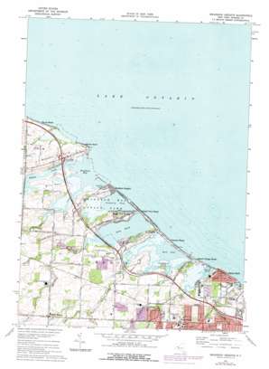
Braddock Heights Topo Map New York
To zoom in, hover over the map of Braddock Heights
USGS Topo Quad 43077c6 - 1:24,000 scale
| Topo Map Name: | Braddock Heights |
| USGS Topo Quad ID: | 43077c6 |
| Print Size: | ca. 21 1/4" wide x 27" high |
| Southeast Coordinates: | 43.25° N latitude / 77.625° W longitude |
| Map Center Coordinates: | 43.3125° N latitude / 77.6875° W longitude |
| U.S. State: | NY |
| Filename: | o43077c6.jpg |
| Download Map JPG Image: | Braddock Heights topo map 1:24,000 scale |
| Map Type: | Topographic |
| Topo Series: | 7.5´ |
| Map Scale: | 1:24,000 |
| Source of Map Images: | United States Geological Survey (USGS) |
| Alternate Map Versions: |
Braddock Heights NY 1934 Download PDF Buy paper map Braddock Heights NY 1934 Download PDF Buy paper map Braddock Heights NY 1934, updated 1950 Download PDF Buy paper map Braddock Heights NY 1952, updated 1954 Download PDF Buy paper map Braddock Heights NY 1952, updated 1954 Download PDF Buy paper map Braddock Heights NY 1952, updated 1962 Download PDF Buy paper map Braddock Heights NY 1952, updated 1970 Download PDF Buy paper map Braddock Heights NY 1971, updated 1973 Download PDF Buy paper map Braddock Heights NY 1971, updated 1978 Download PDF Buy paper map Braddock Heights NY 2010 Download PDF Buy paper map Braddock Heights NY 2013 Download PDF Buy paper map Braddock Heights NY 2016 Download PDF Buy paper map |
1:24,000 Topo Quads surrounding Braddock Heights
Hamlin |
Hilton |
Braddock Heights |
Ninemile Point |
|
Brockport |
Spencerport |
Rochester West |
Rochester East |
Webster |
Churchville |
Clifton |
West Henrietta |
Pittsford |
Fairport |
> Back to 43077a1 at 1:100,000 scale
> Back to 43076a1 at 1:250,000 scale
> Back to U.S. Topo Maps home
Braddock Heights topo map: Gazetteer
Braddock Heights: Bars
Lewis Shoal elevation 74m 242′Braddock Heights: Bays
Braddock Bay elevation 74m 242′Braddock Heights: Capes
Beatty Point elevation 83m 272′Bills Point elevation 77m 252′
Braddock Point elevation 81m 265′
Lewis Point elevation 78m 255′
O'Neil Point elevation 76m 249′
Braddock Heights: Islands
Huckleberry Island elevation 75m 246′Braddock Heights: Lakes
Buck Pond elevation 75m 246′Cranberry Pond elevation 75m 246′
Little Pond elevation 76m 249′
Long Pond elevation 75m 246′
Round Pond elevation 75m 246′
Braddock Heights: Parks
Braddock Bay Fish and Wildlife Management Area elevation 76m 249′Braddock Heights: Populated Places
Braddock Heights elevation 78m 255′Crescent Beach elevation 76m 249′
Grand View Beach elevation 76m 249′
Grand View Heights elevation 83m 272′
Island Cottage Beach elevation 76m 249′
Manitou Beach elevation 79m 259′
Mount Read elevation 105m 344′
North Greece elevation 102m 334′
Payne Beach elevation 76m 249′
Rigney Bluff elevation 79m 259′
Braddock Heights: Streams
Black Creek elevation 76m 249′Buttonwood Creek elevation 74m 242′
Fleming Creek elevation 75m 246′
Kirk Creek elevation 79m 259′
Larkin Creek elevation 75m 246′
Northrup Creek elevation 75m 246′
Paddy Hill Creek elevation 77m 252′
Round Pond Creek elevation 75m 246′
Salmon Creek elevation 74m 242′
Slater Creek elevation 75m 246′
Smith Creek elevation 87m 285′
West Creek elevation 75m 246′
Braddock Heights: Summits
Frisbee Hill elevation 97m 318′Paddy Hill elevation 105m 344′
Braddock Heights digital topo map on disk
Buy this Braddock Heights topo map showing relief, roads, GPS coordinates and other geographical features, as a high-resolution digital map file on DVD:
New York, Vermont, Connecticut & Western Massachusetts
Buy digital topo maps: New York, Vermont, Connecticut & Western Massachusetts


